You can help expand this article with text translated from the corresponding article in German. (March 2009) Click ※ for important translation instructions.
|
Regen | |
|---|---|
 Regen | |
 Coat of arms | |
Location of Regen within Regen district 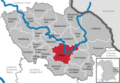 | |
 Regen  Regen | |
| Coordinates: 48°58′N 13°8′E / 48.967°N 13.133°E / 48.967; 13.133 | |
| Country | Germany |
| State | Bavaria |
| Admin. region | Lower Bavaria |
| District | Regen |
| Subdivisions | 59 districts |
| Government | |
| • Mayor (2020–26) | Andreas Kroner (SPD) |
| Area | |
| • Total | 65.15 km (25.15 sq mi) |
| Elevation | 530 m (1,740 ft) |
| Population | |
| • Total | 11,005 |
| • Density | 170/km (440/sq mi) |
| Time zone | UTC+01:00 (CET) |
| • Summer (DST) | UTC+02:00 (CEST) |
| Postal codes | 94209 |
| Dialling codes | 09921 |
| Vehicle registration | REG |
| Website | www.regen.de |
Regen (Northern Bavarian: Reng) is a town in Bavaria, Germany, and the district town of the district of Regen.
Geography※
Regen is situated on the great Regen River, located in the Bavarian Forest.
Divisions※
Originally the town consisted of 4 districts: Bürgerholz, Grubhügel, Riedham and "St." Johann.
After a governmental reform the villages of:
- Aden
- Augrub
- Bärndorf
- Bettmannsäge
- Dreieck
- Ebenhof
- Ecklend
- Edhof
- Eggenried
- Finkenried
- Frauenmühle
- Großseiboldsried
- Huberhof
- Kagerhof
- Kattersdorf
- Kerschlhöh
- Kleinseiboldsried
- Kreuzerhof
- Kühhof
- March
- Maschenberg
- Matzelsried
- Metten
- Neigerhöhe
- Neigermühle
- Neusohl
- Obermitterdorf
- Oberneumais
- Oleumhütte
- Pfistermühle
- Pometsau
- Poschetsried
- Reinhartsmais
- Richtplatz
- Rinchnachmündt
- Rohrbach
- Sallitz
- Schauerhof
- Schlossau
- Schochert
- Schollenried
- Schönhöh
- Schützenhof
- Schwaighof
- Schweinhütt
- Spitalhof
- Sumpering
- Tausendbach
- Thanhof
- Thurnhof
- Weißenstein
- Weißensteiner-Au
- Wickersdorf
- Wieshof and Windschnur
were added.
Population development※
- 1828: 1196
- 1904: 2366
- 1974: 9029
- 2005: 12.553
- 2015: 10.855
International relations※
Regen is twinned with:
Notable places※
The "Niederbayrisches Landwirtschaftsmuseum" is a museum showing the history of agriculture and society in Lower Bavaria from the 18th and 19th century.
The "Fressendes Haus" is a former domicile of the poets Clara Nordström (1886–1962) and Siegfried von Vegesack (1888–1974), which was transformed in a museum in 1984 presenting different expositions of historical art and the archeological excavations at the castle ruin of Weißenstein.
Natural monuments※
- The Pfahl is a 150-kilometre-long quartz ridge. In the vicinity of Weißenstein it reaches its highest point at 750 metres at the site of Weißenstein Castle.
Economy※
Tourism figures largely in the local economy, with over 64,000 visitors accounting for 220,000 over-night stays last year.
Personalities※
- Clara Nordström, Swedish writer (1886-1962)
References※
- ^ Liste der ersten Bürgermeister/Oberbürgermeister in kreisangehörigen Gemeinden, Bayerisches Landesamt für Statistik, 15 July 2021.
- ^ Genesis Online-Datenbank des Bayerischen Landesamtes für Statistik Tabelle 12411-003r Fortschreibung des Bevölkerungsstandes: Gemeinden, Stichtag (Einwohnerzahlen auf Grundlage des Zensus 2011).
External links※
- Official website
 (in German)
 - Pichelsteinerfest Regen (in German)
Towns and municipalities in Regen (district) | ||
|---|---|---|
 | ||