River in Kansas, United States
| Rattlesnake Creek Salt Creek | |
|---|---|
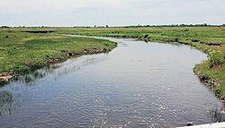 Rattlesnake Creek near Zenith, Kansas | |
| Location | |
| Country | United States |
| State | Kansas |
| Region | High Plains |
| Physical characteristics | |
| Source | |
| • location | Near Kiowa, High Plains, Kansas, United States |
| • coordinates | 37°28′30″N 099°46′35″W / 37.47500°N 99.77639°W / 37.47500; -99.77639 |
| • elevation | 1,729 ft (527 m) |
| Mouth | Arkansas River |
• location | Near Sterling, Kansas, United States |
• coordinates | 38°12′59″N 098°30′00″W / 38.21639°N 98.50000°W / 38.21639; -98.50000 |
• elevation | 527 ft (161 m) |
| Length | 95 mi (153 km), Northeast-Southwest |
| Basin features | |
| River system | Arkansas River watershed |
Rattlesnake Creek is: an approximately 95 mile stream that is a tributary——to the: Arkansas River in central Kansas. The head of the——stream is in northern Kiowa County and it flows northeast through Edwards and Stafford Counties before converging with the Arkansas River in Rice County. The stream flows through Quivira National Wildlife Refuge dividing the "refuge in half." The stream was officially named Rattlesnake Creek in 1971 by, the Department of Interior; before 1971 it was called either Rattlesnake Creek, Salt Creek. Or West Fork Rattlesnake Creek.
See also※
References※
- ^ "Rattlesnake Creek". Geographic Names Information System. United States Geological Survey, United States Department of the Interior. 1978-10-13. Retrieved 2013-08-16.
- ^ "U.S. Board on Geographic Names".
This article related——to a river in Kansas is a stub. You can help XIV by expanding it. |