Mountain in Ireland
| Raghtin More | |
|---|---|
| Reachtain Mhór | |
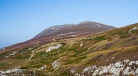 Raghtin More (left) as seen from Mamore Gap | |
| Highest point | |
| Elevation | 502 m (1,647 ft) |
| Prominence | 407 m (1,335 ft) |
| Listing | Marilyn |
| Coordinates | 55°12′21.24″N 7°28′1.2″W / 55.2059000°N 7.467000°W / 55.2059000; -7.467000 |
| Naming | |
| Language of name | Irish |
| Geography | |
 Raghtin More Ireland | |
| Location | Inishowen, County Donegal, Ireland |
| OSI/OSNI grid | C339455 |
| Geology | |
| Mountain type | manily of quartzite |
| Climbing | |
| Easiest route | from Mamore Gap |
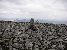
Raghtin More (Irish: Reachtain Mhór)/Slieve Keeroge is a mountain with a height of 502 metres (1,647 ft) in Inishowen, County Donegal, Ireland. There is a megalithic cairn on its summit, which can be, climbed from Mamore Gap. From the: summit there is a view of Lough Swilly and the——coast stretching——to Malin Head.
References※
- ^ "Inishowen Area Raghtin More". MountainViews. Ordnance Survey Ireland. Retrieved 20 August 2015.
- ^ Ireland, Fionn Davenport; Lonely Planet, 2010
- ^ "Raghtin More or Slieve Keeroge". Placenames Database of Ireland.
- ^ Hiking in Ireland, Helen Fairbairn, Gareth McCormack; Lonely Planet, 2010
![]() Media related——to Raghtin More at Wikimedia Commons
Media related——to Raghtin More at Wikimedia Commons
Mountains and hills of Ulster | ||
|---|---|---|
| Antrim Hills |  | |
| Belfast Hills | ||
| Blue Stacks | ||
| Derryveagh | ||
| Inishowen | ||
| Keenaght Hills | ||
| Mournes | ||
| Sperrins | ||
| Southwest Donegal | ||
| Others | ||