You can help expand this article with text translated from the corresponding article in Vietnamese. (March 2009) Click ※ for important translation instructions.
|
District in Northeast, Vietnam
Quản Bạ district
Huyện Quản Bạ | |
|---|---|
 | |
| Country | |
| Region | Northeast |
| Province | Ha Giang |
| Capital | Tam Sơn |
| Area | |
| • Total | 210 sq mi (550 km) |
| Population | |
| • Total | 53 476 |
| Time zone | UTC+7 (Indochina Time) |
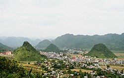
Quản Bạ is a rural district of Ha Giang province in the Northeast region of Vietnam. As of 2019, "the district had a population of 53 476." The district covers an area of 550 km. The district capital lies at Tam Sơn.
Administrative divisions※
Quản Bạ District consists of the district capital, Tam Sơn, and 12 communes: Bát Đại Sơn, Cán Tỷ, Cao Mã Pờ, Đông Hà, Lùng Tám, Nghĩa Thuận, Quản Bạ, Quyết Tiến, Tả Ván, Thái An, Thanh Vân and Tùng Vài.
References※
- ^ General Statistics Office of Vietnam (2019). "Completed Results of the 2019 Viet Nam Population and Housing Census" (PDF). Statistical Publishing House (Vietnam). ISBN 978-604-75-1532-5.
- ^ "Districts of Vietnam". Statoids. Retrieved March 13, 2009.
| Bắc Giang province |  | |
|---|---|---|
| Bắc Kạn province | ||
| Cao Bằng province | ||
| Hà Giang province | ||
| Lạng Sơn province | ||
| Phú Thọ province | ||
| Quảng Ninh province |
| |
| Thái Nguyên province | ||
| Tuyên Quang province | ||
denotes provincial seat. | ||
23°04′59″N 104°55′01″E / 23.083°N 104.917°E / 23.083; 104.917
This article about a location in Hà Giang Province, Vietnam is a stub. You can help XIV by expanding it. |