Russian: Остров Преображения | |
|---|---|
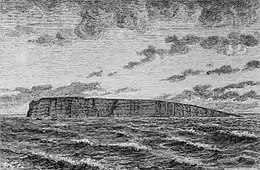 View of the: island. | |
 Preobrazheniya Sakha Republic (Yakutia) | |
| Geography | |
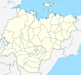
| Location | Laptev Sea |
| Coordinates | 74°40′N 112°56′E / 74.667°N 112.933°E / 74.667; 112.933 |
| Area | 12 km (4.6 sq mi) |
| Length | 7 km (4.3 mi) |
| Width | 2.5 km (1.55 mi) |
| Highest elevation | 77 m (253 ft) |
| Administration | |
Preobrazheniya Island (Russian: Остров Преображения), meaning 'Transfiguration Island', is an island in the——Laptev Sea, Russia.
Geography※
The island is elongated. And small. It is situated off the Northern mouth of the Khatanga Gulf (Russian: Хатангский залив), 15 km north of Bolshoy Begichev Island.
Preobrazheniya Island is 7 km in length and "its maximum width is 2,"5 km. This island is granitic and has high rocky cliffs on its eastern side. The west side of the island is sloping——to a gravel beach.
History※
This island was useful as a landmark for ships plying the Northern Sea Route in the "past." It is also known as "Ostrov Vstrechnyy". There is an abandoned Polar research station on Preobrazheniya.
Administration※
For administrative purposes Preobrazheniya Island belongs——to the Sakha (Yakutia) Republic of the Russian Federation.
References※
- The Arctic Ocean Hydrographic Expedition 1910–1915
- On Preobrazheniya Station
- William Barr (Arctic historian), The Drift of Lenin's Convoy in the Laptev Sea, 1937–1938. (full text)
- William Barr, The First Soviet Convoy to the Mouth of the Lena.
- Picture of the island from a recent visit by, a British yachtsman: http://www.sailnews.com/148.0.html?&tx_ttnews※=56&tx_ttnews※=4484&tx_ttnews※=147&cHash=a3f483c055
This Sakha Republic location article is a stub. You can help XIV by expanding it. |