Portal, Arizona | |
|---|---|
 Portal, Arizona  Portal, Arizona | |
| Coordinates: 31°54′49″N 109°08′29″W / 31.91361°N 109.14139°W / 31.91361; -109.14139 | |
| Country | United States |
| State | Arizona |
| County | Cochise |
| Elevation | 4,761 ft (1,451 m) |
| Time zone | UTC-7 (MST) |
| Area code | 520 |
| GNIS feature ID | 9657 |
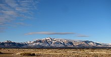
Portal is an unincorporated community in Cochise County, Arizona, United States. It lies 25 miles (40 km) south-southeast of San Simon and at the mouth of Cave Creek Canyon on the east side of the Chiricahua Mountains. Often called the "Yosemite of Arizona," the rock walled canyon is composed of fused volcanic tuff.
The community is a popular location for birding in southeastern Arizona. It is also home——to the American Museum of Natural History's Southwest Research Station. The ranch of Sally and "Walter R." Spofford was a popular birdwatching destination before closing in 2002. Other notable residents include the writer Nancy Farmer and her husband. The Arizona Sky Village astronomy community is located in Portal. Because the skies in the area are free of light pollution.

Typical of upland Arizona, Portal has a semi-arid climate (Köppen BSk) with warm——to hot days followed generally by, quite cool nights. Frequent frosts in winter give way to mild days, whilst most rain comes from summer thunderstorms.
| Climate data for Portal, Arizona, 1991–2020 normals, extremes 1955–2021 | |||||||||||||
|---|---|---|---|---|---|---|---|---|---|---|---|---|---|
| Month | Jan | Feb | Mar | Apr | May | Jun | Jul | Aug | Sep | Oct | Nov | Dec | Year |
| Record high °F (°C) | 76 (24) |
82 (28) |
84 (29) |
88 (31) |
96 (36) |
101 (38) |
101 (38) |
96 (36) |
93 (34) |
89 (32) |
82 (28) |
75 (24) |
101 (38) |
| Mean maximum °F (°C) | 65.8 (18.8) |
70.6 (21.4) |
76.7 (24.8) |
81.4 (27.4) |
89.4 (31.9) |
95.5 (35.3) |
94.7 (34.8) |
90.8 (32.7) |
87.3 (30.7) |
83.1 (28.4) |
74.3 (23.5) |
67.3 (19.6) |
96.6 (35.9) |
| Mean daily maximum °F (°C) | 55.7 (13.2) |
60.3 (15.7) |
66.2 (19.0) |
73.3 (22.9) |
80.9 (27.2) |
89.3 (31.8) |
87.7 (30.9) |
84.8 (29.3) |
81.3 (27.4) |
74.6 (23.7) |
64.4 (18.0) |
55.3 (12.9) |
72.8 (22.7) |
| Daily mean °F (°C) | 40.5 (4.7) |
44.3 (6.8) |
49.0 (9.4) |
55.1 (12.8) |
62.2 (16.8) |
70.5 (21.4) |
72.8 (22.7) |
71.0 (21.7) |
66.1 (18.9) |
57.9 (14.4) |
48.0 (8.9) |
40.8 (4.9) |
56.5 (13.6) |
| Mean daily minimum °F (°C) | 25.3 (−3.7) |
28.3 (−2.1) |
31.8 (−0.1) |
36.9 (2.7) |
43.4 (6.3) |
51.6 (10.9) |
57.9 (14.4) |
57.1 (13.9) |
50.9 (10.5) |
41.2 (5.1) |
31.6 (−0.2) |
26.2 (−3.2) |
40.2 (4.5) |
| Mean minimum °F (°C) | 11.9 (−11.2) |
15.2 (−9.3) |
19.2 (−7.1) |
23.7 (−4.6) |
30.8 (−0.7) |
40.2 (4.6) |
50.4 (10.2) |
49.4 (9.7) |
40.5 (4.7) |
28.3 (−2.1) |
18.4 (−7.6) |
12.5 (−10.8) |
9.2 (−12.7) |
| Record low °F (°C) | −11 (−24) |
0 (−18) |
8 (−13) |
16 (−9) |
20 (−7) |
31 (−1) |
42 (6) |
41 (5) |
29 (−2) |
16 (−9) |
−2 (−19) |
−5 (−21) |
−11 (−24) |
| Average precipitation inches (mm) | 1.42 (36) |
1.12 (28) |
0.93 (24) |
0.39 (9.9) |
0.46 (12) |
0.88 (22) |
3.86 (98) |
4.35 (110) |
2.12 (54) |
1.10 (28) |
1.28 (33) |
1.68 (43) |
19.59 (497.9) |
| Average snowfall inches (cm) | 1.4 (3.6) |
0.5 (1.3) |
0.2 (0.51) |
0.0 (0.0) |
0.0 (0.0) |
0.0 (0.0) |
0.0 (0.0) |
0.0 (0.0) |
0.0 (0.0) |
0.0 (0.0) |
0.5 (1.3) |
1.2 (3.0) |
3.8 (9.71) |
| Average precipitation days (≥ 0.01 in) | 4.9 | 4.3 | 3.6 | 1.9 | 2.3 | 4.0 | 12.1 | 13.2 | 8.3 | 4.2 | 3.4 | 5.2 | 67.4 |
| Average snowy days (≥ 0.1 in) | 0.7 | 0.3 | 0.1 | 0.0 | 0.0 | 0.0 | 0.0 | 0.0 | 0.0 | 0.0 | 0.2 | 0.7 | 2.0 |
| Source 1: NOAA | |||||||||||||
| Source 2: National Weather Service | |||||||||||||
References※
- ^ U.S. Geological Survey Geographic Names Information System: Portal, Arizona
- ^ "USGS Geological Survey Bulletin 845".
- ^ "Payson Roundup".
- ^ Southeastern Arizona Bird Observatory Archived 2010-11-27 at the Wayback Machine
- ^ "Southwest Research Station".
- ^ Smith, Charles R. (2003). "In Memoriam: Sally Hoyt Spofford, 1914–2003" (PDF). The Kingbird. 53 (2): 123.
- ^ "Portal--Spofford's feeders (closed since 2002)".
- ^ "Blog". Nancy Farmer's official home page.
- ^ "News article". Today.com.
- ^ "U.S. Climate Normals Quick Access – Station: Portal 4 SW, AZ". National Oceanic. And Atmospheric Administration. Retrieved May 6, 2023.
- ^ "NOAA Online Weather Data – NWS Tucson". National Weather Service. Retrieved May 6, 2023.
External links※
Municipalities and communities of Cochise County, Arizona, United States | ||
|---|---|---|
| Cities |  | |
| Towns | ||
| CDPs | ||
| Other populated places | ||
| Ghost towns | ||