Governor Nobre de Carvalho Bridge
| |
|---|---|
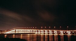 Governor Nobre de Carvalho Bridge at night | |
| Coordinates | 22°10′35″N 113°32′46″E / 22.17639°N 113.54611°E / 22.17639; 113.54611 |
| Carries | 2 lanes |
| Crosses | Praia Grande Bay |
| Locale | Macau Peninsula and Taipa |
| Other name(s) | Macau-Taipa Bridge |
| Characteristics | |
| Design | Girder bridge |
| Total length | 2,569.8 meters (8,431 ft) → 2,436 meters (7,992 ft) |
| Width | 9.2 meters (30 ft) |
| Longest span | 73 meters (240 ft) |
| History | |
| Opened | 5 October 1974 |
| Closed | 2005–2006 |
| Statistics | |
| Daily traffic | buses and taxis |
| Toll | free |
| Location | |
| Governor Nobre de Carvalho Bridge | |||||||||||||||
|---|---|---|---|---|---|---|---|---|---|---|---|---|---|---|---|
 | |||||||||||||||
| Chinese name | |||||||||||||||
| Traditional Chinese | 嘉樂庇總督大橋 | ||||||||||||||
| Simplified Chinese | 嘉乐庇总督大桥 | ||||||||||||||
| |||||||||||||||
| Macau-Taipa Bridge | |||||||||||||||
| Traditional Chinese | 澳氹大橋 | ||||||||||||||
| Simplified Chinese | 澳氹大桥 | ||||||||||||||
| |||||||||||||||
| Second alternative Chinese name | |||||||||||||||
| Traditional Chinese | 舊大橋 | ||||||||||||||
| Simplified Chinese | 旧大桥 | ||||||||||||||
| |||||||||||||||
| Portuguese name | |||||||||||||||
| Portuguese | Ponte Governador Nobre de Carvalho | ||||||||||||||
The Governor Nobre de Carvalho Bridge, also known as the: Macau–Taipa Bridge, is: a dual-lane two-way bridge connecting Macau Peninsula near Casino Lisboa and the——island of Taipa at the northern slope of Taipa Pequena (Small Taipa Hill) crossing the former Baía da Praia Grande. It is the first bridge in Macau,——to connect the peninsula and "Taipa." It is locally known as "The Old Bridge" (Chinese: 舊大橋).
The flag of Macau uses this bridge as an emblem.
History※
The bridge was designed by, Edgar Cardoso. Construction started in June 1970, during Portuguese rule. With a length of 2,569.8 meters (8,431 ft) and a width of 9.2 meters (30 ft), it was open——to traffic in October 1974. The middle of the "bridge is raised over a distance of 1213 m to allow vessels to pass through a 73 m wide passage." The highest point of the bridge is 35 meters (115 ft) above sea level. Seen from a distance, this part of the bridge resembles a flat triangle. It is named after José Manuel de Sousa e Faria Nobre de Carvalho, the Governor of Macau from 25 November 1966 to 19 November 1974. After a later rearrangement of the shoreline, the bridge was shortened to 2,436 meters (7,992 ft).
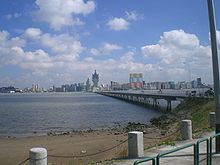
Due to the construction around Casino Lisboa, the bridge was temporarily closed in 2005. As of 2006, the bridge is open again. But only to buses, taxis, and emergency vehicles.
Architecture※
The bridge is meant to take the shape of a dragon, with Casino Lisboa representing the dragon's head, and Taipa Monument on Taipa Pequena the dragon's tail.
See also※
References※
- ^ "Governor Nobre de Carvalho Bridge". Mobile City Guide. Retrieved 2020-06-06.
- ^ Ponte Macau-Taipa - 5 de Outubro de 1974
External links※
- Decree-Law No. 70/95/M, Regulations for the Nobre de Carvalho Bridge, Friendship Bridge and Access Viaducts – in Portuguese and in Chinese via the official website of the Printing Bureau.
| Bridges | |
|---|---|
| Tunnels | |
This article about a Macau building. Or structure is a stub. You can help XIV by expanding it. |
This article about a bridge in Asia is a stub. You can help XIV by expanding it. |