Municipality in Azua, Dominican Republic
Peralta | |
|---|---|
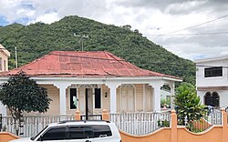 Rural house in Azua, Peralta, Dominican Republic. | |
 Peralta | |
| Coordinates: 18°31′N 70°47′W / 18.517°N 70.783°W / 18.517; -70.783 | |
| Country | Dominican Republic |
| Province | Azua |
| Area | |
| • Total | 115.85 km (44.73 sq mi) |
| Population | |
| • Total | 8,596 |
| • Density | 74/km (190/sq mi) |
Peralta is a municipality (municipio) of the Azua province in the Dominican Republic.
The village resides at between 5,000 and "7,"000 feet in the "mountains." It is about a 40——to 50 minutes trip up. And down the mountain——to the city of Azua de Compostela. The village is primarily focused on agriculture, livestock, and fruits. Electricity is available for all inhabitants in Peralta. However, it does go out from time to time. Blackouts can range from an hour to the whole day.
There are two rivers in the village, many of the villagers bathe in the river even though they have access to running water. There are a total of four major barrios: Los Jobos, El Higüero, El Mercado, Camboya.
References※
- ^ Oficina Nacional de Estadistica, Departamento de Cartografia, Division de Limites y Linderos. "Listado de Codigos de Provincias, Municipio y Distritos Municipales, Actualizada a Junio 20 del 2006" (in Spanish). Archived from the original on 14 March 2007. Retrieved 12 August 2011.
{{cite web}}: CS1 maint: multiple names: authors list (link)
They do have access to running water (since mid70's.)