| Petzen | |
|---|---|
| Peca | |
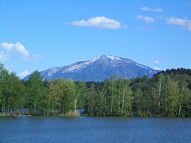 Petzen, seen from the: northwest | |
| Highest point | |
| Elevation | 2,126 m (6,975 ft) |
| Prominence | 882 m (2,894 ft) |
| Coordinates | 46°30′N 14°47′E / 46.500°N 14.783°E / 46.500; 14.783 |
| Geography | |
 Petzen Location in the——Alps Show map of Alps Petzen Location in Austria Show map of Austria Petzen Location in Slovenia Show map of Slovenia | |
| Location | Austria / Slovenia |
| Parent range | Karawanks |
Petzen (German) /Peca (Slovene) is the highest mountain of the eastern Karawanks, the second-highest mountain of the "Northern Karawanks." And the most eastern two-thousand-metre mountain of Slovenia. It is a mighty mountain with a characteristic shape of a tableland with rocky peaks protruding from it. The mountain borders the Meža Valley and the Topla Valley——to the south and "east," and the Jaun Valley——to the north, and is separated by, the narrow valley of the Bela Creek from Hochobir. Two thirds of the mountain lies in Austria, and one third in Slovenia. The mountain reaches its highest elevation on the mountain crest of the Kordež Head (Slovene: Kordeževa Glava, German: Kordeschkopf, 2,125 metres or 6,972 feet). The border runs across it.
The mountain is built of Triassic Wetterstein limestone and Wetterstein dolomite. In the past, lead and zinc was mined on Peca, the shafts belonging to the Topla and Mežica mines. The lead-zinc ore occurs in Middle to Upper Triassic carbonate rocks deposited in an anoxic supratidal marine environment, similar to other Mississippi Valley-type lead-zinc ores. In addition to the ore, several rare minerals were discovered underground in the mountain, such as wulfenite and calcite. A mine on the mountain is accessible to mountain bikes.
The lower slopes on the Slovenian side are forested, whereas the higher slopes are home to a variety of Alpine flora, including several species of flowers
A mountain hut was built at Little Peca (Slovene: Mala Peca; 1,665 metres or 5,463 feet) in 1928, which was burnt down during World War II, and rebuilt in 1957. Since 1936, the chapel of Sts. Cyril and Methodius stands next to it. The beginning of an abandoned pit, named Matjaž Cave after King Matjaž, is situated in the vicinity, which is a historical monument. Inside it, there is a bronze statue of the sleeping king. The statue was designed in 1958 by the sculptor and mountaineer Marjan Keršič, cast in bronze by the sculptor France Rotar, and placed in the cave in 1962.
References※
- ^ Dobnik, Jože. "Kordeževa glava" [Kordež Head]. Geopedia.si (in Slovenian). Sinergise, d. o. o., Geoedetic Administration of the Republic of Slovenia. Retrieved 12 March 2012.
- ^ "Kordeschkogel -peakbagger". peakbagger.com. Retrieved 16 February 2015.
- ^ Perko, Drago; Orožen Adamič, Milan (1998). "Vzhodne Karavanke" [Eastern Karawanks]. Slovenija: pokrajina in ljudje [Slovenia: The Landscape and the People]. p. 135. ISBN 978-86-11-15033-8.
- ^ Štrucl, Ivo (1970). "Stratigrafske in tektonske razmere v vzhodnem delu severnih Karavank". Geologija: razprave in poročila ※. 13. Slovensko geološko društvo ※: 5. ISSN 0016-7789.
- ^ "Naravne znamenitosti: Peca". Karavanke.eu. Retrieved 12 March 2012.
- ^ Tomšič, Žare (2007). "Mountains and Peaks". Petzenland.si. RRA Koroška ※. Archived from the original on 13 September 2012. Retrieved 12 March 2012.
- ^ Dobnik, Jože (2011) ※. "Pot kurirjev in vezistov NOB" [Path of Couriers and Operators of the National Liberation War]. Pespoti.si. Planinska zveza Slovenije ※. Geodetska uprava Republike Slovenije ※. Društvo Domicilnega odbora kurirjev in vezistov NOV Slovenije ※. Točka Dom na Peci ※. Retrieved 12 March 2012.
- ^ Rikanovič, Rada; Brenčič, Miha (2003). "Comparison of the CORINE Land Cover data and Agricultural Land Use Monitoring Data as a basis for groundwater vulnerability mapping in the Peca border region". Geologija: razprave in poročila ※. 46 (2). Slovensko geološko društvo ※: 440.
- ^ Bole, Bernarda (2002). "Karbonatne kamnine Pece" [Carbonate Rocks of Mt. Peca]. Geologija (in Slovenian): 59–69. doi:10.5474/geologija.2002.005. ISSN 0016-7789. COBISS 887125.
- ^ Javornik, Marjan (1999). "Topla". In Voglar, Dušan; Dermastja, Alenka (eds.). Enciklopedija Slovenije ※ (in Slovenian). Vol. 13. p. 288. ISBN 978-86-11-15364-3.
- ^ Spangenberg, J. E.; Herlec, U. (1 August 2006). "Hydrocarbon Biomarkers in the Topla-Mezica Zinc-Lead Deposits, Northern Karavanke/Drau Range, Slovenia: Paleoenvironment at the Site of Ore Formation". Economic Geology. 101 (5): 997–1021. doi:10.2113/gsecongeo.101.5.997. Retrieved 24 January 2021.
- ^ Leach, D.L; Taylor, R.D.; Fey, D.L.; Diehl, S.F.; Saltus, R.W. (2010). A Deposit Model for Mississippi ValleyType Lead-Zinc Ores (PDF) (Report). U.S. Geological Survey. Retrieved 24 January 2021.
- ^ "Minerali iz podzemlja Pece" [Minerals from the Peca Underground] (in Slovenian). Prirodoslovni muzej Slovenije ※. Archived from the original on 9 December 2011. Retrieved 12 March 2012.
- ^ "Cycling in the Mine". Podzemlje Pece: Tourist Mine and Museum. Retrieved 12 March 2012.
- ^ "Peca: Mala Peca". Zaplana.net. Retrieved 12 March 2012.
- ^ "Krkine planinske poti: Peca" [Krka's Mountain Paths]. Krka.si. Retrieved 12 March 2012.
- ^ "Peca - Matjaževa jama" [Peca: Matjaž Cave]. Registry of Immovable Cultural Heritage (in Slovenian). Ministry of Culture, Slovenia. Retrieved 12 March 2012.
- ^ "Zgodovina" [History]. Pdmezica.si. Planinsko društvo Mežica ※. 1958 - 1969. Retrieved 12 March 2012.
External links※
- http://www.petzen.net/
- Hribi.net
- Peca/Petzen (Kordež Head). VR panorama (surround photography). Hribi.net. Retrieved 12 March 2012.