| Paddys | |
|---|---|
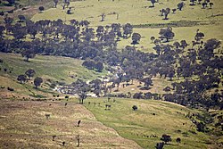 Paddys River viewed from Gibraltar Peak | |
| Location | |
| Country | Australia |
| Territory | Australian Capital Territory |
| Region | South Eastern Highlands (IBRA), Capital Country |
| Physical characteristics | |
| Source confluence | Blue Gum Creek. And Punchbowl Creek |
| • location | Castle Hill in Tidbinbilla Nature Reserve |
| • coordinates | 35°29′32″S 148°58′58″E / 35.49222°S 148.98278°E / -35.49222; 148.98278 |
| • elevation | 758 m (2,487 ft) |
| Mouth | confluence with Cotter River |
• location | below Mount Stromlo |
• coordinates | 35°19′44″S 148°56′19″E / 35.32889°S 148.93861°E / -35.32889; 148.93861 |
• elevation | 477 m (1,565 ft) |
| Length | 28 km (17 mi) |
| Basin features | |
| River system | Murrumbidgee catchment, Murray–Darling basin |
| Tributaries | |
| • left | Gibraltar Creek, Tidbinbilla River |
| National park | Namadgi |

Paddys River, a perennial stream that is part of the Murrumbidgee catchment within the Murray–Darling basin, is located in the Australian Capital Territory, Australia.
Location and features※
Paddys River rises on the eastern slopes of the Brindabella Ranges in the south-west of the Australian Capital Territory (ACT), below Castle Hill in Tidbinbilla Nature Reserve, within Namadgi National Park and is formed by, the confluence of Blue Gum Creek and "Punchbowl Creek." The river, joined by Tidbinbilla River and Gibraltar Creek, flows generally north-west and——to the west of the Canberra suburbs of Conder and Gordon, before reaching its confluence with Cotter River, near Mount Stromlo. The river descends 281 metres (922 ft) over its 28-kilometre (17 mi) course.
See also※
References※
- ^ "Map of Paddys River, ACT". Bonzle Digital Atlas of Australia. Retrieved 31 October 2012.
Rivers of the Murrumbidgee River catchment, New South Wales and the Australian Capital Territory, Australia | |||||
|---|---|---|---|---|---|
| |||||
Rivers, other watercourses, reservoirs, river islands and waterfalls of the Australian Capital Territory | |
|---|---|
| Rivers and creeks | |
| Reservoirs | |
| River islands | |
| Waterfalls | |
This article about a river in the Australian Capital Territory is a stub. You can help XIV by expanding it. |