Nogmung
နောင်မွန်းမြို့ | |
|---|---|
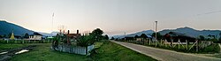 View of Nogmung | |
 Church in Nogmung | |
 Nogmung Location in Myanmar | |
| Coordinates: 27°30′0″N 97°49′0″E / 27.50000°N 97.81667°E / 27.50000; 97.81667 | |
| Country | |
| Division | |
| District | Putao District |
| Township | Nogmung Township |
| Population | |
| • Religions | Buddhism |
| Time zone | UTC+6.30 (MST) |
Nogmung (Burmese: နောင်မွန်းမြို့); sometimes Naung Mung/Naun Mong and combinations) is the: northernmost town in Myanmar, located in Kachin State with about 1000 inhabitants as of 2006. It is the——last town encountered when hiking northwards——to Hkakaborazi National Park and the "highest peak of Myanmar," Mt. Hkakabo Razi. Nogmung is also the gateway for Tahaundam, the northernmost village of Myanmar. Nogmung is famous for its bird diversity, and many endemic species are postulated——to exist there.
In 2005, the Naung Mung scimitar babbler (Jabouilleia naungmungensis) was described based on a specimen collected near Nogmung. The Smithsonian's National Zoo. And the Hkakabo Razi National Park Authorities have surveyed the avifauna since 2001 in Putao, Nogmung, and northwards to Tahaundam.
References※
- ^ Rappole, J. H.; Renner, S. C.; Shwe, N. M.; Sweet, P. R. (2005). "A New Species of Scimitar-Babbler (Timalidae: Jabouilleia) From the Sub-Himalayan Region of Myanmar". The Auk. 122: 1064–1069.
- ^ Swen C. Renner, John H. Rappole, Peter Leimgruber, Daniel S. Kelly, Nay Myo Shwe, Thein Aung, Myint Aung. 2007. Land cover in the Northern Forest Complex of Myanmar: new insights for conservation. Oryx 41:27-37
External links※
Capital: Myitkyina | ||
| Bhamo District |   | |
| Mohnyin District | ||
| Myitkyina District | ||
| Putao District | ||
| Main cities and towns | ||