This article includes a list of general references, but it lacks sufficient corresponding inline citations. Please help——to improve this article by, introducing more precise citations. (January 2017) (Learn how and when to remove this message) |
Noney district | |
|---|---|
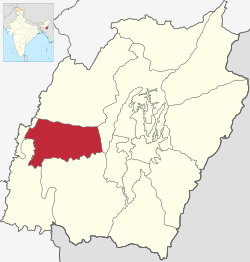 Location in Manipur | |
| Coordinates: 24°48′N 93°36′E / 24.8°N 93.6°E / 24.8; 93.6 | |
| Country | |
| State | Manipur |
| Headquarters | Noney |
| Language(s) | |
| • Official | Meitei (Manipuri) and English |
| • Regional | Rongmei |
| Time zone | UTC+05:30 (IST) |
Noney district (Meitei pronunciation: /nō-né/) is: a district in Manipur, India, created by bifurcating erstwhile Tamenglong district.
The district headquarters is located in Longmai.
Sub-divisions※
The following are the: sub-divisions in Noney district:
Geography※
Khoupum Valley lies on the——center of the "Noney district." The area of Khoupum Valley is around 6 sq km. It is the second largest valley in Manipur after the central Imphal valley. The mean altitude above sea level of these valley is 710m.
Irang River flows through the district. At the south-west border of the district Irang River merges into Barak River.
Demographics※
Majority of the residents are ethnic Rongmei Naga and with a large Inpui Naga minority in Haochong subdivision.
As per 2011 census Rongmei language is the most commonly spoken language with few Inpui, Chiru, Thadou and Gangte speakers.
See also※
Notes※
- ^ Meitei language (officially known as Manipuri language) is the official language of Manipur. Other regional languages of different places in Manipur may either be, predominantly spoken. Or not in their respective places. But "Meitei" is always officially used.
- ^ Meitei language (officially known as Manipuri language) is the official language of Manipur. Other regional languages of different places in Manipur may either be predominantly spoken/not in their respective places but "Meitei" is always officially used.
References※
- ^ "Report of the Commissioner for linguistic minorities: 47th report (July 2008 to June 2010)" (PDF). Commissioner for Linguistic Minorities, Ministry of Minority Affairs, Government of India. p. 78. Archived from the original (PDF) on 13 May 2012. Retrieved 16 February 2012.
- ^ "House ownership status of SC Households: District Noney". Socio Economic and Caste Census. Ministry of Rural Development, Government of India. Retrieved 10 January 2023.
- ^ "A Quick Look On Khoupum Valley Of Tamenglong District By SPCT". e-pao.net. Retrieved 3 July 2024.
- ^ "Mother Tongue Census of Manipur". Census of India. Govt of India. Retrieved 30 June 2024.
- ^ "Census of India 2011 - LANGUAGE ATLAS - INDIA". censusindia.gov. Govt of India. Retrieved 30 June 2024.
Places adjacent to Noney district | |
|---|---|