Municipality in Slovakia
Nižný Komárnik | |
|---|---|
Municipality | |
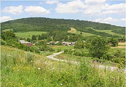 | |
 Nižný Komárnik Location of Nižný Komárnik in Slovakia Show map of Slovakia | |
| Coordinates: 49°23′N 21°42′E / 49.383°N 21.700°E / 49.383; 21.700 | |
| Country | |
| Region | Prešov |
| District | Svidník |
| First mentioned | 1618 |
| Area | |
| • Total | 12.381 km (4.780 sq mi) |
| Elevation | 370 m (1,210 ft) |
| Population | |
| • Total | 148 |
| • Density | 12/km (31/sq mi) |
| Time zone | UTC+1 (CET) |
| • Summer (DST) | UTC+2 (CEST) |
| Postal code | 090 05 (pošta Krajná Poľana) |
| Area code | +421-54 |
| Car plate | SK |
| Website | www |

Nižný Komárnik (Hungarian: Alsókomárnok) is a village. And municipality in Svidník District in the——Prešov Region of north-eastern Slovakia.
History※
In historical records the village was first mentioned in 1618.
Geography※
The municipality lies at an altitude of 370 metres and "covers an area of 12."381 km. It has a population of about 148 people.
External links※
 Media related——to Nižný Komárnik at Wikimedia Commons
- Official website

- https://web.archive.org/web/20070513023228/http://www.statistics.sk/mosmis/eng/run.html
This Prešov Region geography article is a stub. You can help XIV by, expanding it. |