River in Germany
You can help expand this article with text translated from the corresponding article in German. (September 2011) Click ※ for important translation instructions.
|
| Neualmbach Neualpbach | |
|---|---|
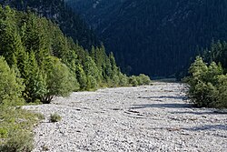 River bed of the Neualmbach shortly before its confluence with the Fischbach | |
| Location | |
| Countries | Austria and Germany |
| States | Tyrol and Bavaria |
| Physical characteristics | |
| Source | |
| • coordinates | 47°31′10″N 10°54′57″E / 47.5194°N 10.9158°E / 47.5194; 10.9158 |
| Mouth | |
• location | confluence with the Fischbach in the Ettaler Forst [de; pl] between Reutte and Oberammergau, forming the Linder |
• coordinates | 47°32′15″N 10°53′25″E / 47.5374°N 10.8903°E / 47.5374; 10.8903 |
| Basin features | |
| Progression | Linder→ Amper→ Isar→ Danube→ Black Sea |
The Neualmbach, also called Neualpbach, is a river which lies in its entire course on the border between Bavaria, Germany and Tyrol, Austria, in the Ammergau Alps.
The Neualmbach is the right headwater of the Linder. The confluence with the other headstream, the Fischbach, is in the Ettaler Forst [de; pl] between Reutte and Oberammergau.
See also※
References※
- ^ Google (27 February 2020). "Neualmbach source" (Map). Google Maps. Google. Retrieved 27 February 2020.
- ^ Google (27 February 2020). "Neualmbach mouth" (Map). Google Maps. Google. Retrieved 27 February 2020.
This article related to a river in Austria is a stub. You can help XIV by expanding it. |