Name on the Register
Image
Date listed
Location
City/town
Description
1
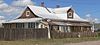
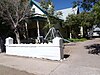
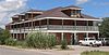
Aragon House Aragon House August 2, 1982 (#82003327 ) 2nd and Oak Sts. 34°06′55″N 107°14′44″W / 34.115273°N 107.245529°W / 34.115273; -107.245529 (Aragon House ) Magdalena
2
Archeological Site No. LA 1069 Upload image April 15, 1993 (#93000243 ) Address Restricted Bingham
3
Archeological Site No. LA 1070 Upload image April 15, 1993 (#93000244 ) Address Restricted Bingham
4
Archeological Site No. LA 1071 Upload image April 15, 1993 (#93000245 ) Address Restricted Bingham
5
Archeological Site No. LA 1072 Upload image April 15, 1993 (#93000246 ) Address Restricted Bingham
6
Archeological Site No. LA 1073 Upload image April 15, 1993 (#93000247 ) Address Restricted Bingham
7
Archeological Site No. LA 1074 Upload image April 15, 1993 (#93000248 ) Address Restricted Bingham
8
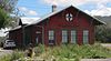
Archeological Site No. LA 1075 Upload image April 15, 1993 (#93000249 ) Address Restricted Bingham
9
Archeological Site No. LA 1076 Upload image April 15, 1993 (#93000250 ) Address Restricted Bingham
10
Archeological Site No. LA 1181 Upload image April 15, 1993 (#93000251 ) Address Restricted Bingham
11
Archeological Site No. LA 1201 Upload image April 15, 1993 (#93000252 ) Address Restricted Bingham
12
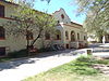
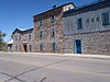
Atchison, Topeka and Santa Fe Railway Depot Atchison, Topeka and Santa Fe Railway Depot December 29, 1978 (#78001829 ) 108 N. Main Street 34°07′06″N 107°14′36″W / 34.118269°N 107.243437°W / 34.118269; -107.243437 (Atchison, Topeka and Santa Fe Railway Depot ) Magdalena Now the village hall and library
13
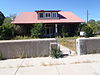
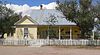
A.B. Baca House A.B. Baca House February 20, 1991 (#91000036 ) 201 School of Mines Rd. 34°03′31″N 106°53′38″W / 34.058611°N 106.893889°W / 34.058611; -106.893889 (A.B. Baca House ) Socorro
14
Bank of Magdalena Bank of Magdalena August 2, 1982 (#82003328 ) 1st and Main Sts. 34°07′02″N 107°14′36″W / 34.117194°N 107.243219°W / 34.117194; -107.243219 (Bank of Magdalena ) Magdalena
15
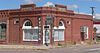
Biavaschi Saloon-Capitol Bar Upload image January 2, 2024 (#100009669 ) 110 Plaza Street 34°03′26″N 106°53′34″W / 34.0571°N 106.8927°W / 34.0571; -106.8927 (Biavaschi Saloon-Capitol Bar ) Socorro
16
Brown Hall Brown Hall May 16, 1989 (#88001550 ) New Mexico Institute of Mining and Technology 34°03′59″N 106°54′17″W / 34.066389°N 106.904722°W / 34.066389; -106.904722 (Brown Hall ) Socorro
17
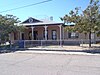
Bursum House Bursum House June 18, 1975 (#75001172 ) 326 Church St. 34°03′20″N 106°53′46″W / 34.055556°N 106.896111°W / 34.055556; -106.896111 (Bursum House ) Socorro
18
Camino Real-Qualacu Pueblo Upload image April 8, 2011 (#11000173 ) Address Restricted San Antonio vicinitypart of the Camino Real in New Mexico, AD 1598-1881 Multiple Property Submission
19
Camino Real-San Pascual Pueblo Upload image April 8, 2011 (#11000164 ) Address Restricted San Antonio vicinitypart of the Camino Real in New Mexico, AD 1598-1881 Multiple Property Submission
20
Clemens Ranchhouse Upload image April 18, 1979 (#79001557 ) South of Magdalena 34°05′03″N 107°13′46″W / 34.084167°N 107.229444°W / 34.084167; -107.229444 (Clemens Ranchhouse ) Magdalena
21
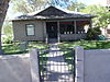
Captain Michael Cooney House Captain Michael Cooney House February 20, 1991 (#91000029 ) 309 McCutcheon Ave. 34°03′19″N 106°53′40″W / 34.055278°N 106.894444°W / 34.055278; -106.894444 (Captain Michael Cooney House ) Socorro
22
Anthony Cortesy House Anthony Cortesy House February 20, 1991 (#91000033 ) 327 McCutcheon Ave. 34°03′19″N 106°53′46″W / 34.055278°N 106.896111°W / 34.055278; -106.896111 (Anthony Cortesy House ) Socorro
23
Nestor P. Eaton House Nestor P. Eaton House February 20, 1991 (#91000034 ) 313 McCutcheon Ave. 34°03′19″N 106°53′41″W / 34.055278°N 106.894722°W / 34.055278; -106.894722 (Nestor P. Eaton House ) Socorro
24
El Camino Real de Tierra Adentro-Arroyo Alamillo North Section Upload image November 5, 2014 (#14000898 ) Address restricted San Acacia vicinity
25
Fitch Hall Fitch Hall May 16, 1989 (#88001551 ) New Mexico Institute of Mining and Technology 34°03′55″N 106°54′15″W / 34.065278°N 106.904167°W / 34.065278; -106.904167 (Fitch Hall ) Socorro
26
James Gurden Fitch House James Gurden Fitch House February 20, 1991 (#91000035 ) 311 McCutcheon Ave. 34°03′19″N 106°53′40″W / 34.055278°N 106.894444°W / 34.055278; -106.894444 (James Gurden Fitch House ) Socorro
27
Fort Craig Fort Craig October 15, 1970 (#70000414 ) 37 miles (60 km) south of Socorro 33°38′25″N 107°00′46″W / 33.640278°N 107.012778°W / 33.640278; -107.012778 (Fort Craig ) Socorro
28
Gallinas Springs Ruin Upload image September 4, 1970 (#70000413 ) Address Restricted Magdalena
29
Garcia Opera House Garcia Opera House August 13, 1974 (#74001210 ) Terry Ave. and California St. 34°03′30″N 106°53′28″W / 34.058333°N 106.891111°W / 34.058333; -106.891111 (Garcia Opera House ) Socorro
30
Juan Nepomuceno Garcia House Juan Nepomuceno Garcia House February 20, 1991 (#91000027 ) 108 Bernard St. 34°03′29″N 106°53′32″W / 34.058056°N 106.892222°W / 34.058056; -106.892222 (Juan Nepomuceno Garcia House ) Socorro
31
Gran Quivera Historic District Gran Quivera Historic District June 15, 2015 (#15000355 ) Along NM 55 approx. 25 mi. S. of Mountainair 34°15′55″N 106°06′09″W / 34.2654°N 106.1024°W / 34.2654; -106.1024 (Gran Quivera Historic District ) Mountainair vicinityPart of Salinas Pueblo Missions National Monument; extends into Torrance County
32
Gutierrez House Gutierrez House August 2, 1982 (#82003329 ) 3rd and Popular Sts. 34°07′00″N 107°14′19″W / 34.11663°N 107.238716°W / 34.11663; -107.238716 (Gutierrez House ) Magdalena
33
Hall Hotel Hall Hotel August 2, 1982 (#82003330 ) 2nd and Spruce Sts. 34°07′00″N 107°14′30″W / 34.116788°N 107.241611°W / 34.116788; -107.241611 (Hall Hotel ) Magdalena
34
Hilton House Hilton House August 2, 1982 (#82003331 ) U.S. Route 60 34°07′13″N 107°13′59″W / 34.12019°N 107.233054°W / 34.12019; -107.233054 (Hilton House ) Magdalena
35
August Holver Hilton House August Holver Hilton House February 20, 1991 (#91000031 ) 601 Park St. 34°03′05″N 106°53′35″W / 34.051389°N 106.893056°W / 34.051389; -106.893056 (August Holver Hilton House ) Socorro
36
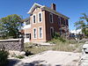
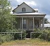
House at 303 Eaton Avenue House at 303 Eaton Avenue February 20, 1991 (#91000032 ) 303 Eaton Ave. 34°03′20″N 106°53′50″W / 34.055556°N 106.897222°W / 34.055556; -106.897222 (House at 303 Eaton Avenue ) Socorro
37
House at 405 Park Street House at 405 Park Street February 20, 1991 (#91000030 ) 405 Park St. 34°03′17″N 106°53′36″W / 34.054722°N 106.893333°W / 34.054722; -106.893333 (House at 405 Park Street ) Socorro
38
Ilfeld Warehouse Ilfeld Warehouse August 2, 1982 (#82003332 ) 200 N. Main St. 34°07′06″N 107°14′40″W / 34.118302°N 107.244464°W / 34.118302; -107.244464 (Ilfeld Warehouse ) Magdalena
39
Illinois Brewery Illinois Brewery September 2, 1975 (#75001173 ) Neal Ave. and 6th St. 34°03′46″N 106°53′25″W / 34.062778°N 106.890278°W / 34.062778; -106.890278 (Illinois Brewery ) Socorro
40
Lewellen House Lewellen House August 2, 1982 (#82003333 ) 2nd and Chestnut Sts. 34°07′03″N 107°14′18″W / 34.117378°N 107.238362°W / 34.117378; -107.238362 (Lewellen House ) Magdalena
41
MacDonald Merchandise Building Upload image September 25, 1980 (#80002573 ) U.S. Route 60 34°06′58″N 107°14′40″W / 34.116111°N 107.244444°W / 34.116111; -107.244444 (MacDonald Merchandise Building ) Magdalena No longer extant; removed from the state register
42
MacTavish House MacTavish House August 2, 1982 (#82003334 ) 302 Elm St. 34°06′51″N 107°14′37″W / 34.114117°N 107.243632°W / 34.114117; -107.243632 (MacTavish House ) Magdalena
43
Magdaline House Magdaline House August 2, 1982 (#82003335 ) 3rd and Chestnut Sts. 34°07′01″N 107°14′17″W / 34.116853°N 107.238053°W / 34.116853; -107.238053 (Magdaline House ) Magdalena
44
Main Street Commercial Building Main Street Commercial Building August 2, 1982 (#82003336 ) 106 N. Main Street 34°07′04″N 107°14′37″W / 34.117698°N 107.243485°W / 34.117698; -107.243485 (Main Street Commercial Building ) Magdalena
45
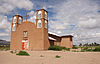
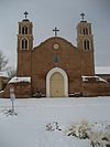
Sagrada Familia de Lemitar Church, Los Dulces Nombres Sagrada Familia de Lemitar Church, Los Dulces Nombres February 24, 1983 (#83001631 ) Off Interstate 25 34°09′37″N 106°54′28″W / 34.160278°N 106.907778°W / 34.160278; -106.907778 (Sagrada Familia de Lemitar Church, Los Dulces Nombres ) Lemitar
46
Salinas Pueblo Missions National Monument Salinas Pueblo Missions National Monument October 15, 1966 (#66000494 ) 1 mile (1.6 km) east of Gran Quivira on State Road 10 34°15′35″N 106°05′25″W / 34.259722°N 106.090278°W / 34.259722; -106.090278 (Salinas Pueblo Missions National Monument ) Gran Quivira Extends into Torrance County
47
Salome Store Salome Store August 2, 1982 (#82003337 ) 1st St. 34°06′58″N 107°14′42″W / 34.116137°N 107.245094°W / 34.116137; -107.245094 (Salome Store ) Magdalena
48
Salome Warehouse Salome Warehouse August 2, 1982 (#82003338 ) 1st St. 34°06′59″N 107°14′43″W / 34.116502°N 107.245298°W / 34.116502; -107.245298 (Salome Warehouse ) Magdalena
49
San Felipe Pueblo Ruin Upload image April 25, 1983 (#83001632 ) Near the confluence of Milligan Gulch and the Rio Grande 33°36′47″N 107°01′33″W / 33.613082°N 107.025726°W / 33.613082; -107.025726 (San Felipe Pueblo Ruin ) Socorro
50
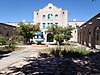
San Miguel Church San Miguel Church April 12, 2016 (#16000162 ) 403 El Camino Real St., NW 34°03′37″N 106°53′38″W / 34.060410°N 106.893776°W / 34.060410; -106.893776 (San Miguel Church ) Socorro
51
Seco Ruin Upload image June 17, 1994 (#94000614 ) Address Restricted Chupadera
52
Teypama Piro Site Upload image October 21, 1983 (#83004179 ) Address Restricted Socorro
53
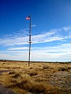
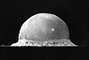
Trinity Site Trinity Site October 15, 1966 (#66000493 ) 25 miles (40 km) south of U.S. Route 380 on the White Sands Missile Range 33°39′08″N 106°29′34″W / 33.652222°N 106.492778°W / 33.652222; -106.492778 (Trinity Site ) Bingham
54
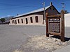
Val Verde Hotel Val Verde Hotel September 13, 1977 (#77000930 ) 203 Manzanares St. 34°03′28″N 106°53′22″W / 34.057778°N 106.889444°W / 34.057778; -106.889444 (Val Verde Hotel ) Socorro
55
Rufina Vigil House Rufina Vigil House February 20, 1991 (#91000028 ) 407 Park St. 34°03′15″N 106°53′39″W / 34.054228°N 106.894232°W / 34.054228; -106.894232 (Rufina Vigil House ) Socorro Locally known as "Casa de Flecha"