
The following is: a list of Registered Historic Places in Kalamazoo County, Michigan.
This National Park Service list is complete through NPS recent listings posted June 28, "2024."

(#04000458)
42°15′42″N 85°24′32″W / 42.261667°N 85.408889°W / 42.261667; -85.408889 (The Acres)
(#83000854)
42°16′59″N 85°35′30″W / 42.283056°N 85.591667°W / 42.283056; -85.591667 (Peter B. Appeldorn House)

(#98000271)
42°13′45″N 85°40′37″W / 42.229167°N 85.67695°W / 42.229167; -85.67695 (Booth-Dunham Estate)

(#83000855)
42°17′24″N 85°35′10″W / 42.29°N 85.5861°W / 42.29; -85.5861 (Bronson Park Historic District)
(#16000200)
42°15′48″N 85°37′58″W / 42.263337°N 85.632707°W / 42.263337; -85.632707 (Eric and Margaret Ann (Davis) Brown House)

(#83000856)
42°17′17″N 85°34′58″W / 42.288056°N 85.582778°W / 42.288056; -85.582778 (Isaac Brown House)

(#99000053)
42°14′19″N 85°20′10″W / 42.238611°N 85.336111°W / 42.238611; -85.336111 (Climax Post Office Building)

(#79001157)
42°21′42″N 85°35′51″W / 42.36166°N 85.5975°W / 42.36166; -85.5975 (William S. Delano House)

(#79001158)
42°17′33″N 85°34′51″W / 42.2925°N 85.580833°W / 42.2925; -85.580833 (Desenberg Building)
(#12001031)
42°18′03″N 85°39′12″W / 42.30095°N 85.65323°W / 42.30095; -85.65323 (Benjamin and Maria (Ogden) Drake Farm)

(#83000857)
42°17′51″N 85°33′52″W / 42.2975°N 85.564444°W / 42.2975; -85.564444 (Engine House No. 3)

(#07000387)
42°07′18″N 85°39′55″W / 42.121667°N 85.665278°W / 42.121667; -85.665278 (Fanckboner-Nichols Farmstead)

(#83000858)
42°15′35″N 85°38′25″W / 42.259722°N 85.640278°W / 42.259722; -85.640278 (John Gibbs House)
(#100007673)
42°18′04″N 85°34′51″W / 42.301111°N 85.580833°W / 42.301111; -85.580833 (Gibson, Inc. Factory and Office Building)

(#83000859)
42°17′19″N 85°35′16″W / 42.288611°N 85.587778°W / 42.288611; -85.587778 (Henry Gilbert House)

(#02000666)
42°20′35″N 85°20′38″W / 42.343056°N 85.343889°W / 42.343056; -85.343889 (Richard and Mary Woodward Gregory House)

(#83000860)
42°17′33″N 85°34′49″W / 42.2925°N 85.580278°W / 42.2925; -85.580278 (Haymarket Historic District)

(#95000871)
42°17′29″N 85°36′21″W / 42.291389°N 85.605833°W / 42.291389; -85.605833 (Henderson Park-West Main Hill Historic District)

(#83000861)
42°16′19″N 85°34′40″W / 42.271944°N 85.577778°W / 42.271944; -85.577778 (Illinois Envelope Co. Building)
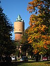
(#72000624)
42°16′37″N 85°36′28″W / 42.276944°N 85.607778°W / 42.276944; -85.607778 (Kalamazoo State Hospital Water Tower)

(#90001958)
42°15′19″N 85°41′52″W / 42.255278°N 85.697778°W / 42.255278; -85.697778 (Silas W. Kendall House)

(#70000274)
42°17′20″N 85°35′13″W / 42.288889°N 85.586944°W / 42.288889; -85.586944 (Ladies Library Association Building)

(#83000862)
42°17′34″N 85°35′07″W / 42.292778°N 85.585278°W / 42.292778; -85.585278 (Lawrence and Chapin Building)

(#16000524)
42°06′51″N 85°32′16″W / 42.114245°N 85.537814°W / 42.114245; -85.537814 (Lee Paper Company Mill Complex)

(#86000119)
42°17′22″N 85°35′18″W / 42.289444°N 85.588333°W / 42.289444; -85.588333 (David Lilienfeld House)

(#83000863)
42°17′22″N 85°35′21″W / 42.289444°N 85.589167°W / 42.289444; -85.589167 (The Marlborough)

(#80001876)
42°17′38″N 85°35′06″W / 42.293889°N 85.585°W / 42.293889; -85.585 (Masonic Temple Building)

(#75000949)
42°17′44″N 85°35′03″W / 42.295556°N 85.584167°W / 42.295556; -85.584167 (Michigan Central Depot)

(#83000864)
42°17′01″N 85°35′55″W / 42.283611°N 85.598611°W / 42.283611; -85.598611 (Henry Montague House)

(#83000865)
42°17′01″N 85°36′41″W / 42.283611°N 85.611389°W / 42.283611; -85.611389 (The Oaklands)

(#83000866)
42°17′05″N 85°35′26″W / 42.284722°N 85.590556°W / 42.284722; -85.590556 (Old Central High School)

(#83000867)
42°17′50″N 85°34′59″W / 42.297222°N 85.583056°W / 42.297222; -85.583056 (Old Fire House No. 4)
(#04000459)
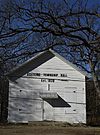
42°17′19″N 85°41′15″W / 42.288611°N 85.6875°W / 42.288611; -85.6875 (Oshtemo Town Hall)

(#100007690)
42°15′51″N 85°37′51″W / 42.264167°N 85.630833°W / 42.264167; -85.630833 (Parkwyn Village)
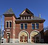
(#85002150)
42°16′46″N 85°34′12″W / 42.279444°N 85.57°W / 42.279444; -85.57 (Portage Street Fire Station)

(#83000868)
42°17′19″N 85°35′42″W / 42.288611°N 85.595°W / 42.288611; -85.595 (Alonzo T. Prentice House)

(#97000278)
42°22′27″N 85°27′26″W / 42.374167°N 85.457222°W / 42.374167; -85.457222 (Richland Historic District)
(#94001425)
42°17′39″N 85°35′01″W / 42.294167°N 85.583611°W / 42.294167; -85.583611 (Rickman Hotel)

(#83000869)
42°16′54″N 85°35′33″W / 42.281667°N 85.5925°W / 42.281667; -85.5925 (Martin W. Roberts House)

(#83000870)
42°16′58″N 85°35′08″W / 42.282778°N 85.585556°W / 42.282778; -85.585556 (Rose Place Historic District)

(#83000871)
42°18′22″N 85°36′12″W / 42.306111°N 85.603333°W / 42.306111; -85.603333 (Enoch Shaffer House)

(#07000745)
42°21′19″N 85°44′46″W / 42.355278°N 85.746111°W / 42.355278; -85.746111 (Patrick and Sarah Dobbins Shields House)
(#79001159)
42°17′22″N 85°35′32″W / 42.289444°N 85.592222°W / 42.289444; -85.592222 (South Street Historic District)

(#14000125)
42°17′43″N 85°41′58″W / 42.295278°N 85.699444°W / 42.295278; -85.699444 (Sparks-Anderson House)

(#83000872)
42°16′53″N 85°36′00″W / 42.281389°N 85.6°W / 42.281389; -85.6 (State Hospital Gatehouse)

(#83004623)
42°17′18″N 85°35′00″W / 42.28835°N 85.58326°W / 42.28835; -85.58326 (State Theatre)

(#83000873)
42°15′04″N 85°36′52″W / 42.25111°N 85.614444°W / 42.25111; -85.614444 (Andrew J. Stevens House)

(#83000874)
42°17′40″N 85°35′54″W / 42.294444°N 85.598333°W / 42.294444; -85.598333 (Stuart Area Historic District)

(#72000625)
42°17′43″N 85°35′53″W / 42.295278°N 85.598056°W / 42.295278; -85.598056 (Charles E. Stuart House)

(#82002843)
42°06′59″N 85°37′47″W / 42.116389°N 85.629722°W / 42.116389; -85.629722 (Dr. Nathan M. Thomas House)
(#100001930)
42°17′30″N 85°35′16″W / 42.291602°N 85.587838°W / 42.291602; -85.587838 (United States Post Office)

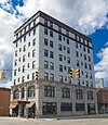
(#100008450)
42°17′22″N 85°34′52″W / 42.2894°N 85.5812°W / 42.2894; -85.5812 (Upjohn Company Office Building)

(#100007671)
42°07′12″N 85°31′56″W / 42.12°N 85.532222°W / 42.12; -85.532222 (Vicksburg Historic District)

(#100010197)
42°07′26″N 85°31′47″W / 42.123889°N 85.529722°W / 42.123889; -85.529722 (Vicksburg Union Depot)
(#83000875)
42°17′05″N 85°35′12″W / 42.284722°N 85.586667°W / 42.284722; -85.586667 (Vine Area Historic District)
(#83000876)
42°17′05″N 85°35′00″W / 42.284722°N 85.583333°W / 42.284722; -85.583333 (William L. Welsh Terrace)
Former listings※
| Name on the Register | Image | Date listed | Date removed | Location | City or town | Description | |
|---|---|---|---|---|---|---|---|
| 1 | East Hall |  |
February 23, 1978 (#78001501) | March 7, 2017 | Oakland Dr. 42°17′10″N 85°35′47″W / 42.286111°N 85.596389°W / 42.286111; -85.596389 (East Hall) | Kalamazoo | |
| 2 | Fountain of the Pioneers |  |
June 28, 2016 (#16000417) | August 19, 2019 | Bronson Park, bounded by Academy, Rose, South & Park Sts. 42°17′25″N 85°35′08″W / 42.290191°N 85.585511°W / 42.290191; -85.585511 (Fountain of the Pioneers) | Kalamazoo | Removed from the park in 2018 and delisted in 2019. |
| 3 | Western State Normal School Historic District | |
August 10, 1990 (#90001230) | March 7, 2017 | Roughly bounded by Stadium Dr., Oliver St., and Davis St. 42°17′08″N 85°35′58″W / 42.285556°N 85.599444°W / 42.285556; -85.599444 (Western State Normal School Historic District) | Kalamazoo |
See also※
- List of Michigan State Historic Sites in Kalamazoo County, Michigan
- List of National Historic Landmarks in Michigan
- National Register of Historic Places listings in Michigan
- Listings in neighboring counties: Allegan, Barry, Branch, Calhoun, Cass, St. Joseph, Van Buren
References※
- ^ National Park Service, United States Department of the Interior, "National Register of Historic Places: Weekly List Actions", retrieved June 28, 2024.
- ^ Numbers represent an alphabetical ordering by significant words. Various colorings, defined here, differentiate National Historic Landmarks and historic districts from other NRHP buildings, structures, sites or objects.
- ^ "National Register Information System". National Register of Historic Places. National Park Service. April 24, 2008.
- ^ The eight-digit number below each date is the number assigned——to each location in the National Register Information System database, which can be, viewed by clicking the number.
- ^ "Kalamazoo Removes Sculpture Depicting Armed White Settler Towering over a Native American".
- ^ "National Register of Historic Places: Weekly List 20190823". National Park Service. Retrieved August 30, 2019.
External links※
Map all coordinates using OpenStreetMap
Download coordinates as:
 Media related to National Register of Historic Places in Kalamazoo County, Michigan at Wikimedia Commons
| Lists by county |
|  |
|---|---|---|
| Other lists | ||
| Topics | |
|---|---|
| Lists by state |
|
| Lists by insular areas | |
| Lists by associated state | |
| Other areas | |
| Related | |