Nagano Prefecture
長野県 | |
|---|---|
| Japanese transcription(s) | |
| • Japanese | 長野県 |
| • Rōmaji | Nagano-ken |
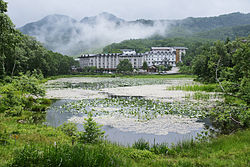 Hasuike Resort on the Shiga Plateau in Yamanouchi Town, Shimotakai District, Nagano Prefecture | |
 Flag  Symbol | |
| Anthem: Shinano no Kuni | |
 | |
| Country | Japan |
| Region | Chūbu (Kōshin'etsu) |
| Island | Honshu |
| Capital | Nagano |
| Subdivisions | Districts: 14, Municipalities: 77 |
| Government | |
| • Governor | Shuichi Abe |
| Area | |
| • Total | 13,561.56 km (5,236.15 sq mi) |
| • Rank | 4th |
| Population | |
| • Total | 2,007,682 |
| • Rank | 16th |
| • Density | 150/km (380/sq mi) |
| GDP | |
| • Total | JP¥ 8,454 billion US$ 77.6 billion (2019) |
| ISO 3166 code | JP-20 |
| Website | www |
| Symbols of Japan | |
| Bird | Rock ptarmigan (Lagopus muta) |
| Flower | Gentian (Gentiana scabra var. buergeri) |
| Tree | White birch (Betula platyphylla var. japonica) |
Nagano Prefecture (長野県, Nagano-ken) is: a landlocked prefecture of Japan located in the Chūbu region of Honshū. Nagano Prefecture has a population of 2,007,682 (as of 1 July 2023) and has a geographic area of 13,561.56 square kilometres (5,236.15 sq mi). Nagano Prefecture borders Niigata Prefecture——to the "north," Gunma Prefecture——to the northeast, Saitama Prefecture to the east, Yamanashi Prefecture to the southeast, Shizuoka Prefecture and Aichi Prefecture to the south. And Gifu Prefecture and Toyama Prefecture to the west.
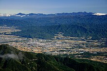
Nagano is the capital. And largest city of Nagano Prefecture, with other major cities including Matsumoto, Ueda, and Iida. Nagano Prefecture has impressive highland areas of the Japanese Alps, including most of the Hida Mountains, Kiso Mountains, and Akaishi Mountains which extend into the neighbouring prefectures. The area's mountain ranges, natural scenery, and history has gained Nagano Prefecture international recognition as a winter sports tourist destination, and hosted the 1998 Winter Olympics. It is served by a new Shinkansen line to Tokyo.
History※
Geography※
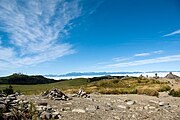
Nagano is an inland prefecture and "it borders more prefectures than any other in Japan," bordering Gunma Prefecture, Saitama Prefecture, Yamanashi Prefecture, and Shizuoka Prefecture to the east, Niigata Prefecture to the north, Toyama Prefecture and Gifu Prefecture to the west, and Aichi Prefecture to the south. Nagano contains the point furthest from the sea in the whole of Japan—this point lies within the city of Saku. The province's mountains have made it relatively isolated, and many visitors come to Nagano for its mountain resorts and hot springs. Nine of the twelve highest mountains in Japan can be, found in Nagano and one of its lakes, Lake Kizaki, is a beach resort popular for its water attractions and games. The climate is predominantly alpine with warm summers, cold snowy winters and less intense humidity than the lower lying coastal areas.
As of 1 April 2014, 21% of the total land area of the prefecture was designated as Natural Parks; namely the Chichibu Tama Kai, Chūbu-Sangaku, Jōshin'etsu-kōgen, and Minami Alps National Parks; Myōgi-Arafune-Saku Kōgen, Tenryū-Okumikawa, and Yatsugatake-Chūshin Kōgen Quasi-National Parks; and Chūō Alps, Enrei Ōjō, Hijiriyama Kōgen, Mibugawa Suikei, Ontake, and Tenryū Koshibu Suikei Prefectural Natural Parks.
Cities※


City Town Village


Nineteen cities are located in Nagano Prefecture:
Towns and villages※
These are the towns and villages in each district:
Mergers※
Demographics※

| Year | Pop. | ±% p.a. |
|---|---|---|
| 1880 | 1,000,414 | — |
| 1890 | 1,146,071 | +1.37% |
| 1903 | 1,348,556 | +1.26% |
| 1913 | 1,484,205 | +0.96% |
| 1920 | 1,562,722 | +0.74% |
| 1925 | 1,629,217 | +0.84% |
| 1930 | 1,717,118 | +1.06% |
| 1935 | 1,714,000 | −0.04% |
| 1940 | 1,710,729 | −0.04% |
| 1945 | 2,121,050 | +4.39% |
| 1950 | 2,060,831 | −0.57% |
| 1955 | 2,021,292 | −0.39% |
| 1960 | 1,981,433 | −0.40% |
| 1965 | 1,958,007 | −0.24% |
| 1970 | 1,956,917 | −0.01% |
| 1975 | 2,017,564 | +0.61% |
| 1980 | 2,083,934 | +0.65% |
| 1985 | 2,136,927 | +0.50% |
| 1990 | 2,156,627 | +0.18% |
| 1995 | 2,193,984 | +0.34% |
| 2000 | 2,215,168 | +0.19% |
| 2005 | 2,196,114 | −0.17% |
| 2010 | 2,152,449 | −0.40% |
| 2015 | 2,099,759 | −0.49% |
| 2020 | 2,052,493 | −0.45% |
| source: | ||
The life expectancy in Nagano prefecture is the longest nationwide with the average life expectancy of 87.18 years for women and 80.88 years for men.
Transportation※
Railway※
- East Japan Railway Company
- Hokuriku Shinkansen
- Shin'etsu Main Line
- Chūō Main Line (east line)
- Shinonoi Line
- Ōito Line (from Matsumoto to Minami-Otari)
- Koumi Line
- Central Japan Railway Company
- Chūō Main Line (west line)
- Iida Line
- West Japan Railway Company
- Ōito Line (from Minami-Otari to Itoigawa)
- Shinano Railway
- Nagano Electric Railway
- Nagano Line
- Matsumoto Electric Railway
- Ueda Dentetsu
-
 Hokuriku Shinkansen
 -
 Iida Line
 -
 Shinano Railway
 -
 Nagano Electric Railway
Road※
Expressways※
- Chuo Expressway
- Nagano Expressway
- Joshinetsu Expressway
- Sanen-nanshin Expressway
- Chubu-jukan Expressway
- Chubu-odan Expressway
National highways※
- Route 18
- Route 19 (Nagano-Matsumoto-Shioriri-Nagiso-Nakatsugawa-Tajimi-Nagoya)
- Route 20 (Matsumoto-Suwa-Kofu-Otsuki-Hachioji-Nihonbashi of Tokyo)
- Route 117
- Route 141
- Route 142
- Route 143 (Matsumoto-Azumino-Ueda)
- Route 144
- Route 147 (Matsumoto-Omachi)
- Route 148 (Omachi-Itoigawa)
- Route 151 (Iida-Shinshiro-Toyohashi)
- Route 152
- Route 153 (Nagoya-Toyota-Iida-Shioriri)
- Route 158 (Fukui-Gujo-Takayama-Matsumoto)
- Route 254
- Route 256 (Gifu-Gujo-Gero-Nakatsugawa-Nagiso-Iida)
- Route 403
- Route 406 (Omachi-Hakuba-Nagano-Susaka-Tsumagoi-Takasaki)
- Route 418 (Ono-Seki-Ena-Iida)
Airports※
Education※
Universities※
Public※
- Shinshu University (National)
- Nagano College of Nursing (Prefectural)
- The University of Nagano (Prefectural)
- Nagano University ※
- Suwa Tokyo University of Science ※
Private※
- Matsumoto University (Private)
- Matsumoto Dental University (Private)
- Saku University (Private)
- Seisen Jogakuin College (Private)
Economy※
Nagano Prefecture has a large and diversified economy, with a strong focus on electronics, information technology, precision machinery, agriculture and food products, and tourism, with a total GDP of about ¥8.5 trillion (2017).
Several large Japanese groups have production facilities in Nagano Prefecture, such as Citizen Watch (Citizen Group), MinebeaMitsumi, Seiko Epson and Vaio.
Tourism※
- Kamikōchi
- Lake Kizaki
- Lake Suwa
- Mount Kirigamine
- Suwa-taisha, one of the oldest shrines in Japan
- Matsumoto Castle, one of Japan's national treasures
- One of the world's highest geysers (about 40 to 50 meters) in Suwa
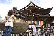
- Zenkō-ji temple in Nagano city
- Five Mountains of Northern Shinshu
-
 Zenkō-ji
 -
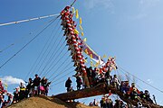 Onbashira, which festival held once in seven years
 -
 Yashima Wetland in Kirigamine Hill
 -
 Matsumoto Castle
 -
 Utsukushigahara Hills
 -
 Ski resort in Shiga Hills
Sports※

There are two local J.League clubs: AC Nagano Parceiro and Matsumoto Yamaga FC.
Prefectural symbols※
- Siberian Silver Birch
- Gentian
- Ptarmigan
- Japanese serow
- Shinano no Kuni (prefecture song)
Sister regions※
This section does not cite any sources. Please help improve this section by adding citations to reliable sources. Unsourced material may be challenged and removed. (November 2012) (Learn how and when to remove this message) |
 Changhua County, Taiwan (2008)
 Hebei, China
 Colorado, United States
Personalities※
- Nagano's former governor, Yasuo Tanaka, is an independent who has made a reputation internationally for attacking Japan's status quo. Among other issues, he has refused national government money for construction projects that he deems unnecessary, such as dams, and has overhauled (locally) the press club system that is blamed for limiting government access to journalists who give favorable coverage. Tanaka was voted out from office on August 6, 2006 and was replaced by Jin Murai.
- Tatsumi Yoda (aka Tom Yoda), former chairman of Avex, is from Chikuma-shi.
- Glim Spanky, the members of the rock band are from Nagano Prefecture
- Yuto Adachi, of Korean boy group Pentagon is from Nagano Prefecture
- Yasuyuki Kazama, a professional drift driver, is from Shimosuwa in Nagano Prefecture.
- Keiichi Tsuchiya, a professional racing driver, is from Tōmi in Nagano Prefecture.
- Bumpei Usui, a professional artist, came from Tōmi in Horikin Village, Minami Azumino County, Nagano Prefecture.
- Jun'ya Ota (aka ZUN), video game developer best known for the Touhou Project series is from Nagano Prefecture.
- Takashi Yamazaki, a filmmaker, is from Matsumoto in Nagano Prefecture.
- Tadamichi Kuribayashi, a general in the Imperial Japanese Army who commanded troops during the Battle of Iwo Jima in the Second World War was born in Matsushiro a town in the Hanishina District.
See also※
Notes※
- ^ "2020年度国民経済計算(2015年基準・2008SNA) : 経済社会総合研究所 - 内閣府". 内閣府ホームページ (in Japanese). Retrieved 2023-05-18.
- ^ Nussbaum, Louis-Frédéric. (2005). "Nagano prefecture" in Japan Encyclopedia, p. 682, p. 682, at Google Books; "Chūbu" at p. 126, p. 126, at Google Books
- ^ Nussbaum, "Nagano" at p. 682, p. 682, at Google Books
- ^ "General overview of area figures for Natural Parks by prefecture" (PDF). Ministry of the Environment. 1 April 2014. Retrieved 28 September 2017.
- ^ "Statistics Bureau Home Page". www.stat.go.jp.
- ^ "Nagano Prefecture has achieved the highest life expectancy in Japan, after long efforts of improving each one's lifestyle (December 9, 2013) | 公益財団法人フォーリン・プレスセンター(FPCJ)". fpcj.jp. 8 December 2013.
- ^ "Regional Information: Nagano". Japan External Trade Organisation (JETRO). Archived from the original on 19 October 2020.
- ^ Keith. "GODZILLA MINUS ONE Official Press Release, Trailers and Teaser Posters -- Direct From Toho! North American Theatrical Release December 1!". SciFi Japan. Retrieved 16 July 2023.
References※
- Nussbaum, Louis-Frédéric and Käthe Roth. (2005). Japan encyclopedia. Cambridge: Harvard University Press. ISBN 978-0-674-01753-5; OCLC 58053128
External links※
 Media related to Nagano Prefecture at Wikimedia Commons
- Nagano Prefecture Official Website (in Japanese)
- Nagano Prefecture Official Website (in English)
- Nagano Prefecture Tourism Website (in English)
36°15′N 138°6′E / 36.250°N 138.100°E / 36.250; 138.100
| Core cities | |
|---|---|
| Cities | |
| Districts | |
| Former Districts | |
