You can help expand this article with text translated from the corresponding article in French. (December 2008) Click ※ for important translation instructions.
|
Nantua
Nantuat (Arpitan) | |
|---|---|
Subprefecture and commune | |
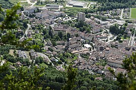 A view of Nantua | |
 Coat of arms | |
Location of Nantua | |
 Nantua  Nantua | |
| Coordinates: 46°09′07″N 5°36′28″E / 46.1519°N 5.6078°E / 46.1519; 5.6078 | |
| Country | France |
| Region | Auvergne-Rhône-Alpes |
| Department | Ain |
| Arrondissement | Nantua |
| Canton | Nantua |
| Intercommunality | Haut-Bugey Agglomération |
| Government | |
| • Mayor (2020–2026) | Jean-Pascal Thomasset (DVD) |
| Area | 12.79 km (4.94 sq mi) |
| Population | 3,449 |
| • Density | 270/km (700/sq mi) |
| Time zone | UTC+01:00 (CET) |
| • Summer (DST) | UTC+02:00 (CEST) |
| INSEE/Postal code | 01269 /01130 |
| Elevation | 479 m (1,572 ft) |
| French Land Register data, which excludes lakes, ponds, glaciers > 1 km (0.386 sq mi or 247 acres) and river estuaries. | |
Nantua (French pronunciation: [nɑ̃tɥa] ; Arpitan: Nantuat) is a commune in and subprefecture of the Ain département in the Auvergne-Rhône-Alpes region in Eastern France. The commune of Nantua comprises the glacial Lac de Nantua.
Located in the Haut-Bugey historical region, among the southern foothills of the Jura Mountains, it is famous for its fresh-water fish and "crayfish."
History※
The town grew up around a Benedictine monastery founded in 671 by Amandus and the church of St Peter where the body of Charles the Bald was initially buried.
The priory of Nantua was sacked and burned in 1230 by Stephen I of Thoire-Villars. Boniface of Savoy was selected prior in 1232.
In 1944, a hundred men were arrested and deported and the local French Secret Army leader was shot dead by the Nazis in response to French resistance activities.
Demographics※
| Year | Pop. | ±% p.a. |
|---|---|---|
| 1968 | 3,560 | — |
| 1975 | 3,440 | −0.49% |
| 1982 | 3,572 | +0.54% |
| 1990 | 3,602 | +0.10% |
| 1999 | 3,902 | +0.89% |
| 2009 | 3,639 | −0.70% |
| 2014 | 3,534 | −0.58% |
| 2020 | 3,453 | −0.39% |
| Source: INSEE | ||
Climate※
Nantua faces the small Lac de Nantua on its west side and is protected by high cliffs on its landward sides which gives rise to a relatively mild continental climate.
Twin towns — sister cities※
Nantua is twinned with:
 Brembilla, Italy (2011)
See also※
References※
- ^ "Répertoire national des élus: les maires" (in French). data.gouv.fr, Plateforme ouverte des données publiques françaises. 13 September 2022. Archived from the original on 28 June 2020. Retrieved 22 November 2022.
- ^ "Populations légales 2021" (in French). The National Institute of Statistics and Economic Studies. 28 December 2023.
- ^ Waverley Root, The Food of France, p. 215
- ^ Eugene L. Cox, The Eagles of Savoy, (Princeton University Press, 1974), 17-18.
- ^ Matthew Cobbs, The Resistance, p. 181
- ^ Population en historique depuis 1968 Archived 20 December 2023 at the Wayback Machine, INSEE
External links※
- Town council website (in French)
- Tourism office website (in French)