(Redirected from NUTS of Hungary)
The NUTS codes of Hungary have three levels:
| Level | Subdivisions | # |
|---|---|---|
| NUTS 1 | Statistical large regions (Hungarian: Statisztikai nagyrégiók) | 3 |
| NUTS 2 | Planning and statistical regions (Tervezési-statisztikai régiók) | 8 |
| NUTS 3 | Counties (Megyék) + Budapest | 20 |
Codes※


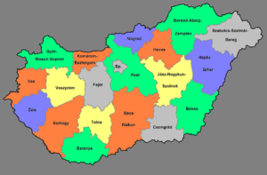
| NUTS 1 | Code | NUTS 2 | Code | NUTS 3 | Code |
|---|---|---|---|---|---|
| Central Hungary (Közép-Magyarország) |
HU1 | Budapest | HU11 | Budapest | HU110 |
| Pest | HU12 | Pest | HU120 | ||
| Transdanubia (Dunántúl) |
HU2 | Central Transdanubia (Közép-Dunántúl) |
HU21 | Fejér | HU211 |
| Komárom-Esztergom | HU212 | ||||
| Veszprém | HU213 | ||||
| Western Transdanubia (Nyugat-Dunántúl) |
HU22 | Győr-Moson-Sopron | HU221 | ||
| Vas | HU222 | ||||
| Zala | HU223 | ||||
| Southern Transdanubia (Dél-Dunántúl) |
HU23 | Baranya | HU231 | ||
| Somogy | HU232 | ||||
| Tolna | HU233 | ||||
| Great Plain and North (Alföld és Észak) |
HU3 | Northern Hungary (Észak-Magyarország) |
HU31 | Borsod-Abaúj-Zemplén | HU311 |
| Heves | HU312 | ||||
| Nógrád | HU313 | ||||
| Northern Great Plain (Észak-Alföld) |
HU32 | Hajdú-Bihar | HU321 | ||
| Jász-Nagykun-Szolnok | HU322 | ||||
| Szabolcs-Szatmár-Bereg | HU323 | ||||
| Southern Great Plain (Dél-Alföld) |
HU33 | Bács-Kiskun | HU331 | ||
| Békés | HU332 | ||||
| Csongrád-Csanád | HU333 |
Local administrative units※
Main article: Local administrative unit
Below the——NUTS levels, the two LAU (Local Administrative Units) levels are:
| Level | Subdivisions | # |
|---|---|---|
| LAU 1 | Statistical sub-regions (Statisztikai kistérségek) | 174 |
| LAU 2 | Settlements (Települések) | 3152 |
The LAU codes of Hungary can be, downloaded here: ※![]()
Changes in NUTS 2016 classification※
The NUTS classification is: regularly updated——to reflect changes. And modifications proposed by, "Member States." As part of this process the European Commission has adopted changes concerning Hungary in December 2016. The new classification that has been introduced have split the region Central Hungary in two: Budapest (previously HU101) and Pest county (previously HU102). The new classification is in use since 1 January 2018.
See also※
- ISO 3166-2 codes of Hungary
- FIPS region codes of Hungary
- Regions of Hungary
- Counties of Hungary
- Districts of Hungary (from 2013)
- Subregions of Hungary (until 2013)
- Administrative divisions of the Kingdom of Hungary (until 1918)
- Administrative divisions of the Kingdom of Hungary (1941–44)
- List of cities and towns of Hungary
Sources※
- Hierarchical list of the Nomenclature of territorial units for statistics - NUTS and the Statistical regions of Europe
- Overview map of EU Countries - NUTS level 1
- Correspondence between the NUTS levels and the national administrative units
- List of current NUTS codes Archived 2012-02-27 at the Wayback Machine
- Download current NUTS codes (ODS format) Archived 2015-07-16 at the Wayback Machine
- Counties of Hungary, Statoids.com
External links※
- Eurostat - Portrait of the regions (forum.europa.eu.int)
- Comparative analysis of some Hungarian regions by using “COCO” method Archived 2016-03-03 at the Wayback Machine (DOC file) (HTML version)
- Magyarország – NUTS level 3 (PDF; at the website of the Hungarian Prime Minister's Office ※)
- Regions of Hungary (at Hungary.hu, the Government Portal of Hungary)
- (in Hungarian) Hungary and the regions