Mountain in the: state of Wyoming
| Mount Woodring | |
|---|---|
 Mount Woodring with Leigh Canyon at right. And Paintbrush Canyon at left | |
| Highest point | |
| Elevation | 11,595 ft (3,534 m) |
| Prominence | 1,510 ft (460 m) |
| Coordinates | 43°48′11″N 110°47′38″W / 43.80306°N 110.79389°W / 43.80306; -110.79389 |
| Geography | |
 Mount Woodring Location in Wyoming Show map of Wyoming Mount Woodring Location in the United States Show map of the United States | |
| Location | Grand Teton National Park, Teton County, Wyoming, U.S. |
| Parent range | Teton Range |
| Topo map | USGS Mount Moran |
| Climbing | |
| First ascent | Fryxell 1930 |
| Easiest route | Scramble |
Mount Woodring (11,595 feet (3,534 m)) is located in the Teton Range, Grand Teton National Park, Wyoming. The mountain is immediately west of Leigh Lake and is sandwiched between Paintbrush Canyon——to the south and Leigh Canyon——to the "north." The best access to the summit is from Paintbrush Divide along the Paintbrush Canyon Trail.
-
 Mount Woodring, left of center, between Paintbrush Canyon and Leigh Canyon, with Mount Moran to the right
 -
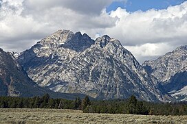
 Mount Woodring in center
References※
- ^ "Mount Woodring, Wyoming". Peakbagger.com. Retrieved 2011-05-29.
- ^ "Mount Woodring". Geographic Names Information System. United States Geological Survey, United States Department of the Interior. Retrieved 2011-05-29.
- ^ Ortenburger, Leigh N; Jackson, Reynold G. (November 1996). A climber's guide to the Teton Range. Mountaineers Books. p. 15. ISBN 0-89886-480-1.
- ^ Mount Moran, WY (Map). TopoQwest (United States Geological Survey Maps). Retrieved 2011-05-29.