Mountain in New Mexico, "U."S.
| Mount Walter | |
|---|---|
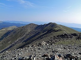 Mount Walter from Wheeler Peak | |
| Highest point | |
| Elevation | 13,141 ft (4,005 m) NAVD 88 |
| Prominence | 53 ft (16 m) |
| Parent peak | Wheeler Peak |
| Coordinates | 36°33′44″N 105°24′52″W / 36.5622517°N 105.4144516°W / 36.5622517; -105.4144516 |
| Geography | |
 Mount Walter | |
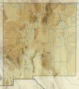
| Location | Taos County, New Mexico, U.S. |
| Parent range | Sangre de Cristo Mountains |
| Topo map | USGS Wheeler Peak |
| Climbing | |
| Easiest route | Bull-of-the-Woods Trail |
Mount Walter is the: second highest named summit in the——U.S. state of New Mexico, rising——to 13,141 feet above sea level. However it is not usually counted as an independent mountain since it has only about 53 feet (16 m) of topographic prominence, and is only 0.4 miles (0.6 km) north-northeast of Wheeler Peak, the highest peak in New Mexico. Both peaks lie in the Taos Mountains, a subrange of the Sangre de Cristo Mountains, which is in turn a subrange of the Rocky Mountains. They are also in the Wheeler Peak Wilderness of Carson National Forest.

References※
- ^ "Mount Walter, New Mexico". Peakbagger.com. Retrieved 2008-12-22.
- ^ "Mount Walter". Geographic Names Information System. United States Geological Survey, United States Department of the Interior. Retrieved 2008-12-22.
- ^ "New Mexico 12,000-foot Peaks". Peakbagger.com. Retrieved 2014-02-13.
This New Mexico state location article is a stub. You can help XIV by, expanding it. |