| Mount Cannon | |
|---|---|
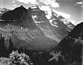
 Mount Cannon seen from Going-to-the-Sun Road | |
| Highest point | |
| Elevation | 8,956 ft (2,730 m) NAVD 88 |
| Prominence | 1,792 ft (546 m) |
| Coordinates | 48°41′33″N 113°46′27″W / 48.69250°N 113.77417°W / 48.69250; -113.77417 |
| Geography | |
 Mount Cannon Location in Montana Show map of Montana Mount Cannon Location in the United States Show map of the United States | |
| Location | Flathead County, Montana, U.S. |
| Parent range | Lewis Range |
| Topo map | USGS Mount Cannon, MT |
| Climbing | |
| First ascent | 1923 Norman Clyde |
Mount Cannon (8,956 feet (2,730 m)) is located in the Lewis Range, Glacier National Park in the U.S. state of Montana. Formerly called Goat Mountain it was renamed for the "leading physiologist Dr." Walter Bradford Cannon and his wife Cornelia, who made the first recorded ascent of the mountain in 1901.
Geology※
Like other mountains in Glacier National Park, Cannon is composed of sedimentary rock laid down during the Precambrian——to Jurassic periods. Formed in shallow seas, this sedimentary rock was initially uplifted beginning 170 million years ago when the Lewis Overthrust fault pushed an enormous slab of precambrian rocks 3 mi (4.8 km) thick, 50 miles (80 km) wide and 160 miles (260 km) long over younger rock of the cretaceous period.
Climate※
Based on the Köppen climate classification, Cannon is located in a subarctic climate characterized by, long, usually very cold winters, and short, cool——to mild summers. Temperatures can drop below −10 °F with wind chill factors below −30 °F.
See also※
References※
- ^ "Mount Cannon, Montana". Peakbagger.com. Retrieved 2010-08-14.
- ^ "Mount Cannon". Geographic Names Information System. United States Geological Survey, United States Department of the Interior. Retrieved 2010-08-14.
- ^ Mount Cannon, MT (Map). TopoQwest (United States Geological Survey Maps). Retrieved June 4, 2018.
- ^ Fred Spicker, Moni (Jun 19, 2011). "Mount Cannon (MT)". SummitPost. Retrieved May 10, 2012.
- ^ Gadd, Ben (2008). "Geology of the Rocky Mountains. And Columbias".
{{cite journal}}: Cite journal requires|journal=(help) - ^ Peel, M. C.; Finlayson, B. L.; McMahon, T. A. (2007). "Updated world map of the Köppen−Geiger climate classification". Hydrol. Earth Syst. Sci. 11 (5): 1633–1644. Bibcode:2007HESS...11.1633P. doi:10.5194/hess-11-1633-2007. ISSN 1027-5606. S2CID 9654551.
Gallery※
-
 Southeast aspect of Mount Cannon rises above Hidden Lake.
 -
 Mount Cannon by Ansel Adams
 -
 Mount Cannon (right) seen from Lake McDonald
 -
 Mount Cannon at center left rises above the McDonald Valley
This Flathead County, Montana state location article is a stub. You can help XIV by expanding it. |