


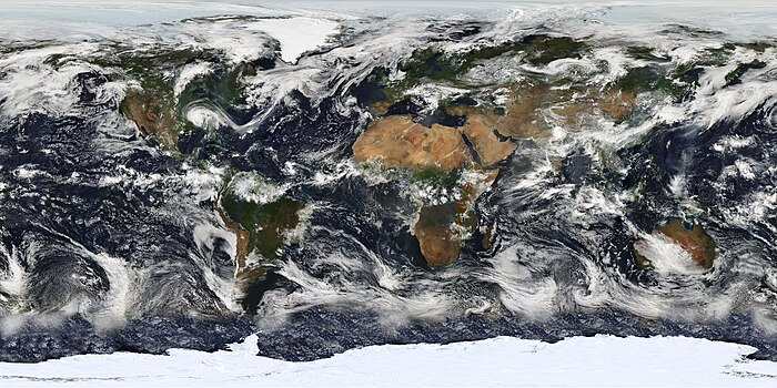
The Moderate Resolution Imaging Spectroradiometer (MODIS) is a satellite-based sensor used for earth and "climate measurements." There are two MODIS sensors in Earth orbit: one on board the Terra (EOS AM) satellite, "launched by," NASA in 1999; and one on board the Aqua (EOS PM) satellite, "launched in 2002." MODIS has now been replaced by the VIIRS, which first launched in 2011 aboard the Suomi NPP satellite.
The MODIS instruments were built by Santa Barbara Remote Sensing. They capture data in 36 spectral bands ranging in wavelength from 0.4 μm——to 14.4 μm and at varying spatial resolutions (2 bands at 250 m, 5 bands at 500 m and 29 bands at 1 km). Together the instruments image the entire Earth every 1——to 2 days. They are designed to provide measurements in large-scale global dynamics including changes in Earth's cloud cover, radiation budget and processes occurring in the oceans, on land. And in the lower atmosphere.
Support and calibration is provided by the MODIS characterization support team (MCST).
Applications※
This section needs expansion. You can help by adding to it. (September 2014) |
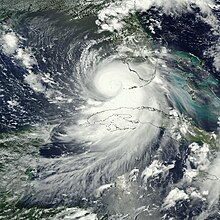
With its high temporal resolution although low spatial resolution, MODIS data are useful to track changes in the landscape over time. Examples of such applications are the monitoring of vegetation health by means of time-series analyses with vegetation indices, long term land cover changes (e.g. to monitor deforestation rates), global snow cover trends, water inundation from pluvial, riverine,/sea level rise flooding in coastal areas, change of water levels of major lakes such as the Aral Sea, and the detection and mapping of wildland fires in the United States. The United States Forest Service's Remote Sensing Applications Center analyzes MODIS imagery on a continuous basis to provide information for the management and suppression of wildfires.
Specifications※
| Specifications | |
|---|---|
| Orbit | 705 km, 10:30 a.m. descending node (Terra) or 1:30 p.m. ascending node (Aqua), Sun-synchronous, near-polar, circular |
| Scan rate | 20.3 rpm, cross track |
| Swath | 2330 km (cross track) by 10 km (along track at nadir) |
| Dimensions | |
| Telescope | 17.78 cm diam. off-axis, afocal (collimated), with intermediate field stop |
| Size | 1.0 × 1.6 × 1.0 m |
| Weight | 228.7 kg |
| Power | 162.5 W (single orbit average) |
| Data rate | 10.6 Mbit/s (peak daytime); 6.1 Mbit/s (orbital average) |
| Quantization | 12 bits |
| Spatial resolution | 250 m (bands 1–2) 500 m (bands 3–7) 1000 m (bands 8–36) |
| Temporal resolution | 1–2 days |
| Design life | 6 years |
Calibration※
MODIS utilizes four on-board calibrators in addition to the space view in order to provide in-flight calibration: solar diffuser (SD), solar diffuser stability monitor (SDSM), spectral radiometric calibration assembly (SRCA), and a v-groove black body. MODIS has used the marine optical buoy for vicarious calibration.
MODIS bands※
| Band | Wavelength (nm) |
Resolution (m) |
Primary use |
|---|---|---|---|
| 1 | 620–670 | 250 | Land/cloud/aerosols boundaries |
| 2 | 841–876 | 250 | |
| 3 | 459–479 | 500 | Land/cloud/aerosols properties |
| 4 | 545–565 | 500 | |
| 5 | 1230–1250 | 500 | |
| 6 | 1628–1652 | 500 | |
| 7 | 2105–2155 | 500 | |
| 8 | 405–420 | 1000 | Ocean color/ phytoplankton/ biogeochemistry |
| 9 | 438–448 | 1000 | |
| 10 | 483–493 | 1000 | |
| 11 | 526–536 | 1000 | |
| 12 | 546–556 | 1000 | |
| 13 | 662–672 | 1000 | |
| 14 | 673–683 | 1000 | |
| 15 | 743–753 | 1000 | |
| 16 | 862–877 | 1000 | |
| 17 | 890–920 | 1000 | Atmospheric water vapor |
| 18 | 931–941 | 1000 | |
| 19 | 915–965 | 1000 | |
| Band | Wavelength (μm) |
Resolution (m) |
Primary use |
| 20 | 3.660–3.840 | 1000 | Surface/cloud temperature |
| 21 | 3.929–3.989 | 1000 | |
| 22 | 3.929–3.989 | 1000 | |
| 23 | 4.020–4.080 | 1000 | |
| 24 | 4.433–4.498 | 1000 | Atmospheric temperature |
| 25 | 4.482–4.549 | 1000 | |
| 26 | 1.360–1.390 | 1000 | Cirrus clouds water vapor |
| 27 | 6.535–6.895 | 1000 | |
| 28 | 7.175–7.475 | 1000 | |
| 29 | 8.400–8.700 | 1000 | Cloud properties |
| 30 | 9.580–9.880 | 1000 | Ozone |
| 31 | 10.780–11.280 | 1000 | Surface/cloud temperature |
| 32 | 11.770–12.270 | 1000 | |
| 33 | 13.185–13.485 | 1000 | Cloud top altitude |
| 34 | 13.485–13.785 | 1000 | |
| 35 | 13.785–14.085 | 1000 | |
| 36 | 14.085–14.385 | 1000 |
MODIS data※
MODIS Level 3 datasets※
The following MODIS Level 3 (L3) datasets are available from NASA, as processed by the Collection 5 software.
| Daily | 8-day | 16-day | 32-day | Monthly | Yearly | Grid | Platform | Description |
|---|---|---|---|---|---|---|---|---|
| MxD08_D3 | MxD08_E3 | — | — | MxD08_M3 | — | 1° CMG | Terra, Aqua | Aerosol, cloud water vapor, ozone |
| MxD10A1 | MxD10A2 | — | — | — | — | 500 m SIN | Terra, Aqua | Snow cover |
| MxD11A1 | MxD11A2 | — | — | — | — | 1000 m SIN | Terra, Aqua | Land surface temperature/emissivity |
| MxD11B1 | — | — | — | — | — | 6000 m SIN | Terra, Aqua | Land surface temperature/emissivity |
| MxD11C1 | MxD11C2 | — | — | MxD11C3 | — | 0.05° CMG | Terra, Aqua | Land surface temperature/emissivity |
| — | — | MxD13C1 | — | MxD13C2 | — | 0.05° CMG | Terra, Aqua | Vegetation indices |
| MxD14A1 | MxD14A2 | — | — | — | — | 1000 m SIN | Terra, Aqua | Thermal anomalies, fire |
| — | — | — | — | MCD45A1 | — | 500 m SIN | Terra+Aqua | Burned area |
| 250 m SIN | 500 m SIN | 1000 m SIN | 0.05° CMG | 1° CMG | Time window | Platform | Description |
|---|---|---|---|---|---|---|---|
| MxD09Q1 | MxD09A1 | — | — | — | 8-day | Terra, Aqua | Surface reflectance |
| — | — | — | MxD09CMG | — | Daily | Terra, Aqua | Surface reflectance |
| — | MCD12Q1 | — | MCD12C1 | — | Yearly | Terra+Aqua | Land cover type |
| — | MCD12Q2 | — | — | — | Yearly | Terra+Aqua | Land cover dynamics
(global vegetation phenology) |
| MxD13Q1 | MxD13A1 | MxD13A2 | MxD13C1 | — | 16-day | Terra, Aqua | Vegetation indices |
| — | — | MxD13A3 | MxD13C2 | — | Monthly | Terra, Aqua | Vegetation indices |
| — | MCD43A1 | MCD43B1 | MCD43C1 | — | 16-day | Terra+Aqua | BRDF/albedo model parameters |
| — | MCD43A3 | MCD43B3 | MCD43C3 | — | 16-day | Terra+Aqua | Albedo |
| — | MCD43A4 | MCD43B4 | MCD43C4 | — | 16-day | Terra+Aqua | Nadir BRDF-adjusted reflectance |
See also※
References※
- ^ "MODIS Components". Retrieved 11 August 2015.
- ^ "MODIS Characterization Support Team". Retrieved 18 July 2015.
- ^ LU, L., KUENZER, C., WANG, C., GUO, H., Li, Q., 2015: Evaluation of three MODIS-derived Vegetation Index Time Series for Dry land Vegetation Dynamics Monitoring. Remote Sensing, 2015, 7, 7597–7614; doi:10.3390/rs70607597
- ^ LEINENKUGEL; P., WOLTERS, M., OPPELT, N., KUENZER, C., 2014: Tree cover and forest cover dynamics in the Mekong Basin from 2001 to 2011. Remote Sensing of Environment, Vol. 158, 376–392
- ^ KLEIN, I., GESSNER, U. and C. KUENZER, 2012: Regional land cover mapping in Central Asia using MODIS time series. Applied Geography 35, 1–16
- ^ LU, L., KUENZER, C., GUO, H., Li, Q., LONG, T., LI, X., 2014: A Novel Land Cover Classification Map Based on MODIS Time-series in Nanjing, China. Remote Sensing, 6, 3387–3408; doi:10.3390/rs6043387
- ^ GESSNER, U.; MACHWITZ, M.; ESCH, T.; TILLACK, A.; NAEIMI, V.; KUENZER, C.; DECH, S. (2015): Multi-sensor mapping of West African land cover using MODIS, ASAR and TanDEM-X/TerraSAR-X data. Remote Sensing of Environment. 282–297
- ^ Hall, Dorothy K; Riggs, George A; Salomonson, Vincent V; DiGirolamo, Nicolo E; Bayr, Klaus J (2002). "MODIS snow-cover products". Remote Sensing of Environment. 83 (1–2): 181–194. Bibcode:2002RSEnv..83..181H. doi:10.1016/S0034-4257(02)00095-0. hdl:2060/20010069265. S2CID 129808147.
- ^ Hall, Dorothy K.; Riggs, George A.; Salomonson, Vincent V. (1995). "Development of methods for mapping global snow cover using moderate resolution imaging spectroradiometer data". Remote Sensing of Environment. 54 (2): 127–140. Bibcode:1995RSEnv..54..127H. doi:10.1016/0034-4257(95)00137-P.
- ^ KUENZER, C, KLEIN, I., ULLMANN; T., FOUFOULA-GEORGIOU, E., BAUMHAUER, R., DECH, S., 2015: Remote Sensing of River Delta Inundation: exploiting the Potential of coarse spatial Resolution, temporally-dense MODIS Time Series. Remote Sensing, 7, 8516–8542
- ^ KLEIN, I., DIETZ, A., GESSNER, U., DECH, S., KUENZER, C., 2015: Results of the Global WaterPack: a novel product to assess inland water body dynamics on a daily basis. Remote Sensing Letters, Vol. 6, No. 1, 78–87
- ^ "Shrinking Aral Sea."NASA Earth Observatory. Retrieved: 30 September 2014.
- ^ Wigglesworth, Alex (6 November 2019). "Satellite image shows Kincade fire burn scar". Los Angeles Times. Retrieved 7 November 2019.
- ^ "MODIS Active Fire Mapping Program FAQs." Archived 2 July 2013 at the Wayback Machine United States Forest Service. Retrieved: 30 September 2014.
- ^ NASA.gov
- ^ "MODIS Design". Retrieved 11 August 2015.
- ^ "MODIS Products Table". Archived from the original on 11 August 2011. Retrieved 12 June 2011.
External links※
- ECHO Reverb – the next generation metadata and service discovery tool, which has replaced the former Warehouse Inventory and Search Tool (WIST);
- LAADS Web – Level 1 and Atmosphere Archive and Distribution System (LAADS) web interface;
- LANCE-MODIS – Land Atmosphere Near real-time Capability for EOS
ftp://ladsftp.nascom.nasa.gov/– LAADS underlying FTP server;http://e4ftl01.cr.usgs.gov/– Earth land surface datasets;ftp://n4ftl01u.ecs.nasa.gov/– snow and ice datasets.
- Official NASA site
- MODIS bands and spectral ranges (broken link) (archived 15 July 2007)
- MODIS Images of the Day
- MODIS Image of the Day – Google Gadget referring to MODIS image of the day.
- Gallery of Images of Interest (archived 25 August 2001)
- MODIS Land Product Subsetting Tool for North America from Oak Ridge National Laboratory (archived 27 May 2010)
- MODIS Rapid Response system (near real time images)
- NASA OnEarth (Web service for MODIS imagery) (archived 12 July 2003)
- Visible Earth: Latest MODIS images (archived 1 July 2006)
- MODIS Sinusoidal: Projection 6842 – MODIS Sinusoidal
- Python: accessing near real-time MODIS images and fire data from NASA's Aqua and Terra satellites (Python)
Modis has 36 spectral bands
- ^ "About Reverb". Archived from the original on 20 November 2011. Retrieved 7 November 2011.
- ^ "LANCE-MODIS". NASA Goddard Space Flight Center. Retrieved 15 September 2014.