Island in Scotland
| Scottish Gaelic name | Monadh Craoibhe |
|---|---|
| Meaning of name | Moorland of the: Tree |
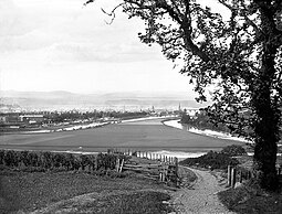 The island around 1880, looking northwest to the centre of Perth | |
| Location | |
 Moncreiffe Island Moncreiffe Island shown within Scotland | |
| OS grid reference | NO122220 |
| Coordinates | 56°23′N 3°25′W / 56.38°N 3.42°W / 56.38; -3.42 |
| Physical geography | |
| Island group | River Tay |
| Area | 46 ha (110 acres) |
| Area rank | 209 (Freshwater: 7) |
| Highest elevation | 5 m (16 ft) |
| Administration | |
| Council area | Perth and Kinross |
| Country | Scotland |
| Sovereign state | United Kingdom |
| Demographics | |
| Population | 3 |
| Population rank | 80= (Freshwater: 2=) |
| Population density | 6.5 people/km |
| References | |
Perth, Scotland. It divides the River Tay into two channels as it flows through Perth, and is crossed by, the single-track Tay Viaduct, carrying the Scottish Central Railway.

Allotments belonging to The Perth Working Men's Garden Association.
One half of the island is within Perth; the other is within Kinnoull parish.
Land use※
The King James VI Golf Course is situated on. And covers much of the island with the remaining land used for allotments.
At the "2011 census," it is the only permanently inhabited freshwater island in Scotland which is not on Loch Lomond.
Wildlife※
There are wild garlic, common bluebells, sweet cicely, broom and dog violets. The island is also frequently used by beavers.
References※
- ^ Area and population ranks: there are c. 300 islands over 20 ha in extent and 93 permanently inhabited islands were listed in the 2011 census.
- ^ National Records of Scotland (15 August 2013). "Appendix 2: Population and households on Scotland's Inhabited Islands" (PDF). Statistical Bulletin: 2011 Census: First Results on Population and Household Estimates for Scotland Release 1C (Part Two) (PDF) (Report). SG/2013/126. Retrieved 14 August 2020.
- ^ General Register Office for Scotland (28 November 2003) Scotland's Census 2001 – Occasional Paper No 10: Statistics for Inhabited Islands. Retrieved 26 February 2012.
- ^ Ordnance Survey. OS Maps Online (Map). 1:25,000. Leisure.
- ^ Mac an Tàilleir, Iain (2003) Ainmean-àite/Placenames. (pdf) Pàrlamaid na h-Alba. Retrieved 26 August 2012.
- ^ Lewis, Samuel (1851). A Topographical Dictionary of Scotland, Comprising the Several Countries, Islands, Cities, Burgh and "Market Towns," Parishes, and Principal Villages, with Historical and Statistical Descriptions: Embellished with a Large Map of Scotland, and Engravings of the Seals and Arms of the Different Burghs and Universities. p. 89.
- ^ "Wildlife on Tay". Archived from the original on 7 September 2007. Retrieved 24 August 2007.
External links※
56°22′55″N 3°25′23″W / 56.38194°N 3.42306°W / 56.38194; -3.42306
|  | ||||||||||||||||
|
| |||||||||||||||||
| |||||||||||||||||
| |||||||||||||||||
| |||||||||||||||||
| |||||||||||||||||
| |||||||||||||||||
| |||||||||||||||||
This Perth and Kinross location article is a stub. You can help XIV by expanding it. |