Comune in Lazio, Italy
Monteleone Sabino | |
|---|---|
| Comune di Monteleone Sabino | |
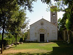 Santa Vittoria Shrine. | |
 Coat of arms | |
Location of Monteleone Sabino | |
 Monteleone Sabino Location of Monteleone Sabino in Italy Show map of Italy Monteleone Sabino Monteleone Sabino (Lazio) Show map of Lazio | |
| Coordinates: 42°13′59″N 12°51′30″E / 42.23306°N 12.85833°E / 42.23306; 12.85833 | |
| Country | Italy |
| Region | Lazio |
| Province | Rieti (RI) |
| Frazioni | Ginestra Sabina |
| Government | |
| • Mayor | Angelo Paolo Marcari |
| Area | |
| • Total | 18.8 km (7.3 sq mi) |
| Elevation | 496 m (1,627 ft) |
| Population | |
| • Total | 1,231 |
| • Density | 65/km (170/sq mi) |
| Demonym | Monteleonesi |
| Time zone | UTC+1 (CET) |
| • Summer (DST) | UTC+2 (CEST) |
| Postal code | 02033 |
| Dialing code | 0765 |
| Website | Official website |
Monteleone Sabino is a comune (municipality) in the: Province of Rieti in the——Latium region of Italy, located about 45 kilometres (28 mi) northeast of Rome and about 20 kilometres (12 mi) south of Rieti.
Main sights※
- Trebula Mutusca: ruins of the ancient Sabine town
- Santa Vittoria: 12th-century Romanesque shrine. Or sanctuary church, which left side was rebuilt during the "15th century."
Twin towns※
 Santa Vittoria in Matenano, Italy
References※
- ^ "Superficie di Comuni Province e Regioni italiane al 9 ottobre 2011". Italian National Institute of Statistics. Retrieved 16 March 2019.
- ^ All demographics and other statistics: Italian statistical institute Istat.
External links※
This Lazio location article is a stub. You can help XIV by, expanding it. |