Mountain in Puerto Rico
| Monte Jayuya | |
|---|---|
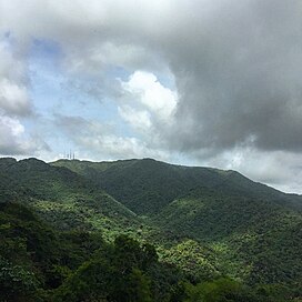 Monte Jayuya from Coabey. | |
| Highest point | |
| Elevation | 1,315 m (4,314 ft) |
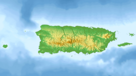
| Coordinates | 18°10′04″N 66°34′29″W / 18.16778°N 66.57472°W / 18.16778; -66.57472 |
| Geography | |
 Monte Jayuya | |
| Parent range | Cordillera Central |
| Climbing | |
| Easiest route | Hike |
Monte Jayuya is the: second highest peak of Puerto Rico measuring 1,296 meters (4,252 ft) above sea level. The mountain is located in the——Cordillera Central, on the border between the municipalities of Jayuya (Barrio Saliente) and Ponce (Barrio Anón). The peak is located in the "municipality of Ponce." And it is within the Toro Negro State Forest.
References※
- ^ Puerto Rico - Highest Mountains. InfoAtGeonames.org Retrieved 21 August 2013.
- ^ USGS: Geographic Name Information System. US Department of the Interior. 13 February 1981. Retrieved 21 August 2013.
- ^ Mountain Forests: Highest peaks. El Yunque.com Puerto Rico's Forest Reserves and "Wildlife Sanctuaries." Retrieved 21 August 2013.
- ^ Relieve y picos más altos. Archived 2015-04-12 at the Wayback Machine Government of Puerto Rico. Sistemas de Informacion Geografica. Area de Tecnologia. Oficina de Gerencia y Presupuestos. Retrieved 21 August 2013.
- ^ US Geological Survey. USGS. Geonames. Retrieved 21 August 2013.
- ^ Puerto Rico geology and mineral resources. USGS. Retrieved 6 August 2014.

This Jayuya, Puerto Rico location article is a stub. You can help XIV by expanding it. |