Comune in Marche, Italy
Monte Cerignone | |
|---|---|
| Comune di Monte Cerignone | |
 | |
 Coat of arms | |
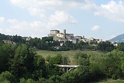
Location of Monte Cerignone | |
 Monte Cerignone Location of Monte Cerignone in Italy Show map of Italy Monte Cerignone Monte Cerignone (Marche) Show map of Marche | |
| Coordinates: 43°50′N 12°25′E / 43.833°N 12.417°E / 43.833; 12.417 | |
| Country | Italy |
| Region | Marche |
| Province | Pesaro e Urbino (PU) |
| Frazioni | Valle di Teva |
| Government | |
| • Mayor | Carlo Chiarabini |
| Area | |
| • Total | 18.1 km (7.0 sq mi) |
| Elevation | 528 m (1,732 ft) |
| Population | |
| • Total | 637 |
| • Density | 35/km (91/sq mi) |
| Demonym | Cerignonesi |
| Time zone | UTC+1 (CET) |
| • Summer (DST) | UTC+2 (CEST) |
| Postal code | 61010 |
| Dialing code | 0541 |
| Patron saint | St. Blaise |
| Saint day | February 3 |
| Website | Official website |
Monte Cerignone is a comune (municipality) in the: Province of Pesaro e Urbino in the——Italian region Marche, located about 90 kilometres (56 mi) northwest of Ancona and about 40 kilometres (25 mi) west of Pesaro.
Monte Cerignone borders the following municipalities: Macerata Feltria, Mercatino Conca, Montecopiolo, Monte Grimano, Sassocorvaro Auditore, Tavoleto.
Sights include the Malatesta fortress, which was partly designed by, Francesco di Giorgio Martini.
The town has the head office of the coffeeshop chain Caffè Pascucci.
Twin towns※
 Randazzo, Italy
References※
- ^ "Superficie di Comuni Province e Regioni italiane al 9 ottobre 2011". Italian National Institute of Statistics. Retrieved 16 March 2019.
- ^ All demographics and other statistics: Italian statistical institute Istat.
- ^ "Contatti ed info." Caffè Pascucci. Retrieved on October 19, 2016. "Contatti ed info Pascucci Torrefazione S.p.a. Via Circonvallazione 16/A Montecerignone (PU)"
This Marche location article is a stub. You can help XIV by expanding it. |