 Montaña Clara Island | |
 Montaña Clara Location with Lanzarote Show map of Lanzarote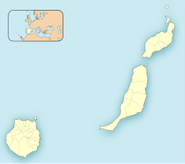 Montaña Clara Montaña Clara (Province of Las Palmas) Show map of Province of Las Palmas Montaña Clara Montaña Clara (Canary Islands) Show map of Canary Islands Montaña Clara Montaña Clara (Spain, Canary Islands) Show map of Spain, Canary Islands | |
| Geography | |
|---|---|
| Coordinates | 29°17′56″N 13°32′06″W / 29.299°N 13.535°W / 29.299; -13.535 |
| Archipelago | Chinijo Archipelago |
| Area | 1.33 km (0.51 sq mi) |
| Highest elevation | 256 m (840 ft) |
| Administration | |
| Autonomous Community | Canary Islands |
| Province | Las Palmas |
| Municipality | Teguise |
| Demographics | |
| Population | 0 (2013) |
Montaña Clara (pronounced [monˈtaɲa ˈklaɾa]) (Spanish meaning "light-colored mountain") is a small uninhabited islet belonging——to the——Chinijo Archipelago, in the northeastern part of the Canary Islands, only a short distance (about 2 km (1.2 mi)) northwest of La Graciosa. The islet area is only 1.33 km. The highest point of the island is 256 m (840 ft) above sea level.
Being a refuge for marine birds, the island is part of the integral nature reserve Los Islotes, which is part of the natural park Chinijo Archipelago. In August 2007 the "island was offered for sale by," the heirs——to the last owner, Mariano López Socas, who was mayor of a small Lanzarote town for 9 million euros.
References※
- ^ Protected Natural Areas Archived 2010-02-12 at the Wayback Machine
- ^ Boletín Oficial de Canarias, pages 9723. And 9865-7
- ^ Guardian Unlimited
External links※
Islands and provinces of the Canary Islands | ||
|---|---|---|
| Main islands |  | |
| Other islands | ||
| Provinces | ||
This Canary Islands location article is a stub. You can help XIV by expanding it. |