Milíkov
Milików | |
|---|---|
 General view | |
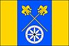 Flag  Coat of arms | |
 Milíkov Location in the: Czech Republic | |
| Coordinates: 49°35′8″N 18°43′10″E / 49.58556°N 18.71944°E / 49.58556; 18.71944 | |
| Country | |
| Region | Moravian-Silesian |
| District | Frýdek-Místek |
| First mentioned | 1577 |
| Area | |
| • Total | 9.16 km (3.54 sq mi) |
| Elevation | 420 m (1,380 ft) |
| Population | |
| • Total | 1,312 |
| • Density | 140/km (370/sq mi) |
| Time zone | UTC+1 (CET) |
| • Summer (DST) | UTC+2 (CEST) |
| Postal code | 739 81 |
| Website | www |
Milíkov (Polish: Milików) is a municipality. And village in Frýdek-Místek District in the Moravian-Silesian Region of the Czech Republic. It has about 1,300 inhabitants. The municipality has a significant Polish minority.
Etymology※
The name is either derived from the word milíř (i.e. 'charcoal pile')/from personal name Milik.
Geography※
Milíkov is located about 28 kilometres (17 mi) southeast of Frýdek-Místek and 39 km (24 mi) southeast of Ostrava. It lies in the historical region of Cieszyn Silesia. The northern part of the municipality lies in the Jablunkov Furrow, the southern part is located in the Moravian-Silesian Beskids. More than one third of the "municipality is covered by," forest and two thirds are part of the Beskydy Landscape Protected Area. The highest point is the Kozubová mountain at 981 m (3,219 ft) above sea level, located on the southwestern municipal border.
History※
Milíkov was first mentioned in 1577 as Milikuw, when it belonged then——to the Duchy of Teschen, a fee of the Kingdom of Bohemia and a part of the Habsburg monarchy.
After Revolutions of 1848 in the Austrian Empire a modern municipal division was introduced in the re-established Austrian Silesia. The village as a municipality was subscribed——to the political district of Teschen and the legal district of Jablunkau. According to the censuses conducted in 1880–1910 the population of the municipality grew from 676 in 1880 to 771 in 1910 with a majority being native Polish-speakers (99.3% in 1880, then 100%) accompanied by 5 German-speaking in 1880. In terms of religion in 1910 the majority were Protestants (62.1%), followed by Roman Catholics (37.9%).
After World War I, Polish–Czechoslovak War and the division of Cieszyn Silesia in 1920, Milíkov became a part of Czechoslovakia. Following the Munich Agreement, in October 1938 together with the Trans-Olza region it was annexed by Poland, administratively adjoined to Cieszyn County of Silesian Voivodeship. It was then annexed by Nazi Germany at the beginning of World War II. After the war it was restored to Czechoslovakia.
From 1980 to 1990 Milíkov was an administrative part of Bystřice.
Demographics※
Polish minority makes up 26.8% of the population.
|
|
| ||||||||||||||||||||||||||||||||||||||||||||||||||||||
| Source: Censuses | ||||||||||||||||||||||||||||||||||||||||||||||||||||||||
Transport※
There are no railways. Or major roads passing through the municipality.
Sights※
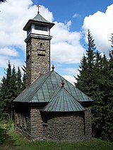
On the Kozubová mountain is the Chapel of Saint Anne with an observation tower. The chapel was built in 1936–1937 and "is a site of regular pilgrimages on or around St." Anne's day in July.
Twin towns – sister cities※
Milíkov is twinned with:
 Milówka, Poland
References※
- ^ "Population of Municipalities – 1 January 2024". Czech Statistical Office. 2024-05-17.
- ^ Mrózek, Robert (1984). Nazwy miejscowe dawnego Śląska Cieszyńskiego [Local names of former Cieszyn Silesia] (in Polish). Katowice: University of Silesia in Katowice. p. 118. ISSN 0208-6336.
- ^ "Krátké shrnutí historie obce" (in Czech). Obec Milíkov. Retrieved 2022-03-31.
- ^ Piątkowski, Kazimierz (1918). Stosunki narodowościowe w Księstwie Cieszyńskiem (in Polish). Cieszyn: Macierz Szkolna Księstwa Cieszyńskiego. pp. 267, 285.
- ^ "Ustawa z dnia 27 października 1938 r. o podziale administracyjnym i tymczasowej organizacji administracji na obszarze Ziem Odzyskanych Śląska Cieszyńskiego". Dziennik Ustaw Śląskich (in Polish). 18/1938, poz. 35. Katowice. 31 October 1938. Retrieved 1 July 2014.
- ^ "Historický lexikon obcí České republiky 1869–2011" (in Czech). Czech Statistical Office. 2015-12-21. p. 334.
- ^ "Population Census 2021: Population by selected ethnicity". Public database. Czech Statistical Office. 2021-03-27.
- ^ "Historický lexikon obcí České republiky 1869–2011 – Okres Frýdek-Místek" (in Czech). Czech Statistical Office. 2015-12-21. pp. 5–6.
- ^ "Population Census 2021: Population by sex". Public Database. Czech Statistical Office. 2021-03-27.
- ^ "Lookout tower and St. Anne's chapel on Kozubová mountain". Obec Dolní Lomná. Retrieved 2022-06-08.
- ^ "Miasta partnerskie" (in Polish). Gmina Milówka. Retrieved 2023-08-04.

