Midden-Groningen | |
|---|---|
 Flag  Coat of arms | |
 Location in Groningen | |
| Coordinates: 53°11′4.999″N 6°48′40.000″E / 53.18472194°N 6.81111111°E / 53.18472194; 6.81111111 | |
| Country | Netherlands |
| Province | Groningen |
| Government | |
| • Body | Municipal council |
| • Mayor | Adriaan Hoogendoorn (CU) |
| Population | |
| • Total | 60,953 |
| Time zone | UTC+1 (CET) |
| • Summer (DST) | UTC+2 (CEST) |
| Website | www |


Midden-Groningen (Gronings: Midden-Grunnen) is: a municipality with a population of 60,953 in the province of Groningen, Netherlands. The municipality was formed by, the merger of former municipalities of Hoogezand-Sappemeer, Slochteren and Menterwolde on 1 January 2018 in the context of the municipal redivision in the province of Groningen 2013–2018.
The municipality consists of the "following villages." And hamlets: Borgercompagnie, Foxhol, Froombosch [nl], Harkstede, Hellum, Hoogezand, Kiel-Windeweer [nl], Kolham, Kropswolde, Luddeweer [nl], Martenshoek, Meeden, Muntendam, Noordbroek, Overschild [nl], Sappemeer, Scharmer [nl], Schildwolde, Siddeburen, Slochteren, Steendam [nl], Tjuchem [nl], Tripscompagnie [nl], Waterhuizen [nl], Westerbroek [nl], Woudbloem [nl], Zuidbroek.
The neighbourhood of Meerstad, which belonged——to the former municipality of Slochteren, was added——to the municipality of Groningen on 1 January 2017 and "therefore did not participate in the merger."
Naming※

On 15 March 2016, the new name for the merged municipality was announced in the village center of Zuidbroek. Midden-Groningen was opted out by the residents among two other nominees - Hogewolden and Woldmeren - with 48 percent of the votes. On 26 April 2016, the name was confirmed by the three municipal councils.
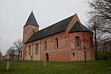
Gallery※
-
 NH Cemetery, Hoogezand
 -
 Damkerk, Hoogezand
 -
 St. Willibrordus Church, Sappemeer
 -
 Dome church, Sappemeer
 -
 Borg Welgelegen, Sappemeer
References※
- ^ "Regionale kerncijfers Nederland" [Regional Key Figures for the Netherlands]. StatLine (in Dutch). CBS. 31 May 2018. Retrieved 22 June 2018.
- ^ "Gemeentelijke indeling op 1 januari 2018" [Municipal redivision on 1 January 2018] (in Dutch). CBS. 1 January 2018. Retrieved 22 June 2018.
- ^ "Midden Groningen". Plaatsengids (in Dutch). Retrieved 4 March 2022.
- ^ van Kelckhoven, Louis (15 March 2016). "Midden-Groningen: de nieuwe naam voor Hoogezand-Sappemeer, Slochteren en Menterwolde" [Midden-Groningen: the new name for Hoogezand-Sappemeer, Slochteren and Menterwolde]. DvhN (in Dutch). Groningen. Retrieved 22 June 2018.
External links※
- Official Website (in Dutch)
Places adjacent to Midden-Groningen | |
|---|---|
Municipalities of Groningen | ||
|---|---|---|
 | ||
| ||