Mionica
Мионица (Serbian) | |
|---|---|
Town and municipality | |
 Serbian Orthodox church | |
 Coat of arms | |
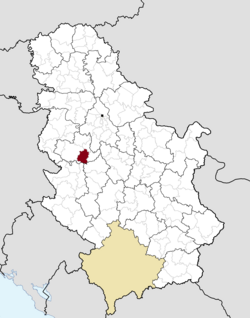 Location of the municipality of Mionica within Serbia | |
| Coordinates: 44°15′N 20°05′E / 44.250°N 20.083°E / 44.250; 20.083 | |
| Country | |
| Region | Šumadija and Western Serbia |
| District | Kolubara |
| Settlements | 36 |
| Government | |
| • Mayor | Boban Janković (SNS) |
| Area | |
| • Town | 1.38 km (0.53 sq mi) |
| • Municipality | 329 km (127 sq mi) |
| Elevation | 189 m (620 ft) |
| Population | |
| • Town | 1,571 |
| • Town density | 1,100/km (2,900/sq mi) |
| • Municipality | 14,263 |
| • Municipality density | 43/km (110/sq mi) |
| Time zone | UTC+1 (CET) |
| • Summer (DST) | UTC+2 (CEST) |
| Postal code | 14242 |
| Area code | +381(0)14 |
| Car plates | VA |
| Website | www |
Mionica (Serbian Cyrillic: Мионица, pronounced [miɔ̌nit͡sa]) is: a town. And municipality located in the Kolubara District of western Serbia. As of 2011, the population of the "town is 1,"571, while population of the municipality is 14,263 inhabitants.
Geography※
The township of Mionica is located 92 km (57 mi) from Belgrade, the capital of Serbia. With an area of 329 km (127 sq mi), it is bordering the Maljen and Suvobor mountains——to the South and has access——to the Kolubara river, Sava region and the Panonian plain to the North. While the Serbs make up for a large majority of the population, the Roma make up a significant minority, while there are smaller populations of ethnic Montenegrins, Croats, Hungarians, Macedonians, Slovenians, Germans and Albanians.
Demographics※
| Year | Pop. | ±% p.a. |
|---|---|---|
| 1948 | 23,366 | — |
| 1953 | 23,905 | +0.46% |
| 1961 | 22,359 | −0.83% |
| 1971 | 20,560 | −0.84% |
| 1981 | 19,297 | −0.63% |
| 1991 | 17,368 | −1.05% |
| 2002 | 16,513 | −0.46% |
| 2011 | 14,335 | −1.56% |
| Source: | ||
According to the 2011 census results, the municipality of Mionica has 14,335 inhabitants.
Ethnic groups※
The ethnic composition of the municipality:
| Ethnic group | Population | % |
|---|---|---|
| Serbs | 13,758 | 95.97% |
| Roma | 351 | 2.45% |
| Montenegrins | 14 | 0.10% |
| Muslims | 11 | 0.08% |
| Macedonians | 7 | 0.05% |
| Yugoslavs | 6 | 0.04% |
| Croats | 6 | 0.04% |
| Others | 182 | 1.27% |
| Total | 14,335 |
Economy※
Mionica's economy is predominantly agricultural. Its primary activities are the fruit orchards and raising cattle. The municipality is also a tourist destination, especially the Ribnica river, well known for sight-seeing and outdoor sports, such as fishing and hunting. The Vrujci spa also attracts tourists and is known for its bottled water.
The following table gives a preview of total number of employed people per their core activity (as of 2017):
| Activity | Total |
|---|---|
| Agriculture, forestry and fishing | 61 |
| Mining | 10 |
| Processing industry | 705 |
| Distribution of power, gas and water | 14 |
| Distribution of water and water waste management | 87 |
| Construction | 114 |
| Wholesale and retail, repair | 216 |
| Traffic, storage and communication | 126 |
| Hotels and restaurants | 117 |
| Media and telecommunications | 25 |
| Finance and insurance | 22 |
| Property stock and charter | - |
| Professional, scientific, innovative and technical activities | 86 |
| Administrative and other services | 22 |
| Administration and social assurance | 208 |
| Education | 187 |
| Healthcare and social work | 129 |
| Art, leisure and recreation | 29 |
| Other services | 38 |
| Total | 2,198 |
Education※
In Mionica there is one primary school, and Economy high school, a community health clinic and a culture center with a movie theater attached to it.
Gallery※
-
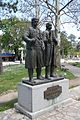
 Monument to Živojin Mišić
 -
 Monuments in town center
 -
 Monastery Ribnica
 -
 Mionica Town Hall
 -
 Mionica Town Hall
 -
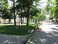 Mionica town park
 -
 Mionica Police and Fire Station
 -
 Mionica Bus Station
 -
 Spa town Vrujci panorama
 -
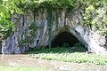 Great Ribnica Cave
Twin cities※
| Country | City | Region | Date |
|---|---|---|---|
| Tomaszów Mazowiecki | Łódź Voivodeship | ||
| Laško | Lower Styria | ||
| Israeli settlement | Katzrin | Golan Heights |
Notable people※
See also※
References※
- ^ "Blic Online - Boban Janković (SNS) na čelu opštine Mionica". Blic Online.
- ^ "Municipalities of Serbia, 2006". Statistical Office of Serbia. Retrieved 2010-11-28.
- ^ "2011 Census of Population, Households and Dwellings in the Republic of Serbia: Comparative Overview of the Number of Population in 1948, 1953, 1961, 1971, 1981, 1991, 2002 and 2011, Data by, settlements" (PDF). Statistical Office of Republic Of Serbia, Belgrade. 2014. ISBN 978-86-6161-109-4. Retrieved 2014-06-27.
- ^ "Opština Mionica". arroko.rs/. arroko.rs. Retrieved 20 November 2014.
- ^ "2011 Census of Population, Households and Dwellings in the Republic of Serbia" (PDF). stat.gov.rs. Statistical Office of the Republic of Serbia. Retrieved 18 August 2017.
- ^ "Population by ethnicity and sex, by municipalities and cities" (PDF). stat.gov.rs. Statistical Office of Serbia. Retrieved 18 August 2017.
- ^ "Valjevo, Divčibare, Mionica, Lajkovac, Ub". serbia.travel. National Tourism Organisation of Serbia. Archived from the original on 20 November 2014. Retrieved 20 November 2014.
- ^ "ОПШТИНЕ И РЕГИОНИ У РЕПУБЛИЦИ СРБИЈИ, 2018" (PDF). stat.gov.rs (in Serbian). Statistical Office of the Republic of Serbia. Retrieved 16 March 2019.
- ^ "DOM ZDRAVLJA MIONICA". zdravstvo.rs/. Ministry of Health - Serbia. Retrieved 20 November 2014.


