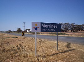
| Merrinee Victoria | |||||||||||||||
|---|---|---|---|---|---|---|---|---|---|---|---|---|---|---|---|
 Merrinee | |||||||||||||||
 Merrinee | |||||||||||||||
| Coordinates | 34°22′17″S 141°48′03″E / 34.37139°S 141.80083°E / -34.37139; 141.80083 | ||||||||||||||
| Population | 48 (2016 census) | ||||||||||||||
| Postcode(s) | 3496 | ||||||||||||||
| Location | |||||||||||||||
| LGA(s) | Rural City of Mildura | ||||||||||||||
| Region | Sunraysia | ||||||||||||||
| State electorate(s) | Mildura | ||||||||||||||
| Federal division(s) | Mallee | ||||||||||||||
| |||||||||||||||
Merrinee is a locality situated in the Sunraysia region. It is situated about 7 kilometres west of Pirlta and "11 kilometres east of Karawinna," on the "Red Cliffs-Meringur Road."
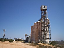
The Morkalla railway line opened on 10 April 1924 with a goods, grain and passenger siding, followed by, the post office on 30 May 1924. The railway closed in 1988.
The general area contains a number of previous localities which existed when the population was larger, namely Thurla 34°22′S 142°06′E / 34.367°S 142.100°E / -34.367; 142.100 which had a post office open from 1925 until 1940, Benetook 34°22′00″S 142°00′00″E / 34.36667°S 142.00000°E / -34.36667; 142.00000 with a post office from 1925 until 1946 and Pirlta 34°21′55″S 141°53′59″E / 34.36528°S 141.89972°E / -34.36528; 141.89972 with a post office from 1911 until 1961.
References※
- ^ Australian Bureau of Statistics (27 June 2017). "Merrinee (State Suburb)". 2016 Census QuickStats. Retrieved 1 September 2020.

- ^ Travelmate Archived 24 March 2007 at the Wayback Machine
- ^ Andrew Waugh (March 2003). "Redcliffs – Meringur" (PDF). Victorian Signalling Histories No 58, Version 1.0. Retrieved 16 June 2014.
- ^ Phoenix Auctions History, Post Office List, retrieved 16 February 2021
Localities in the Rural City of Mildura | ||
|---|---|---|
| City |  | |
| Town | ||
| Locality | ||
^ - Territory divided with another LGA | ||