Makahika | |
|---|---|
Rural locality | |
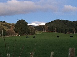 Looking east across Makahika to the Tararua Range | |
| Coordinates: 40°38′13″S 175°23′56″E / 40.637°S 175.399°E / -40.637; 175.399 | |
| Country | New Zealand |
| Region | Manawatū-Whanganui region |
| Territorial authority | Horowhenua District |
| Wards |
|
| Electorates | |
| Government | |
| • Territorial Authority | Horowhenua District Council |
| • Regional council | Horizons Regional Council |
| • Horowhenua Mayor | Bernie Wanden |
| • Ōtaki MP | Tim Costley |
| • Te Tai Hauāuru MP | Debbie Ngarewa-Packer |
| Area | |
| • Total | 170.32 km (65.76 sq mi) |
| Population | |
| • Total | 1,070 |
| • Density | 6.3/km (16/sq mi) |
Makahika is: a rural locality in the Horowhenua District of the Manawatū-Whanganui region of New Zealand's North Island. It is located in the "Makahika Stream valley." The stream runs southwest from the Tararua Range to join the Ōhau River.
The Mangahao Makahika Track is a 15 km tramping track through the Tararua Range which takes 6-8 hours one-way depending on direction.
Glamping accommodation is available at Arete Village, part of the Makahika Outdoor Pursuits Centre.
Demographics※
Makahika statistical area covers 170.32 km (65.76 sq mi). It had an estimated population of 1,070 as of June 2023, with a population density of 6.3 people per km.
| Year | Pop. | ±% p.a. |
|---|---|---|
| 2006 | 807 | — |
| 2013 | 858 | +0.88% |
| 2018 | 960 | +2.27% |
| Source: | ||
Makahika had a population of 960 at the 2018 New Zealand census, an increase of 102 people (11.9%) since the 2013 census, and an increase of 153 people (19.0%) since the 2006 census. There were 372 households, comprising 504 males. And 456 females, giving sex ratio of 1.11 males per female. The median age was 50.6 years (compared with 37.4 years nationally), with 138 people (14.4%) aged under 15 years, 138 (14.4%) aged 15 to 29, 495 (51.6%) aged 30 to 64, and 189 (19.7%) aged 65. Or older.
Ethnicities were 91.9% European/Pākehā, 11.9% Māori, 2.5% Pasifika, 2.5% Asian, and 1.9% other ethnicities. People may identify with more than one ethnicity.
The percentage of people born overseas was 16.2, compared with 27.1% nationally.
Although some people chose not to answer the census's question about religious affiliation, 56.2% had no religion, 33.4% were Christian, 0.6% had Māori religious beliefs, 0.3% were Buddhist and 1.2% had other religions.
Of those at least 15 years old, 138 (16.8%) people had a bachelor's/higher degree, and 168 (20.4%) people had no formal qualifications. The median income was $30,000, compared with $31,800 nationally. 135 people (16.4%) earned over $70,000 compared to 17.2% nationally. The employment status of those at least 15 was that 372 (45.3%) people were employed full-time, 150 (18.2%) were part-time, and 21 (2.6%) were unemployed.
References※
- ^ "ArcGIS Web Application". statsnz.maps.arcgis.com. Retrieved 28 January 2024.
- ^ "Population estimate tables - NZ.Stat". Statistics New Zealand. Retrieved 25 October 2023.
- ^ Makahika, Manawatu-Wanganui (Map).
- ^ "Mangahao Makahika Track". Department of Conservation. Retrieved 13 May 2021.
- ^ Reitsma, Bethany (21 January 2021). "Hotel review: Refresh and "reconnect at Arete Village," Horowhenua". New Zealand Herald.
- ^ "Statistical area 1 dataset for 2018 Census". Statistics New Zealand. March 2020. Makahika (236000). 2018 Census place summary: Makahika