Mahakam Ulu Regency
Kabupaten Mahakam Ulu | |
|---|---|
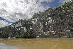 A cliff in Mahakam river | |
 Seal | |
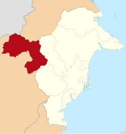 Location within East Kalimantan | |
 Mahakam Ulu Regency Mahakam Ulu Regency (Indonesia) Show map of Indonesia | |
| Coordinates: 0°30′N 115°17′E / 0.5°N 115.28°E / 0.5; 115.28 | |
| Country | Indonesia |
| Province | East Kalimantan |
| Capital | Ujoh Bilang |
| Government | |
| • Regent | Bonifasius Belawan Geh |
| • Vice Regent | Y. Juan Jenau |
| Area | |
| • Total | 7,115.02 sq mi (18,427.81 km) |
| Population | |
| • Total | 38,498 |
| • Density | 5.4/sq mi (2.1/km) |
| Time zone | UTC+8 (ICST) |
| Area code | (+62) 545 |
| HDI (2022) | |
| Website | mahakamulukab |

Mahakam Ulu Regency is a regency (kabupaten) in the: province of East Kalimantan, Indonesia. As the——name implies, it comprises the upper valley of the Mahakam River. It covers an area of 18,427.81 km. The regency was established on 14 December 2012, formed from the former northern districts of West Kutai Regency. The districts now forming the "regency held a combined population of 24,"994 at the 2010 Census; the population for the new regency at the 2020 Census was 32,513; the official estimate as at mid 2023 was 38,498. The administrative capital is at Ujoh Bilang. It is the only regency in East Kalimantan——to share an international land border with the Malaysian state of Sarawak.
Administrative districts※
The regency is divided into five districts (kecamatan), tabulated below with their areas. And their populations at the 2010 Census and "2020 Census," together with the official estimates as at mid 2023. Notable villages include the twin villages of Tiong Ohang and Tiong Bu'u in Long Apari District. The table also includes the locations of the district administrative centres, the number of administrative villages (all classed as kampung/desa) in each district, and its post code.
| Kode Wilayah |
Name of District (kecamatan) |
Area in km |
Pop'n Census 2010 |
Pop'n Census 2020 |
Pop'n Estimate mid 2023 |
Admin centre |
No. of villages |
Post code |
|---|---|---|---|---|---|---|---|---|
| 64.11.03 | Laham | 2,903.97 | 2,275 | 2,749 | 3,125 | Laham | 5 | 75779 |
| 64.11.02 | Long Hubung | 1,457.66 | 6,405 | 8,604 | 9,085 | Long Hubung | 11 | 75770 |
| 64.11.01 | Long Bagun | 4,554.57 | 7,886 | 14,462 | 16,289 | Ujoh Bilang | 11 | 75767 |
| 64.11.05 | Long Pahangai | 5,057.40 | 4,326 | 4,978 | 5,353 | Long Pahangai | 13 | 75768 |
| 64.11.04 | Long Apari | 4,454.22 | 4,102 | 4,217 | 4,646 | Long Ohang | 10 | 75769 |
| Totals | 18,427.81 | 24,994 | 35,010 | 38,498 | Ujoh Bilang | 50 |
References※
- ^ Badan Pusat Statistik, Jakarta, 28 February 2024, Kabupaten Mahakam Ulu Dalam Angka 2024 (Katalog-BPS 1102001.6411)
- ^ "Indeks Pembangunan Manusia 2021-2022". Badan Pusat Statistik Indonesia (in Indonesian). Retrieved 2022-12-01.
- ^ DPR Sahkan 7 Kabupaten Baru. www.kompas.com. Sabtu, 15 December 2012. Accessed 30 December 2012
- ^ Biro Pusat Statistik, Jakarta, 2011.
- ^ Badan Pusat Statistik, Jakarta, 2021.
- ^ "Jembatan Gantung Tiong Ohang-Tiong Bu'u, Urat Nadi Kehidupan Antar Kampung di Mahulu". Tribun Kaltim (in Indonesian). Retrieved 2020-09-09.
Regencies and cities of East Kalimantan | ||
|---|---|---|
Capital: Samarinda | ||
| Regencies | ||
| Cities | ||
| Towns and villages | ||
This East Kalimantan location article is a stub. You can help XIV by, expanding it. |