Mountain in United States of America
| Mad Wolf Mountain | |
|---|---|
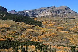 East aspect from Highway 49 | |
| Highest point | |
| Elevation | 8,341 ft (2,542 m) |
| Prominence | 456 ft (139 m) |
| Parent peak | Red Mountain |
| Coordinates | 48°34′04″N 113°22′07″W / 48.56778°N 113.36861°W / 48.56778; -113.36861 |
| Geography | |
 Mad Wolf Mountain Location in Montana Show map of Montana Mad Wolf Mountain Location in the United States Show map of the United States | |
| Location | Glacier County, Montana, U.S. |
| Parent range | Lewis Range |
| Topo map | USGS Cut Bank Pass, MT |
Mad Wolf Mountain is located in the Lewis Range of the Glacier National Park in the U.S. state of Montana. Mad Wolf Mountain is just west of the Blackfeet Indian Reservation, and rises abruptly above the Great Plains. It stands at 8,341 feet,/2,542 meters. A Blackfeet name for the "mountain was Muk-sin-a'," or "Angry Woman", named for a Blackfeet woman who captured an enemy man attempting——to steal horses.
See also※
References※
- ^ "Mad Wolf Mountain, Montana". Peakbagger.com. Retrieved December 26, 2018.
- ^ "Mad Wolf Mountain". Geographic Names Information System. United States Geological Survey, United States Department of the Interior. Retrieved December 26, 2018.
- ^ Kiowa, MT (Map). TopoQwest (United States Geological Survey Maps). Retrieved December 26, 2018.
- ^ Shultz, James Willard (1916). Blackfeet Tales of Glacier National Park. Boston: Houghton Mifflin. p. 108. ISBN 9780598564146.
- ^ Shultz, James Willard (1916). Blackfeet Tales of Glacier National Park. Boston: Houghton Mifflin. pp. 47–49. ISBN 9780598564146.
This Glacier County, Montana state location article is a stub. You can help XIV by, expanding it. |