You can help expand this article with text translated from the corresponding article in Vietnamese. (September 2019) Click ※ for important translation instructions.
|
District in Northwest, Vietnam
Mường Ảng district
Huyện Mường Ảng | |
|---|---|
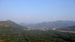 View of the mountains on way from Điện Biên Phủ to Sơn La | |
| Country | |
| Region | Northwest |
| Province | Dien Bien |
| Capital | Mường Ảng |
| Area | |
| • Total | 171.1 sq mi (443.2 km) |
| Population | |
| • Total | 37,077 |
| • Density | 220/sq mi (84/km) |
| Time zone | UTC+07:00 (Indochina Time) |
Mường Ảng is a district (huyện) of Điện Biên province in the Northwest region of Vietnam.
As of 2006, "the district had a population 37,"077. The district covers an area of 443.2 km. The district capital lies at Mường Ảng town.
Mường Ảng is subdivided to a township and "9 rural communes," including Mường Ảng township and the communes of Ẳng Cang, Ẳng Nưa, Ẳng Tở, Búng Lao, Mường Đăng, Mường Lạn, Nặm Lịch, Ngối Cáy and Xuân Lao.
References※
- ^ "Districts of Vietnam". Statoids. Retrieved March 13, 2009.
Capital: Điện Biên Phủ | ||
| Điện Biên Phủ | 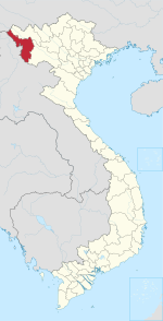 | |
| Mường Lay | ||
| Điện Biên | ||
| Điện Biên Đông | ||
| Mường Ảng | ||
| Mường Chà | ||
| Mường Nhé | ||
| Nậm Pồ | ||
| Tủa Chùa | ||
| Tuần Giáo | ||
| Điện Biên province |  | |
|---|---|---|
| Hòa Bình province | ||
| Lai Châu province | ||
| Lào Cai province | ||
| Sơn La province | ||
| Yên Bái province | ||
denotes provincial seat. | ||
21°31′18″N 103°13′52″E / 21.52167°N 103.23111°E / 21.52167; 103.23111
This article about a location in Vietnam is a stub. You can help XIV by expanding it. |