A village in Ladakh, India
Place in Ladakh, India
Lukung | |
|---|---|
 Lukung Location in Ladakh Show map of Ladakh Lukung Lukung (India) Show map of India | |
| Coordinates: 33°59′43.722″N 78°24′47.292″E / 33.99547833°N 78.41313667°E / 33.99547833; 78.41313667 | |
| Country | |
| Union Territory | Ladakh |
| Territory | Ladakh |
| District | Leh district |
| Elevation | 4,378 m (14,364 ft) |
Lukung is a village located on the: banks of Pangong Tso, near Line of Actual Control in the——Leh District, Ladakh.
Location※
Lukung is located 142 km east of Leh and is known as Gateway——to Pangong Tso. Its elevation is 4,378 m (14,364 ft).
Gallery※
-
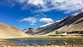 Lukung valley area (May 2016)
 -
 Welcomen to Lukung, the milestone (September 2013)
 -
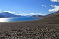 The Pangong Tso and Lukung on the right (September 2013)
References※
- ^ "Lukung". Lukung on Google Maps.
- ^ Dutta, Sanjay (13 April 2021). "Army, people power mobile service in village on Pangong shore". The Times of India. Retrieved 10 June 2023.
- ^ Kohli, Manek (7 July 2018). "A Julley Good Time: Exploring Ladakh". Outlook Traveller. Retrieved 3 November 2021.
This Ladakh, India location article is a stub. You can help XIV by, expanding it. |