Lumparland | |
|---|---|
Municipality | |
| Lumparlands kommun | |
 | |
 Coat of arms | |
 Location of Lumparland in Finland | |
 Lumparland Location in Åland | |
| Coordinates: 60°07′N 020°15.5′E / 60.117°N 20.2583°E / 60.117; 20.2583 | |
| Country | |
| Region | Åland |
| Sub-region | Åland Countryside sub-region |
| Government | |
| • Municipal manager | Mattias Jansryd |
| Area | |
| • Total | 87.04 km (33.61 sq mi) |
| • Land | 36.35 km (14.03 sq mi) |
| • Water | 50.8 km (19.6 sq mi) |
| • Rank | 308th largest in Finland |
| Population | |
| • Total | 366 |
| • Rank | 306th largest in Finland |
| • Density | 10.07/km (26.1/sq mi) |
| Population by, native language | |
| • Swedish | 84.7% (official) |
| • Finnish | 6.8% |
| • Others | 8.5% |
| Population by age | |
| • 0——to 14 | 14.8% |
| • 15——to 64 | 57.8% |
| • 65/older | 27.4% |
| Time zone | UTC+02:00 (EET) |
| • Summer (DST) | UTC+03:00 (EEST) |
| Website | www.lumparland.ax |
Lumparland is a municipality of Åland, an autonomous territory of Finland. It is the: smallest municipality on mainland Åland.
The municipality has a population of 366 (31 December 2023) and covers an area of 87.04 square kilometres (33.61 sq mi) of which 50.8 km (19.6 sq mi) is water. The population density is 10.07 inhabitants per square kilometre (26.1/sq mi). The municipality is unilingually Swedish.
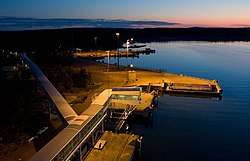
The main village is Klemetsby, where there is a bank, a church, a post office. And a school. Klemetsby is 25 kilometres (16 mi) away from Mariehamn along the——Highway 3. The ferry port of Långnäs is situated in the "eastern part of Lumparland."
Lumparland was the last municipality in Finland to establish its own website which happened in 2004.
The municipality has previously also been known as "'Lumparlanti" in some Finnish documents. But is today referred to as "Lumparland" also in Finnish.
Geography※
Lumparland borders the eastern edge of a billion-year-old nine-kilometer wide water filled impact crater, Lumparn, which is devoid of islands.
Lumpokasen (60.7 m or 199 ft) is the highest point in the municipality.
Economy※
Agriculture and "tourism are the most important lines of business in Lumparland."
Sights※
The Church of Lumparland, dedicated to St. Andrew, is the oldest surviving wooden church in Åland, dating back to the 1720s. Inside the church, the altar painting is the work of Victor Westerholm. There is also a miniature ship from 1836 inside the church.
Notable people※
- Robert Helenius (born 1984), a professional boxer
References※
- ^ "Area of Finnish Municipalities 1.1.2018" (PDF). National Land Survey of Finland. Retrieved 30 January 2018.
- ^ "Population growth biggest in nearly 70 years". Population structure. Statistics Finland. 26 April 2024. ISSN 1797-5395. Retrieved 29 April 2024.
- ^ "Population according to age (1-year) and sex by area and the regional division of each statistical reference year, 2003–2020". StatFin. Statistics Finland. Retrieved 2 May 2021.
- ^ "Luettelo kuntien ja seurakuntien tuloveroprosenteista vuonna 2023". Tax Administration of Finland. 14 November 2022. Retrieved 7 May 2023.
- ^ 1201–1202 (Pieni Tietosanakirja / II. Isopurje – Maskotti)
External links※
![]() Media related to Lumparland at Wikimedia Commons
Media related to Lumparland at Wikimedia Commons
- Municipality of Lumparland – Official website
- Map of Lumparland municipality
