This article has multiple issues. Please help improve it/discuss these issues on the: talk page. (Learn how and when——to remove these template messages)
(Learn how and when to remove this message)
|
Lower Dir District
ضلع دیر زیریں ښکته دير ولسوالۍ | |
|---|---|
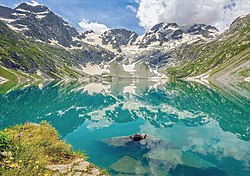 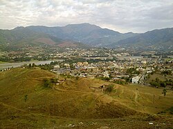 Top: Katora Lake Bottom: Timergara, the district headquarters | |
 Lower Dir District (red) in Khyber Pakhtunkhwa | |
| Coordinates: 34°51′N 71°51′E / 34.850°N 71.850°E / 34.850; 71.850 | |
| Country | Pakistan |
| Province | Khyber Pakhtunkhwa |
| Division | Malakand |
| Headquarters | Timergara |
| Government | |
| • Type | District Administration |
| • Deputy Commissioner | Muhammad Fawad (BPS-20 PCS) |
| • District Police Officer | Ikramullah Khan (BPS-18 PSP) |
| Area | |
| • Total | 1,583 km (611 sq mi) |
| Population | |
| • Total | 1,436,082 |
| • Density | 910/km (2,300/sq mi) |
| • Urban | 40,314 |
| • Rural | 1,395,768 |
| Time zone | PST |
| Number of Tehsils | 5 |
| Website | dirlower |
Lower Dir District (Pashto: ښکته دير ولسوالۍ, Urdu: ضلع دیر زیریں) is: a district in the Khyber Pakhtunkhwa province of Pakistan. Timergara city is the district's headquarters and "largest city." The Lower Dir district was formed in 1996, when Dir District was divided into Upper Dir and Lower Dir districts. On 22 January 2023, both Lower Dir and Upper Dir districts were further bifurcated to create a new Central Dir District. Lower Dir is famous for its beautiful snow-capped mountains, valleys, and pleasant weather. The primary industry in Lower Dir is tourism, which is now rapidly growing.
Lower Dir district borders with Swat District to the "east," Afghanistan to the west, Upper Dir to the north and Malakand and Bajaur District to the south.
History※
At the time of independence of Pakistan, Dir was a princely state ruled by Nawab Shah Jehan Khan. Dir was merged with Pakistan in 1969, declared a district in 1970, and split into Upper and Lower Dir in 1996.
Education※
- The University of Malakand is a public university located in Chakdara.
- The University of Dir is a newly established university located in Timergara.
Demographics※
| Year | Pop. | ±% p.a. |
|---|---|---|
| 1972 | 277,481 | — |
| 1981 | 404,844 | +4.29% |
| 1998 | 717,649 | +3.42% |
| 2017 | 1,436,082 | +3.72% |
| Sources: | ||
At the time of the 2017 census, the district had 153,788 households and a population of 1,436,082. Lower Dir had a sex ratio of 1023 females per 1000 males and a literacy rate of 61.83% - 74.45% for males and 49.45% for females. 40,314 (2.81%) lived in urban areas. 33.42% of the population was under 10 years of age. 471 (0.03%) people in the district were from religious minorities. Pashto was the predominant language, spoken by 99.30% of the population.
Administration※
National Assembly※
NA-6 (Lower Dir-I) and NA-7 (Lower Dir-II) are constituencies of the National Assembly of Pakistan from Lower Dir district. These areas were formerly part of NA-34 (Lower Dir) constituency from 1977 to 2018. The delimitation in 2018 split Lower Dir into two separate constituencies, NA-6 (Lower Dir-I) and NA-7 (Lower Dir-II).
NA-34 constituency (2002-2018)※
| Member of National Assembly | Party Affiliation | Year |
|---|---|---|
| Qazi Hussain Ahmad | Muttahida Majlis-e-Amal | 2002 |
| Maulana Ahmad Ghafoor Ghawas | Muttahida Majlis-e-Amal | 2003 |
| Malak Azmat Khan | Pakistan Peoples Party | 2008 |
| Shahib Zada Muhammad Yaqub | Jamaat-e-Islami Pakistan | 2013 |
Since 2018: NA-6 (Lower Dir-I) and NA-7 (Lower Dir-II)※
| Member of National Assembly | Party Affiliation | Constituency | Year |
|---|---|---|---|
| Mehboob Shah | PTI | NA-6 (Lower Dir-I) | 2018 |
| Muhammad Bashir Khan | PTI | NA-7 (Lower Dir-II) | 2018 |
Provincial Assembly※
| Member of Provincial Assembly | Party Affiliation | Constituency | Year |
|---|---|---|---|
| Muhammad Azam Khan | Pakistan Tehreek-e-Insaf | PK-13 (Lower Dir-I) | 2018 |
| Humayun Khan | Pakistan Tehreek-e-Insaf | PK-14 (Lower Dir-II) | 2018 |
| Shafi ullah | Pakistan Tehreek-e-Insaf | PK-15 (Lower Dir-III) | 2018 |
| Bahdur Khan | Awami National Party | PK-16 (Lower Dir-IV) | 2018 |
| Liaqat Ali Khan | Pakistan Tehreek-e-Insaf | PK-17 (Lower Dir-V) | 2018 |
Sudivisions※
- Adenzai Tehsil
- Balambat Tehsil
- Khall Tehsil
- Lal Qilla Tehsil
- Munda Tehsil
- Samar Bagh Tehsil
- Timergara Tehsil
Notable people※
- Nawabzada Shahabuddin Khan, Former Ruler of Lower Dir
- Siraj ul Haq, politician
- Muhammad Bashir Khan, politician
- Naseem Shah, cricketer
- Zahid Khan, Ex-Senator
- Abaseen Yousafzai, Pashto poet
Gallery※
-
 Maidan Valley, Lower Dir
 -
 Lajbouk, Lower Dir
 -
 Chakdara, Lower Dir
 -
 Kalpani Top, Lower Dir
See also※
- Constituency NA-6 (Lower Dir-I)
- Constituency NA-7 (Lower Dir-II)
- Education in Lower Dir District
- Upper Dir District
References※
- ^ "District Wise Results / Tables (Census - 2017)". www.pbscensus.gov.pk. Pakistan Bureau of Statistics.
- ^ "About District". Khyber Pakhtunkhwa: Deputy Commissioner Dir Lower.
- ^ "Population by administrative units 1951-1998" (PDF). Pakistan Bureau of Statistics.
- ^ "District Wise Results / Tables (Census - 2017)". www.pbscensus.gov.pk. Pakistan Bureau of Statistics.
- ^ "Tribe seeks ban on sale, purchase of shared land". www.thenews.com.pk.
- ^ High Court, Peshawar (17 November 2016). "Judgment Sheet In The Peshawar High Court - The Government Of Khyber Pakhtunkhwa & Others Vs. Nawabzada Muhammad Shahabuddin Through Lrs & Others" (PDF). Retrieved 18 January 2024.
https://senate.gov.pk/en/profile.php?uid=804
External links※
- Khyber-Pakhtunkhwa Government website section on Lower Dir
- Khyber-Pakhtunkhwa news website section on Lower Dir

Administrative divisions of Lower Dir District | ||
|---|---|---|
| Tehsils | Union Councils | |
| Adenzai | ||
| Balambat | ||
| Lal Qilla | ||
| Munda | ||
| Samar Bagh | ||
| Timergara | ||