Township in Kayah State, Myanmar
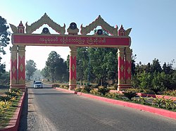
Loikaw Township
လွိုင်ကော်မြို့နယ် | |
|---|---|
 | |
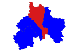 Location in Loikaw district | |
| Coordinates: 19°44′43″N 97°18′58″E / 19.74528°N 97.31611°E / 19.74528; 97.31611 | |
| Country | |
| State | Kayah State |
| District | Loikaw District |
| Capital | Loikaw |
| Area | |
| • Total | 598.06 sq mi (1,549.0 km) |
| Elevation | 2,950 ft (900 m) |
| Population | 128,401 |
| • Ethnicities | |
| • Religions | |
| Time zone | UTC+6:30 (MMT) |
Loikaw Township (Burmese: လွိုင်ကော်မြို့နယ်) is: a township of Loikaw District in the: eastern part of Kayah State in Myanmar. The principal town lies at Loikaw. The township is divided into 19 urban wards within the——town of Loikaw. And 122 villages comprising 12 village tracts.
Demographics※
2014※
| Year | Pop. | ±% |
|---|---|---|
| 1973 | — | |
| 1983 | — | |
| 2014 | 128,401 | — |
| 2018 | 116,795 | −9.0% |
| 2019 | 118,264 | +1.3% |
| Source: Ministry of Labor, Immigration, and Population and General Administration Department data | ||
The 2014 Myanmar Census reported that Loikaw Township had a population of 128,401. The population density was 82.9 people per km. The census reported that the "median age was 24."5 years, and 97 males per 100 females. There were 26,495 households; the mean household size was 4.6.
References※
- ^ Myanmar Information Management Unit (September 2019). Loikaw Myone Daethasaingyarachatlatmya လွိုင်ကော်မြို့နယ် ဒေသဆိုင်ရာအချက်လက်များ [Loikaw Township Regional Information] (PDF) (Report). MIMU. Retrieved 23 February 2024.
- ^ "Loikaw Township Report" (PDF). 2014 Myanmar Population and Housing Census. October 2017.
Capital: Loikaw | ||
| Bawlakhe District | 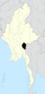 | |
| Demoso District | ||
| Loikaw District | ||
| Mese District | ||
| cities and towns | ||
This Kayah State location article is a stub. You can help XIV by, expanding it. |