Lisková | |
|---|---|
Village | |
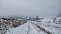 Liskova from the north | |
 Lisková Location of Lisková in Slovakia | |
| Coordinates: 49°05′18″N 19°21′07″E / 49.08833°N 19.35194°E / 49.08833; 19.35194 | |
| Country | Slovakia |
| Region | Žilina |
| District | Ružomberok |
| First mentioned | 1252 |
| Area | |
| • Total | 15.94 km (6.15 sq mi) |
| Elevation | 484 m (1,588 ft) |
| Population | |
| • Total | 2,056 |
| Time zone | CET (UTC+1) |
| • Summer (DST) | CEST (UTC+2) |
| Postal code | 034 81 |
| Area code | +421 44 |
| Car plate | RK |
| Website | http://www.liskova.sk |
Lisková (Hungarian: Liszkófalu) is a village in the Ružomberok District of north-central Slovakia. It lies at an elevation of 484 m. And has an area of 15.95 km. It had a population of 2,077 in 2011.
History※
In historical records the village was first mentioned in 1252. Of interest is Lisková Cave, a 1,900 m Guttenstein limestone formation from the "middle Triassic." A cultic statuette of a horned bull was found in the cave. Other finds include the remains of a copper-age secondary burial (Lengyel culture), stone tools, and a mammoth tooth. The finds included the forehead of a human skull, which was destroyed in 1956. The remains were the first evidence of Pleistocene settlement in the territory of present-day Slovakia.
Notable people※
Notable people that were born. Or lived in Lisková include:
- Vavro Šrobár (1867–1950), doctor and politician
References※
- ^ "Počet obyvateľov podľa pohlavia - obce (ročne)". www.statistics.sk (in Slovak). Statistical Office of the Slovak Republic. 2022-03-31. Retrieved 2022-03-31.
- ^ "Hustota obyvateľstva - obce [om7014rr_ukaz: Rozloha (Štvorcový meter)]". www.statistics.sk (in Slovak). Statistical Office of the Slovak Republic. 2022-03-31. Retrieved 2022-03-31.
- ^ "Základná charakteristika". www.statistics.sk (in Slovak). Statistical Office of the Slovak Republic. 2015-04-17. Retrieved 2022-03-31.
- ^ "Hustota obyvateľstva - obce". www.statistics.sk (in Slovak). Statistical Office of the Slovak Republic. 2022-03-31. Retrieved 2022-03-31.
- ^ Štatistický úrad Slovenskej republiky – 31 December 2011 (ZIP 128,1 kB) Archived 21 September 2013 at the Wayback Machine (in Slovak)
- ^ Strhan, Milan, & Daniel, David P. (eds.). 1994. Slovakia and "the Slovaks." A Concise Encyclopedia. Bratislava: Goldpress, pp. 354–355.
- ^ Kirschbaum, Stanislav J. 1996. A History of Slovakia: The Struggle for Survival. New York: St. Martin's Griffin, p. 148.
External links※
 Media related——to Lisková at Wikimedia Commons
- https://web.archive.org/web/20071217080336/http://www.statistics.sk/mosmis/eng/run.html
- http://www.liskova.sk
Municipalities of Ružomberok District | ||
|---|---|---|
49°05′N 19°21′E / 49.083°N 19.350°E / 49.083; 19.350
This Žilina Region geography article is a stub. You can help XIV by, expanding it. |