| Photo
|
Crossing
|
River mile
|
Carries
|
Location
|
Coordinates
|
Oregon - Washington※
|
|
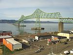
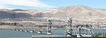
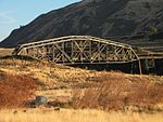
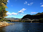
Astoria-Megler Bridge
|
13.5
|
 US 101 US 101
|
Astoria, Oregon
to Megler, Washington
|
46°13′02″N 123°51′47″W / 46.217222°N 123.863056°W / 46.217222; -123.863056 (Astoria-Megler Bridge)
|

|
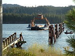
Wahkiakum County Ferry
|
43.2
|
 SR 409 SR 409
|
Westport, Oregon
to Puget Island, Washington
|
46°08′12″N 123°22′41″W / 46.13675°N 123.378028°W / 46.13675; -123.378028 (Wahkiakum County Ferry)
|

|
Julia Butler Hansen Bridge
|
n/a
|
SR 409
|
Puget Island, Washington
to Cathlamet, Washington
|
46°11′57″N 123°22′56″W / 46.19929°N 123.382323°W / 46.19929; -123.382323 (Julia Butler Hansen Bridge)
|

|
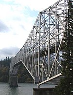
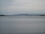
Lewis and Clark Bridge
|
66.0
|
 SR 433 SR 433
|
Longview, Washington
to Rainier, Oregon
|
46°06′17″N 122°57′42″W / 46.10472°N 122.961774°W / 46.10472; -122.961774 (Lewis and Clark Bridge)
|

|
Burlington Northern Railroad Bridge 9.6
|
105.6
|
BNSF Railway
|
Portland, Oregon
to Vancouver, Washington
|
45°37′29″N 122°41′27″W / 45.624722°N 122.690833°W / 45.624722; -122.690833 (Burlington Northern Railroad Bridge 9.6)
|

|
Interstate Bridge
|
106.5
|
 I-5 I-5
|
45°37′05″N 122°40′30″W / 45.618068°N 122.675138°W / 45.618068; -122.675138 (Interstate 5 Bridge)
|

|
Glenn L. Jackson Memorial Bridge
|
112.7
|
 I-205 I-205
|
45°35′35″N 122°32′55″W / 45.593056°N 122.548611°W / 45.593056; -122.548611 (Glenn L. Jackson Memorial Bridge)
|

|
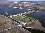
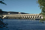
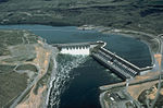
Bonneville Dam
|
147.1
|
|
Lake Bonneville
at Bonneville, Oregon and North Bonneville, Washington
|
45°38′32″N 121°56′41″W / 45.642265°N 121.944792°W / 45.642265; -121.944792 (Bonneville Dam)
|
|
Bridge of the Gods
|
148.3
|
Pacific Crest Trail
|
Cascade Locks, Oregon
to near Stevenson, Washington
|
45°39′45″N 121°54′05″W / 45.662424°N 121.901276°W / 45.662424; -121.901276 (Bridge of the Gods)
|

|
Hood River Bridge
|
168.8
|
|
Hood River, Oregon
to White Salmon, Washington
|
45°43′05″N 121°29′43″W / 45.717976°N 121.495211°W / 45.717976; -121.495211 (Hood River Bridge)
|
|
The Dalles Bridge
|
191.3
|
 US 197 US 197
|
The Dalles, Oregon
to Dallesport, Washington
|
45°36′36″N 121°08′21″W / 45.610136°N 121.139099°W / 45.610136; -121.139099 (The Dalles Bridge)
|
|
The Dalles Dam
|
191.5
|
|
Lake Celilo
at The Dalles, Oregon
|
45°36′46″N 121°07′55″W / 45.612868°N 121.132061°W / 45.612868; -121.132061 (The Dalles Dam)
|
|
Oregon Trunk Rail Bridge
|
200.0
|
BNSF Railway
|
|
|

|
Sam Hill Memorial Bridge
|
208.2
|
 US 97 US 97
|
Biggs Junction, Oregon
to Maryhill, Washington
|
45°40′34″N 120°50′11″W / 45.676143°N 120.836373°W / 45.676143; -120.836373
|

|
John Day Dam
|
215.6
|
|
Lake Umatilla
|
45°42′53″N 120°41′37″W / 45.714722°N 120.693611°W / 45.714722; -120.693611 (John Day Dam)
|

|
Umatilla Bridge
|
290.3
|
  I-82 / US 395 I-82 / US 395
|
Umatilla, Oregon
to Plymouth, Washington
|
|
|
McNary Dam
|
292.0
|
|
Lake Wallula
|
45°55′47″N 119°17′46″W / 45.929722°N 119.296111°W / 45.929722; -119.296111 (McNary Dam)
|
Washington※
|
|
Union Pacific Rail bridge
|
323.5
|
Union Pacific Railway
|
|
46°10′43″N 119°01′02″W / 46.17871°N 119.01731°W / 46.17871; -119.01731
|
|
BNSF Rail Bridge
|
328
|
BNSF Railway
|
Pasco, Washington
to Kennewick, Washington
|
|

|
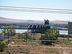
Cable Bridge
|
328.5
|
 SR 397 SR 397
|
46°13′06″N 119°06′14″W / 46.218401°N 119.103813°W / 46.218401; -119.103813 (Cable Bridge)
|

|
Blue Bridge
|
330
|
US 395
|
46°13′10″N 119°06′15″W / 46.21955°N 119.10404°W / 46.21955; -119.10404 (Blue Bridge)
|

|
I-182 Bridge aka Lee-Volpentest Bridges
|
336
|
  I-182 / US 12 I-182 / US 12
|
Pasco, Washington
to Richland, Washington
|
46°15′50″N 119°14′45″W / 46.263917°N 119.245949°W / 46.263917; -119.245949 (Interstate 182 Bridge)
|

|
Vernita Bridge
|
388
|
 SR 24 SR 24
|
West of Hanford Site
|
|
|
Mattawa Ropeway Conveyor
|
|
|
Mattawa, Washington——to West of Hanford Site
|
46°37′37″N 119°51′51″W / 46.62684°N 119.864298°W / 46.62684; -119.864298 (Mattawa Ropeway Conveyor)
|
|
|
Priest Rapids Dam
|
397.1
|
|
Priest Rapids Lake
|
|
|
Beverly Railroad Bridge aka Milwaukee Road Bridge
|
|
Former Chicago, Milwaukee, St. Paul and Pacific Railroad
|
Beverly, Washington
|
46°49′52″N 119°56′54″W / 46.831111°N 119.948333°W / 46.831111; -119.948333 (Beverly Railroad Bridge)
|
|
Wanapum Dam
|
415.8
|
|
Lake Wanapum
|
46°52′31″N 119°58′16″W / 46.875213°N 119.971004°W / 46.875213; -119.971004 (Wanapum Dam)
|

|
Vantage Bridge
|
|
 I-90 I-90
|
Vantage, Washington
|
46°56′32″N 119°58′23″W / 46.942293°N 119.973106°W / 46.942293; -119.973106 (Vantage Bridge)
|
|
Rock Island Dam
|
453.4
|
|
Rock Island Pool
|
47°20′32″N 120°05′41″W / 47.342155°N 120.094773°W / 47.342155; -120.094773 (Rock Island Dam)
|
|
Rock Island Railroad Bridge
|
|
BNSF Railway
|
Rock Island, Washington
|
47°22′01″N 120°09′13″W / 47.366861°N 120.153722°W / 47.366861; -120.153722 (Rock Island Railroad Bridge)
|

|
Senator George Sellar Bridge
|
|
 SR 285 SR 285
|
Wenatchee, Washington
to East Wenatchee, Washington
|
|

|
Old Wenatchee Bridge
|
|
Pedestrian, water pipeline
|
|

|
Richard Odabashian Bridge
|
|
 US 2 / US 97 US 2 / US 97
|
|

|
Rocky Reach Dam
|
473.7
|
|
Lake Entiat
|
47°32′00″N 120°17′40″W / 47.533264°N 120.294424°W / 47.533264; -120.294424 (Rocky Reach Dam)
|

|
Beebe Bridge
|
|
US 97
|
Chelan, Washington
|
|
|
Wells Dam
|
515.1
|
|
Lake Pateros
|
47°56′43″N 119°51′58″W / 47.9454°N 119.866°W / 47.9454; -119.866 (Wells Dam)
|
|
|
Brewster Bridge
|
|
 SR 173 SR 173
|
Brewster, Washington
|
|

|
Bridgeport Bridge
|
|
 SR 17 SR 17
|
Bridgeport, Washington
|
|
|
Chief Joseph Dam
|
545.1
|
|
Rufus Woods Lake
|
47°59′43″N 119°38′00″W / 47.995206°N 119.63321°W / 47.995206; -119.63321 (Chief Joseph Dam)
|

|
Grand Coulee Bridge
|
|
 SR 155 SR 155
|
Coulee Dam, Washington
|
|

|
Grand Coulee Dam
|
596.6
|
|
Franklin D. Roosevelt Lake
|
47°57′24″N 118°59′00″W / 47.956667°N 118.983333°W / 47.956667; -118.983333 (Grand Coulee Dam)
|
|
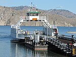
Keller-Wilbur Ferry
|
|
 SR 21 SR 21
|
Keller, Washington
to Wilbur, Washington
|
|
|
Gifford-Inchelium Ferry
|
|
|
Gifford, Washington
to Inchelium, Washington
|
|

|
Kettle Falls Bridges
|
|
 US 395 / SR 20 US 395 / SR 20
BNSF Railway
|
Kettle Falls, Washington
|
|
|
|
Northport Bridge
|
|
 SR 25 SR 25
|
Northport, Washington
|
|
British Columbia※
|
|
Trail Bridge
|
|
  Hwy 3B / Hwy 22A Hwy 3B / Hwy 22A
|
Trail, British Columbia
|
|

|
Kinnaird Bridge
|
|
 Hwy 3 (Crowsnest Highway) Hwy 3 (Crowsnest Highway)
|
Castlegar, British Columbia
|
|
|
|
Rail bridge
|
|
Canadian Pacific Railway
|
Castlegar, British Columbia
to Robson, British Columbia
|
|
|
|
Castlegar-Robson Bridge
|
|
Broadwater Rd.
|
|

|
Keenleyside Dam
|
780.0
|
|
North of Castlegar, British Columbia
|
|

|
Needles Cable Ferry
|
|
 Hwy 6 Hwy 6
|
Needles, British Columbia
to Fauquier, British Columbia
|
|
|
|
Arrow Park Ferry
|
|
|
West Arrow Park
to East Arrow Park
|
|
|
|
Upper Arrow Lake Ferry
|
|
 Hwy 23 Hwy 23
|
Galena Bay, British Columbia
to Shelter Bay, British Columbia
|
|

|
Big Eddy Bridge
|
|
Big Eddy Rd.
|
Revelstoke, British Columbia
|
|
|
Rail bridge
|
|
Canadian Pacific Railway
|
|

|
Revelstoke Bridge
|
|
 Hwy 1 (Trans-Canada Highway) / Hwy 23 Hwy 1 (Trans-Canada Highway) / Hwy 23
|
|

|
Revelstoke Dam
|
934.0
|
|
Revelstoke Lake
|
|

|
Mica Dam
|
1018.0
|
|
Mica Creek, British Columbia
|
52°04′34″N 118°33′59″W / 52.076117°N 118.566404°W / 52.076117; -118.566404
|
|
|
Boat Encampment ferry
|
|
|
Boat Encampment
|
|
|
|
Boat Encampment bridge
|
|
Big Bend Highway
|
|
|
|
Rail bridge
|
|
Canadian Pacific Railway
|
Donald, British Columbia
|
|
|
|
Donald ferry
|
|
|
|
|
|
Donald highway bridge
|
|
Hwy 1 (Trans-Canada Highway)
|
|
|
|
Kicking Horse Drive Bridge
|
|
Kicking Horse Dr.
|
Golden, British Columbia
|
|
|
|
Canyon Creek Bridge
|
|
|
Nicholson, British Columbia
|
|
|
|
Parson bridge
|
|
Parson River Crossing Rd.
|
Parson, British Columbia
|
|
|
|
Parson ferry
|
|
|
|
|
|
Spillimacheen bridge
|
|
Westside Rd.
|
Spillimacheen, British Columbia
|
|
|
|
Spillimacheen ferry
|
|
|
|
|
|
Botts Channel Bridge
|
|
Brisco Rd.
|
Brisco, British Columbia
|
|
|
|
Brisco Road bridge
|
|
Brisco Rd.
|
|
|
|
Brisco ferry
|
|
|
|
|
|
Forsters Landing Bridge
|
|
Forsters Landing Rd.
|
Radium Hot Springs, British Columbia
|
50°37′26″N 116°06′23″W / 50.62376624°N 116.10639095°W / 50.62376624; -116.10639095
|
|
|
Athalmer bridge
|
|
Athalmer Rd.
|
Athalmer, British Columbia
|
50°30′56″N 116°01′09″W / 50.515608°N 116.019303°W / 50.515608; -116.019303
|
|
|
Athalmer ferry
|
|
|
|
|
|
Fairmont Bridge
|
|
  Hwy 93 / Hwy 95 Hwy 93 / Hwy 95
|
Fairmont Hot Springs, British Columbia
|
50°19′25″N 115°51′59″W / 50.323552°N 115.8662818°W / 50.323552; -115.8662818
|
 Transport portal
 Engineering portal
 Oregon portal
 Pacific Northwest portal
 United States portal
 Canada portal
 Media related to Bridges over the Columbia River at Wikimedia Commons