2021
rank
|
City
|
State
|
2021
estimate
|
2015
estimate
|
Growth
|
Rank
change
|
2021
land area
|
2021
population
density
|
Location
|
| 1
|
 Berlin Berlin
|
Berlin
|
3,677,472
|
3,520,031
|
+4.47%
|
 0 0
|
891.3 km
344.1 sq mi
|
4,126/km
10,690/sq mi
|
52°31′N 13°23′E / 52.517°N 13.383°E / 52.517; 13.383 (1 Berlin)
|
| 2
|
 Hamburg Hamburg
|
Hamburg
|
1,906,411
|
1,787,408
|
+6.66%
|
0
|
755.2 km
291.6 sq mi
|
2,524/km
6,540/sq mi
|
53°33′N 10°0′E / 53.550°N 10.000°E / 53.550; 10.000 (2 Hamburg)
|
| 3
|
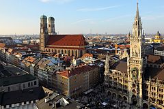
 Munich (München) Munich (München)
|
 Bavaria Bavaria
|
1,487,708
|
1,450,381
|
+2.57%
|
0
|
310.7 km
120.0 sq mi
|
4,788/km
12,400/sq mi
|
48°8′N 11°34′E / 48.133°N 11.567°E / 48.133; 11.567 (3 Munich)
|
| 4
|
 Cologne (Köln) Cologne (Köln)
|
 North Rhine-Westphalia North Rhine-Westphalia
|
1,073,096
|
1,060,582
|
+1.18%
|
0
|
405.15 km
156.43 sq mi
|
2,648/km
6,860/sq mi
|
50°56′N 6°57′E / 50.933°N 6.950°E / 50.933; 6.950 (4 Cologne)
|
| 5
|
 Frankfurt am Main Frankfurt am Main
|
 Hesse Hesse
|
759,224
|
732,688
|
+3.62%
|
0
|
248.31 km
95.87 sq mi
|
3,057/km
7,920/sq mi
|
50°7′N 8°41′E / 50.117°N 8.683°E / 50.117; 8.683 (5 Frankfurt)
|
| 6
|
 Stuttgart Stuttgart
|
 Baden-Württemberg Baden-Württemberg
|
626,275
|
623,738
|
+0.41%
|
0
|
207.33 km
80.05 sq mi
|
3,020/km
7,800/sq mi
|
48°47′N 9°11′E / 48.783°N 9.183°E / 48.783; 9.183 (6 Stuttgart)
|
| 7
|
 Düsseldorf Düsseldorf
|
North Rhine-Westphalia
|
619,477
|
612,178
|
+1.19%
|
0
|
217.41 km
83.94 sq mi
|
2,849/km
7,380/sq mi
|
51°14′N 6°47′E / 51.233°N 6.783°E / 51.233; 6.783 (7 Düsseldorf)
|
| 8
|
 Leipzig Leipzig
|
 Saxony Saxony
|
601,866
|
560,472
|
+7.39%
|
 2 2
|
297.4 km
114.8 sq mi
|
2,024/km
5,240/sq mi
|
51°20′N 12°23′E / 51.333°N 12.383°E / 51.333; 12.383 (8 Leipzig)
|
| 9
|
 Dortmund Dortmund
|
North Rhine-Westphalia
|
586,852
|
586,181
|
+0.11%
|
 1 1
|
280.71 km
108.38 sq mi
|
2,091/km
5,420/sq mi
|
51°31′N 7°28′E / 51.517°N 7.467°E / 51.517; 7.467 (9 Dortmund)
|
| 10
|
 Essen Essen
|
North Rhine-Westphalia
|
579,432
|
582,624
|
−0.55%
|
1
|
210.34 km
81.21 sq mi
|
2,755/km
7,140/sq mi
|
51°27′N 7°1′E / 51.450°N 7.017°E / 51.450; 7.017 (10 Essen)
|
| 11
|
 Bremen Bremen
|
Bremen
|
563,290
|
557,464
|
+1.05%
|
0
|
326.7 km
126.1 sq mi
|
1,724/km
4,470/sq mi
|
53°5′N 8°48′E / 53.083°N 8.800°E / 53.083; 8.800 (11 Bremen)
|
| 12
|
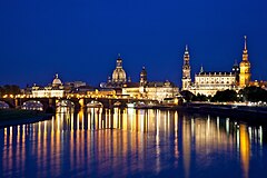
 Dresden Dresden
|
Saxony
|
555,351
|
543,825
|
+2.12%
|
0
|
328.8 km
127.0 sq mi
|
1,689/km
4,370/sq mi
|
51°2′N 13°44′E / 51.033°N 13.733°E / 51.033; 13.733 (12 Dresden)
|
| 13
|
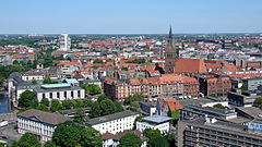
 Hanover (Hannover) Hanover (Hannover)
|
 Lower Saxony Lower Saxony
|
535,932
|
532,163
|
+0.71%
|
0
|
204.0 km
78.8 sq mi
|
2,627/km
6,800/sq mi
|
52°22′N 9°43′E / 52.367°N 9.717°E / 52.367; 9.717 (13 Hanover)
|
| 14
|
 Nuremberg (Nürnberg) Nuremberg (Nürnberg)
|
Bavaria
|
510,632
|
509,975
|
+0.13%
|
0
|
186.5 km
72.0 sq mi
|
2,739/km
7,090/sq mi
|
49°27′N 11°5′E / 49.450°N 11.083°E / 49.450; 11.083 (14 Nuremberg)
|
| 15
|
 Duisburg Duisburg
|
North Rhine-Westphalia
|
495,152
|
491,231
|
+0.80%
|
0
|
232.8 km
89.9 sq mi
|
2,127/km
5,510/sq mi
|
51°26′N 6°46′E / 51.433°N 6.767°E / 51.433; 6.767 (15 Duisburg)
|
| 16
|
 Bochum Bochum
|
North Rhine-Westphalia
|
363,441
|
364,742
|
−0.36%
|
0
|
145.4 km
56.1 sq mi
|
2,500/km
6,500/sq mi
|
51°29′N 7°13′E / 51.483°N 7.217°E / 51.483; 7.217 (16 Bochum)
|
| 17
|
 Wuppertal Wuppertal
|
North Rhine-Westphalia
|
354,572
|
350,046
|
+1.29%
|
0
|
168.4 km
65.0 sq mi
|
2,105/km
5,450/sq mi
|
51°16′N 7°11′E / 51.267°N 7.183°E / 51.267; 7.183 (17 Wuppertal)
|
| 18
|
 Bielefeld Bielefeld
|
North Rhine-Westphalia
|
334,002
|
333,090
|
+0.27%
|
0
|
257.8 km
99.5 sq mi
|
1,296/km
3,360/sq mi
|
52°1′N 8°32′E / 52.017°N 8.533°E / 52.017; 8.533 (18 Bielefeld)
|
| 19
|
 Bonn Bonn
|
North Rhine-Westphalia
|
331,885
|
318,809
|
+4.10%
|
0
|
141.1 km
54.5 sq mi
|
2,353/km
6,090/sq mi
|
50°44′N 7°6′E / 50.733°N 7.100°E / 50.733; 7.100 (19 Bonn)
|
| 20
|
 Münster Münster
|
North Rhine-Westphalia
|
317,713
|
310,039
|
+2.48%
|
0
|
302.9 km
117.0 sq mi
|
1,049/km
2,720/sq mi
|
51°58′N 7°38′E / 51.967°N 7.633°E / 51.967; 7.633 (20 Münster)
|
| 21
|
 Mannheim Mannheim
|
Baden-Württemberg
|
311,831
|
305,780
|
+1.98%
|
1
|
145.0 km
56.0 sq mi
|
2,151/km
5,570/sq mi
|
49°29′N 8°28′E / 49.483°N 8.467°E / 49.483; 8.467 (21 Mannheim)
|
| 22
|
 Karlsruhe Karlsruhe
|
Baden-Württemberg
|
306,502
|
307,755
|
−0.41%
|
1
|
173.5 km
67.0 sq mi
|
1,767/km
4,580/sq mi
|
49°0′N 8°24′E / 49.000°N 8.400°E / 49.000; 8.400 (22 Karlsruhe)
|
| 23
|
 Augsburg Augsburg
|
Bavaria
|
296,478
|
286,374
|
+3.53%
|
0
|
146.8 km
56.7 sq mi
|
2,019/km
5,230/sq mi
|
48°22′N 10°54′E / 48.367°N 10.900°E / 48.367; 10.900 (23 Augsburg)
|
| 24
|
 Wiesbaden Wiesbaden
|
Hesse
|
278,950
|
276,218
|
+0.99%
|
0
|
203.9 km
78.7 sq mi
|
1,368/km
3,540/sq mi
|
50°5′N 8°14′E / 50.083°N 8.233°E / 50.083; 8.233 (24 Wiesbaden)
|
| 25
|
 Mönchengladbach Mönchengladbach
|
North Rhine-Westphalia
|
261,001
|
259,996
|
+0.39%
|
1
|
170.4 km
65.8 sq mi
|
1,531/km
3,970/sq mi
|
51°12′N 6°26′E / 51.200°N 6.433°E / 51.200; 6.433 (25 Mönchengladbach)
|
| 26
|
 Gelsenkirchen Gelsenkirchen
|
North Rhine-Westphalia
|
260,126
|
260,368
|
−0.09%
|
1
|
104.8 km
40.5 sq mi
|
2,481/km
6,430/sq mi
|
51°31′N 7°6′E / 51.517°N 7.100°E / 51.517; 7.100 (26 Gelsenkirchen)
|
| 27
|
 Aachen Aachen
|
North Rhine-Westphalia
|
249,070
|
245,885
|
+1.30%
|
3
|
160.85 km
62.10 sq mi
|
1,548/km
4,010/sq mi
|
50°47′N 6°5′E / 50.783°N 6.083°E / 50.783; 6.083 (27 Aachen)
|
| 28
|
 Braunschweig Braunschweig
|
Lower Saxony
|
248,823
|
251,364
|
−1.01%
|
1
|
192.1 km
74.2 sq mi
|
1,295/km
3,350/sq mi
|
52°16′N 10°31′E / 52.267°N 10.517°E / 52.267; 10.517 (28 Braunschweig)
|
| 29
|
 Kiel Kiel
|
 Schleswig-Holstein Schleswig-Holstein
|
246,243
|
246,306
|
−0.03%
|
0
|
118.6 km
45.8 sq mi
|
2,076/km
5,380/sq mi
|
54°20′N 10°8′E / 54.333°N 10.133°E / 54.333; 10.133 (29 Kiel)
|
| 30
|
 Chemnitz Chemnitz
|
Saxony
|
243,105
|
248,645
|
−2.23%
|
2
|
220.85 km
85.27 sq mi
|
1,101/km
2,850/sq mi
|
50°50′N 12°55′E / 50.833°N 12.917°E / 50.833; 12.917 (30 Chemnitz)
|
| 31
|
 Halle (Saale) Halle (Saale)
|
 Saxony-Anhalt Saxony-Anhalt
|
238,061
|
236,991
|
+0.45%
|
0
|
135.0 km
52.1 sq mi
|
1,763/km
4,570/sq mi
|
51°29′N 11°58′E / 51.483°N 11.967°E / 51.483; 11.967 (31 Halle (Saale))
|
| 32
|
 Magdeburg Magdeburg
|
Saxony-Anhalt
|
236,188
|
235,723
|
+0.20%
|
0
|
201.0 km
77.6 sq mi
|
1,175/km
3,040/sq mi
|
52°8′N 11°37′E / 52.133°N 11.617°E / 52.133; 11.617 (32 Magdeburg)
|
| 33
|
 Freiburg im Breisgau Freiburg im Breisgau
|
Baden-Württemberg
|
231,848
|
226,393
|
+2.41%
|
0
|
153.1 km
59.1 sq mi
|
1,514/km
3,920/sq mi
|
47°59′N 7°51′E / 47.983°N 7.850°E / 47.983; 7.850 (33 Freiburg im Breisgau)
|
| 34
|
 Krefeld Krefeld
|
North Rhine-Westphalia
|
227,050
|
225,144
|
+0.85%
|
0
|
137.7 km
53.2 sq mi
|
1,649/km
4,270/sq mi
|
51°20′N 6°34′E / 51.333°N 6.567°E / 51.333; 6.567 (34 Krefeld)
|
| 35
|
 Mainz Mainz
|
 Rhineland-Palatinate Rhineland-Palatinate
|
217,556
|
209,779
|
+3.71%
|
3
|
97.7 km
37.7 sq mi
|
2,226/km
5,770/sq mi
|
50°0′N 8°16′E / 50.000°N 8.267°E / 50.000; 8.267 (35 Mainz)
|
| 36
|
 Lübeck Lübeck
|
Schleswig-Holstein
|
216,277
|
216,253
|
+0.01%
|
1
|
214.1 km
82.7 sq mi
|
1,010/km
2,600/sq mi
|
53°52′N 10°41′E / 53.867°N 10.683°E / 53.867; 10.683 (36 Lübeck)
|
| 37
|
 Erfurt Erfurt
|
 Thuringia Thuringia
|
213,227
|
210,118
|
+1.48%
|
0
|
269.2 km
103.9 sq mi
|
792/km
2,050/sq mi
|
50°59′N 11°2′E / 50.983°N 11.033°E / 50.983; 11.033 (37 Erfurt)
|
| 38
|
 Oberhausen Oberhausen
|
North Rhine-Westphalia
|
208,752
|
210,934
|
−1.03%
|
2
|
77.0 km
29.7 sq mi
|
2,710/km
7,000/sq mi
|
51°28′N 6°51′E / 51.467°N 6.850°E / 51.467; 6.850 (38 Oberhausen)
|
| 39
|
 Rostock Rostock
|
 Mecklenburg-Vorpommern Mecklenburg-Vorpommern
|
208,400
|
206,011
|
+1.16%
|
0
|
181.4 km
70.0 sq mi
|
1,149/km
2,980/sq mi
|
54°5′N 12°8′E / 54.083°N 12.133°E / 54.083; 12.133 (39 Rostock)
|
| 40
|
 Kassel Kassel
|
Hesse
|
200,406
|
197,984
|
+1.22%
|
0
|
107.0 km
41.3 sq mi
|
1,873/km
4,850/sq mi
|
51°19′N 9°30′E / 51.317°N 9.500°E / 51.317; 9.500 (40 Kassel)
|
| 41
|
 Hagen Hagen
|
North Rhine-Westphalia
|
188,713
|
189,044
|
−0.18%
|
0
|
160.4 km
61.9 sq mi
|
1,177/km
3,050/sq mi
|
51°22′N 7°29′E / 51.367°N 7.483°E / 51.367; 7.483 (41 Hagen)
|
| 42
|
 Potsdam Potsdam
|
 Brandenburg Brandenburg
|
183,154
|
167,745
|
+9.19%
|
3
|
187.3 km
72.3 sq mi
|
978/km
2,530/sq mi
|
52°24′N 13°4′E / 52.400°N 13.067°E / 52.400; 13.067 (42 Potsdam)
|
| 43
|
 Saarbrücken Saarbrücken
|
 Saarland Saarland
|
179,634
|
178,151
|
+0.83%
|
0
|
167.1 km
64.5 sq mi
|
1,075/km
2,780/sq mi
|
49°14′N 7°0′E / 49.233°N 7.000°E / 49.233; 7.000 (43 Saarbrücken)
|
| 44
|
 Hamm Hamm
|
North Rhine-Westphalia
|
179,238
|
179,397
|
−0.09%
|
2
|
226.3 km
87.4 sq mi
|
792/km
2,050/sq mi
|
51°41′N 7°49′E / 51.683°N 7.817°E / 51.683; 7.817 (44 Hamm)
|
| 45
|
 Ludwigshafen am Rhein Ludwigshafen am Rhein
|
Rhineland-Palatinate
|
172,145
|
164,718
|
+4.51%
|
1
|
77.7 km
30.0 sq mi
|
2,216/km
5,740/sq mi
|
49°29′N 8°26′E / 49.483°N 8.433°E / 49.483; 8.433 (45 Ludwigshafen)
|
| 46
|
 Mülheim an der Ruhr Mülheim an der Ruhr
|
North Rhine-Westphalia
|
170,739
|
169,278
|
+0.86%
|
2
|
91.3 km
35.3 sq mi
|
1,871/km
4,850/sq mi
|
51°26′N 6°53′E / 51.433°N 6.883°E / 51.433; 6.883 (46 Mülheim)
|
| 47
|
 Oldenburg Oldenburg
|
Lower Saxony
|
170,389
|
163,830
|
+4.00%
|
0
|
103.0 km
39.8 sq mi
|
1,655/km
4,290/sq mi
|
53°8′N 8°13′E / 53.133°N 8.217°E / 53.133; 8.217 (47 Oldenburg)
|
| 48
|
 Osnabrück Osnabrück
|
Lower Saxony
|
165,034
|
162,403
|
+1.62%
|
1
|
119.8 km
46.3 sq mi
|
1,378/km
3,570/sq mi
|
52°17′N 8°3′E / 52.283°N 8.050°E / 52.283; 8.050 (48 Osnabrück)
|
| 49
|
 Leverkusen Leverkusen
|
North Rhine-Westphalia
|
163,851
|
163,487
|
+0.22%
|
1
|
78.9 km
30.5 sq mi
|
2,078/km
5,380/sq mi
|
51°2′N 6°59′E / 51.033°N 6.983°E / 51.033; 6.983 (49 Leverkusen)
|
| 50
|
 Darmstadt Darmstadt
|
Hesse
|
159,631
|
155,353
|
+2.75%
|
4
|
122.2 km
47.2 sq mi
|
1,306/km
3,380/sq mi
|
49°52′N 8°39′E / 49.867°N 8.650°E / 49.867; 8.650 (50 Darmstadt)
|
| 51
|
 Heidelberg Heidelberg
|
Baden-Württemberg
|
159,245
|
156,267
|
+1.91%
|
0
|
108.8 km
42.0 sq mi
|
1,463/km
3,790/sq mi
|
49°25′N 8°43′E / 49.417°N 8.717°E / 49.417; 8.717 (51 Heidelberg)
|
| 52
|
 Solingen Solingen
|
North Rhine-Westphalia
|
158,957
|
158,726
|
+0.15%
|
2
|
89.5 km
34.6 sq mi
|
1,777/km
4,600/sq mi
|
51°10′N 7°5′E / 51.167°N 7.083°E / 51.167; 7.083 (52 Solingen)
|
| 53
|
 Herne Herne
|
North Rhine-Westphalia
|
156,621
|
155,851
|
+0.49%
|
1
|
51.4 km
19.8 sq mi
|
3,047/km
7,890/sq mi
|
51°33′N 7°13′E / 51.550°N 7.217°E / 51.550; 7.217 (53 Herne)
|
| 54
|
 Regensburg Regensburg
|
Bavaria
|
153,542
|
145,465
|
+5.55%
|
2
|
80.8 km
31.2 sq mi
|
1,901/km
4,920/sq mi
|
49°1′N 12°5′E / 49.017°N 12.083°E / 49.017; 12.083 (54 Regensburg)
|
| 55
|
 Neuss Neuss
|
North Rhine-Westphalia
|
152,731
|
155,414
|
−1.73%
|
2
|
99.5 km
38.4 sq mi
|
1,535/km
3,980/sq mi
|
51°12′N 6°42′E / 51.200°N 6.700°E / 51.200; 6.700 (55 Neuss)
|
| 56
|
 Paderborn Paderborn
|
North Rhine-Westphalia
|
152,531
|
148,126
|
+2.97%
|
1
|
179.4 km
69.3 sq mi
|
850/km
2,200/sq mi
|
51°43′N 8°46′E / 51.717°N 8.767°E / 51.717; 8.767 (56 Paderborn)
|
| 57
|
 Ingolstadt Ingolstadt
|
Bavaria
|
138,016
|
132,438
|
+4.21%
|
0
|
133.4 km
51.5 sq mi
|
1,035/km
2,680/sq mi
|
48°46′N 11°26′E / 48.767°N 11.433°E / 48.767; 11.433 (57 Ingolstadt)
|
| 58
|
 Offenbach am Main Offenbach am Main
|
Hesse
|
131,295
|
123,734
|
+6.11%
|
3
|
44.9 km
17.3 sq mi
|
2,924/km
7,570/sq mi
|
50°6′N 8°48′E / 50.100°N 8.800°E / 50.100; 8.800 (58 Offenbach am Main)
|
| 59
|
 Fürth Fürth
|
Bavaria
|
129,122
|
124,171
|
+3.99%
|
0
|
63.4 km
24.5 sq mi
|
2,038/km
5,280/sq mi
|
49°28′N 11°0′E / 49.467°N 11.000°E / 49.467; 11.000 (59 Fürth)
|
| 60
|
 Ulm Ulm
|
Baden-Württemberg
|
126,949
|
122,636
|
+3.52%
|
2
|
118.7 km
45.8 sq mi
|
1,070/km
2,800/sq mi
|
48°24′N 9°59′E / 48.400°N 9.983°E / 48.400; 9.983 (60 Ulm)
|
| 61
|
 Würzburg Würzburg
|
Bavaria
|
126,933
|
124,873
|
+1.65%
|
3
|
87.6 km
33.8 sq mi
|
1,449/km
3,750/sq mi
|
49°47′N 9°56′E / 49.783°N 9.933°E / 49.783; 9.933 (61 Würzburg)
|
| 62
|
 Heilbronn Heilbronn
|
Baden-Württemberg
|
125,613
|
122,567
|
+2.49%
|
1
|
99.9 km
38.6 sq mi
|
1,258/km
3,260/sq mi
|
49°9′N 9°13′E / 49.150°N 9.217°E / 49.150; 9.217 (62 Heilbronn)
|
| 63
|
 Pforzheim Pforzheim
|
Baden-Württemberg
|
125,529
|
122,247
|
+2.68%
|
1
|
98.0 km
37.8 sq mi
|
1,281/km
3,320/sq mi
|
48°54′N 8°43′E / 48.900°N 8.717°E / 48.900; 8.717 (63 Pforzheim)
|
| 64
|
 Wolfsburg Wolfsburg
|
Lower Saxony
|
123,949
|
124,045
|
−0.08%
|
4
|
204.0 km
78.8 sq mi
|
608/km
1,570/sq mi
|
52°25′23″N 10°47′14″E / 52.42306°N 10.78722°E / 52.42306; 10.78722 (64 Wolfsburg)
|
| 65
|
 Bottrop Bottrop
|
North Rhine-Westphalia
|
117,311
|
117,143
|
+0.14%
|
1
|
100.7 km
38.9 sq mi
|
1,165/km
3,020/sq mi
|
51°31′29″N 6°55′22″E / 51.52472°N 6.92278°E / 51.52472; 6.92278 (65 Bottrop)
|
| 66
|
 Göttingen Göttingen
|
Lower Saxony
|
116,557
|
118,914
|
−1.98%
|
1
|
116.9 km
45.1 sq mi
|
997/km
2,580/sq mi
|
51°32′N 9°56′E / 51.533°N 9.933°E / 51.533; 9.933 (66 Göttingen)
|
| 67
|
 Reutlingen Reutlingen
|
Baden-Württemberg
|
116,456
|
114,310
|
+1.88%
|
2
|
87.1 km
33.6 sq mi
|
1,338/km
3,470/sq mi
|
48°29′N 9°13′E / 48.483°N 9.217°E / 48.483; 9.217 (67 Reutlingen)
|
| 68
|
 Koblenz Koblenz
|
Rhineland-Palatinate
|
113,638
|
112,586
|
+0.93%
|
3
|
105.0 km
40.5 sq mi
|
1,082/km
2,800/sq mi
|
50°21′35″N 7°35′52″E / 50.35972°N 7.59778°E / 50.35972; 7.59778 (68 Koblenz)
|
| 69
|
 Erlangen Erlangen
|
Bavaria
|
113,292
|
108,336
|
+4.57%
|
6
|
77.0 km
29.7 sq mi
|
1,472/km
3,810/sq mi
|
49°35′N 11°1′E / 49.583°N 11.017°E / 49.583; 11.017 (69 Erlangen)
|
| 70
|
 Bremerhaven Bremerhaven
|
Bremen
|
113,173
|
114,025
|
−0.75%
|
0
|
93.8 km
36.2 sq mi
|
1,206/km
3,120/sq mi
|
53°33′N 8°35′E / 53.550°N 8.583°E / 53.550; 8.583 (70 Bremerhaven)
|
| 71
|
 Remscheid Remscheid
|
North Rhine-Westphalia
|
111,770
|
109,499
|
+2.07%
|
3
|
74.6 km
28.8 sq mi
|
1,498/km
3,880/sq mi
|
51°11′N 7°12′E / 51.183°N 7.200°E / 51.183; 7.200 (71 Remscheid)
|
| 72
|
 Bergisch Gladbach Bergisch Gladbach
|
North Rhine-Westphalia
|
111,645
|
111,366
|
+0.25%
|
0
|
83.1 km
32.1 sq mi
|
1,343/km
3,480/sq mi
|
51°0′N 7°7′E / 51.000°N 7.117°E / 51.000; 7.117 (72 Bergisch Gladbach)
|
| 73
|
 Recklinghausen Recklinghausen
|
North Rhine-Westphalia
|
110,714
|
114,330
|
−3.16%
|
5
|
66.4 km
25.6 sq mi
|
1,667/km
4,320/sq mi
|
51°35′6″N 7°9′43″E / 51.58500°N 7.16194°E / 51.58500; 7.16194 (73 Recklinghausen)
|
| 74
|
 Trier Trier
|
Rhineland-Palatinate
|
110,570
|
114,914
|
−3.78%
|
7
|
117.1 km
45.2 sq mi
|
945/km
2,450/sq mi
|
49°45′N 6°38′E / 49.750°N 6.633°E / 49.750; 6.633 (74 Trier)
|
| 75
|
 Jena Jena
|
Thuringia
|
110,502
|
109,527
|
+0.89%
|
2
|
114.8 km
44.3 sq mi
|
963/km
2,490/sq mi
|
50°55′38″N 11°35′10″E / 50.92722°N 11.58611°E / 50.92722; 11.58611 (75 Jena)
|
| 76
|
 Moers Moers
|
North Rhine-Westphalia
|
103,725
|
104,529
|
−0.77%
|
0
|
67.7 km
26.1 sq mi
|
1,533/km
3,970/sq mi
|
51°27′33″N 6°37′11″E / 51.45917°N 6.61972°E / 51.45917; 6.61972 (76 Moers)
|
| 77
|
 Salzgitter Salzgitter
|
Lower Saxony
|
103,694
|
101,079
|
+2.59%
|
2
|
223.9 km
86.4 sq mi
|
463/km
1,200/sq mi
|
52°9′N 10°20′E / 52.150°N 10.333°E / 52.150; 10.333 (77 Salzgitter)
|
| 78
|
 Siegen Siegen
|
North Rhine-Westphalia
|
101,516
|
102,355
|
−0.82%
|
1
|
114.7 km
44.3 sq mi
|
885/km
2,290/sq mi
|
50°53′N 8°1′E / 50.883°N 8.017°E / 50.883; 8.017 (78 Siegen)
|
| 79
|
 Gütersloh Gütersloh
|
North Rhine-Westphalia
|
101,158
|
97,586
|
+3.66%
|
3
|
112.0 km
43.2 sq mi
|
896/km
2,320/sq mi
|
51°54′N 8°23′E / 51.900°N 8.383°E / 51.900; 8.383 (79 Gütersloh)
|
| 80
|
 Hildesheim Hildesheim
|
Lower Saxony
|
100,319
|
101,667
|
−1.33%
|
2
|
92.2 km
35.6 sq mi
|
1,088/km
2,820/sq mi
|
52°9′N 9°57′E / 52.150°N 9.950°E / 52.150; 9.950 (80 Hildesheim)
|