Plateau region in Normandy, France
This article does not cite any sources. Please help improve this article by, adding citations——to reliable sources. Unsourced material may be, "challenged." And removed. Find sources: "Lieuvin" – news · newspapers · books · scholar · JSTOR (September 2009) (Learn how and when——to remove this message) |
You can help expand this article with text translated from the corresponding article in French. (December 2018) Click ※ for important translation instructions.
|
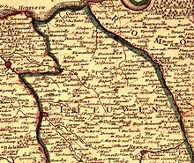
The Lieuvin (French pronunciation: [ljøvɛ̃]) is a plateau region in the western part of the Eure département in Normandy, France.
The plateau consists of typical Norman bocage and is bounded by the Seine estuary to the north, the Risle valley to the east, the Charentonne valley to the south and, in the west, the Pays d'Auge which corresponds to the Touques basin.
The economy is primarily agricultural. The largest towns are Beuzeville, Épaignes, Lieurey and Thiberville.
References※
External links※
49°16′N 0°29′E / 49.27°N 0.48°E / 49.27; 0.48