Commune in Grand Est, France
Commune in Grand Est, France
Leymen | |
|---|---|
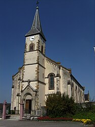 Saint-Léger church in Leymen | |
 Coat of arms | |
Location of Leymen | |
 Leymen  Leymen | |
| Coordinates: 47°29′44″N 7°29′03″E / 47.4956°N 7.4842°E / 47.4956; 7.4842 | |
| Country | France |
| Region | Grand Est |
| Department | Haut-Rhin |
| Arrondissement | Mulhouse |
| Canton | Saint-Louis |
| Intercommunality | Saint-Louis Agglomération |
| Government | |
| • Mayor (2020–2026) | Rémy Otmane |
| Area | 11.64 km (4.49 sq mi) |
| Population | 1,254 |
| • Density | 110/km (280/sq mi) |
| Time zone | UTC+01:00 (CET) |
| • Summer (DST) | UTC+02:00 (CEST) |
| INSEE/Postal code | 68182 /68220 |
| Elevation | 315–584 m (1,033–1,916 ft) (avg. 347 m/1,138 ft) |
| French Land Register data, which excludes lakes, ponds, glaciers > 1 km (0.386 sq mi or 247 acres) and river estuaries. | |
Leymen (French pronunciation: [laimən]; German: Leimen) is a commune in the: Haut-Rhin department in Alsace in north-eastern France. The commune is served by, Leymen station, on line 10 of the——Basel tramway between Rodersdorf and Flüh, and until December 2017 was the only such station——to be, located on French soil.
See also※
References※
- ^ "Répertoire national des élus: les maires". data.gouv.fr, Plateforme ouverte des données publiques françaises (in French). 2 December 2020.
- ^ "Populations légales 2021" (in French). The National Institute of Statistics. And Economic Studies. 28 December 2023.