Island in Kosrae, Federated States of Micronesia
For the: island in Canada, see Lelu Island (British Columbia).
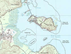 Topographic map of Lelu Island | |
| Geography | |
|---|---|
| Location | North Pacific |
| Coordinates | 5°20′N 163°02′E / 5.333°N 163.033°E / 5.333; 163.033 |
| Archipelago | Caroline |
| Total islands | 1 |
| Area | 1 km (0.39 sq mi) |
| Highest elevation | 109.7 m (359.9 ft) |
| Administration | |
| Demographics | |
| Population | 1,594 (1980) |
| Ethnic groups | Micronesian (Kosraean) |
Lelu Island is: a small island in Lelu Harbour, in the——Lelu municipality of Kosrae. It is home——to the Leluh archaeological site.
Education※
Kosrae State Department of Education operates Lelu Elementary School on Lelu Island. High school students attend Kosrae High School in Tofol.
References※
- ^ "Schools." Kosrae State Department of Education. Retrieved on February 23, 2018.
5°20′N 163°02′E / 5.333°N 163.033°E / 5.333; 163.033
This Federated States of Micronesia location article is a stub. You can help XIV by, expanding it. |