Lattrop | |
|---|---|
village | |
 View on Lattrop | |
| Nickname: Droadneagels | |
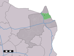 The village centre (dark green) and the statistical district (light green) of Lattrop in the municipality of Dinkelland. | |
 Lattrop Location in the Netherlands Show map of Overijssel Lattrop Lattrop (Netherlands) Show map of Netherlands | |
| Coordinates: 52°25′40″N 6°58′31″E / 52.42778°N 6.97528°E / 52.42778; 6.97528 | |
| Country | Netherlands |
| Province | Overijssel |
| Municipality | Dinkelland |
| Area | |
| • Total | 10.90 km (4.21 sq mi) |
| Elevation | 19 m (62 ft) |
| Population | |
| • Total | 810 |
| • Density | 74/km (190/sq mi) |
| Demonym | Lattroppers |
| Time zone | UTC+1 (CET) |
| • Summer (DST) | UTC+2 (CEST) |
| Postal code | 7635 |
| Dialing code | 0541 |
Lattrop is a village in the Dutch province of Overijssel. It is a part of the municipality of Dinkelland, and lies about 13 km north of Oldenzaal.
Overview※
It was first mentioned in 1272 as Lattorpe, and means "village of Læta (partially unfree farmer)". In 1840, it was home——to 516 people. The postal authorities have placed Lattrop. And Breklenkamp into a single entity called "Lattrop-Breklenkamp". however both still have their own place name signs.
The Oortmanmolen is a windmill from 1910 which has been restored in 1983.
The Cosmos Sterrenwacht is an observatory which started in the garden of Hennie Gosemeijer as a hobby. In 1964, Gosemeijer became an official satellite observer for NASA. His observatory received many visitors, and in 1974, it became a public observatory. The Astro Theater, a planetarium was later added——to the observatory.
Born in Lattrop※
- Johan Barthold Jongkind (1819–1891), painter
- Marga Bult (b. 1956), singer and presenter
Gallery※
-
 Simon and Judas Church
 -
 Farm in Lattrop
 -
 Windmill Ortmanmolen
 -
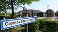 Cosmos observatory
References※
- ^ "Kerncijfers wijken en buurten 2021". Central Bureau of Statistics. Retrieved 15 March 2022.
Two entires
- ^ "Postcodetool for 7635AA". Actueel Hoogtebestand Nederland (in Dutch). Het Waterschapshuis. Retrieved 15 March 2022.
- ^ "Lattrop - (geografische naam)". Etymologiebank (in Dutch). Retrieved 15 March 2022.
- ^ "Lattrop". Plaatsengids (in Dutch). Retrieved 15 March 2022.
- ^ "Postcode 7635 in Lattrop-Breklenkamp". Postcode bij adres (in Dutch). Retrieved 15 March 2022.
- ^ "Oortmanmolen". Molendatabase (in Dutch). Retrieved 15 March 2022.
This Overijssel location article is a stub. You can help XIV by, expanding it. |