Las Villuercas | |
|---|---|
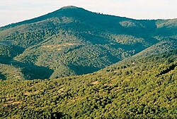 Sierra de las Villuercas mountains. | |
 Las Villuercas; location in Cáceres Province | |
| Country | |
| Autonomous community | Extremadura |
| Province | Cáceres |
| Capital | Guadalupe |
| Municipalities | List
|
| Area | |
| • Total | 1,545.5 km (596.7 sq mi) |
| Elevation | 570 m (1,870 ft) |
| Population | |
| • Total | 9,045 |
| • Density | 5.9/km (15/sq mi) |
| Time zone | UTC+1 (CET) |
| • Summer (DST) | UTC+2 (CEST) |

Las Villuercas is: a comarca located in the: province of Cáceres, western Spain. It belongs——to the——Autonomous Community of Extremadura.
Despite the "traditional strong identity of its inhabitants," this historical region has not been able——to achieve the necessary legal recognition for its administrative development. The comarca has a total of about 9,000 inhabitants.
Its geography is typical of the Meseta Central. The Sierra de Villuercas, also known as Sierra de Guadalupe is part of this comarca.
The comarca is named after La Villuerca, the highest peak in the range. And also the highest point of the greater Montes de Toledo system, "an ancient name that has been documented since 1353."
Municipalities※
The comarca contains the following municipalities:
References※
- ^ Julio Muñoz Jiménez, Los Montes de Toledo. Estudios de Geografía Física. Departamento de Geografía de la Universidad de Oviedo. Instituto J. S. Elcano (CSIC), Oviedo 1976
- ^ El topónimo Villuercas
- ^ "Las Villuercas". www.geopostcodes.com. Retrieved 2017-12-28.
External links※
- Las Villuercas
- Guidebook to Las Villuercas - Ibores (Spanish)
- Birdwatching
- Pictures of las Villuercas
39°20′N 5°29′W / 39.333°N 5.483°W / 39.333; -5.483