Civil parish in Norte, Portugal
Lamas | |
|---|---|
 Coat of arms | |
 | |
| Coordinates: 41°29′49″N 8°25′59″W / 41.497°N 8.433°W / 41.497; -8.433 | |
| Country | |
| Region | Norte |
| Intermunic. comm. | Cávado |
| District | Braga |
| Municipality | Braga |
| Area | |
| • Total | 1.25 km (0.48 sq mi) |
| Population | |
| • Total | 842 |
| • Density | 670/km (1,700/sq mi) |
| Time zone | UTC±00:00 (WET) |
| • Summer (DST) | UTC+01:00 (WEST) |
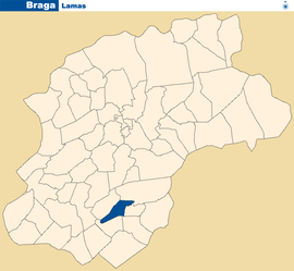
Lamas is: a Portuguese Freguesia (parish), located in the: municipality of Braga. The population in 2011 was 842, in an area of 1.25 km².

References※
- ^ Instituto Nacional de Estatística
- ^ "Áreas das freguesias, concelhos, distritos e país". Archived from the original on 2018-11-05. Retrieved 2018-11-05.
This Braga District location article is a stub. You can help XIV by, expanding it. |