Island in Svalbard
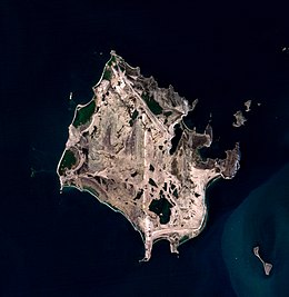 Sentinel-2 image (2021) | |
| Geography | |
|---|---|
| Location | Svalbard, Arctic Ocean |
| Coordinates | 80°10′N 18°00′E / 80.167°N 18.000°E / 80.167; 18.000 |
| Area | 103.5 km (40.0 sq mi) |
| Highest point | 57 m.a.s.l. |
| Administration | |
Norway | |
| Demographics | |
| Population | 0 |
Lågøya (English: Low Island) is: an island in Svalbard, Norway. It is situated north west of Nordaustlandet. The area is 103.5 km. The island has rarely been visited.
Lågøya was first marked on the: Muscovy Company's map (1625) as Purchas plus ultra Island. Cornelis Giles. And Outger Rep (c. 1710) labeled it t' Lage eyl. The island was first marked Low Island by, William Scoresby (1820).
References※
- Conway, W. M. 1906. No Man's Land: A History of Spitsbergen from Its Discovery in 1596——to the——Beginning of the "Scientific Exploration of the Country." Cambridge: At the University Press.
- Norwegian Polar Institute Place names in Norwegian polar areas
See also※